
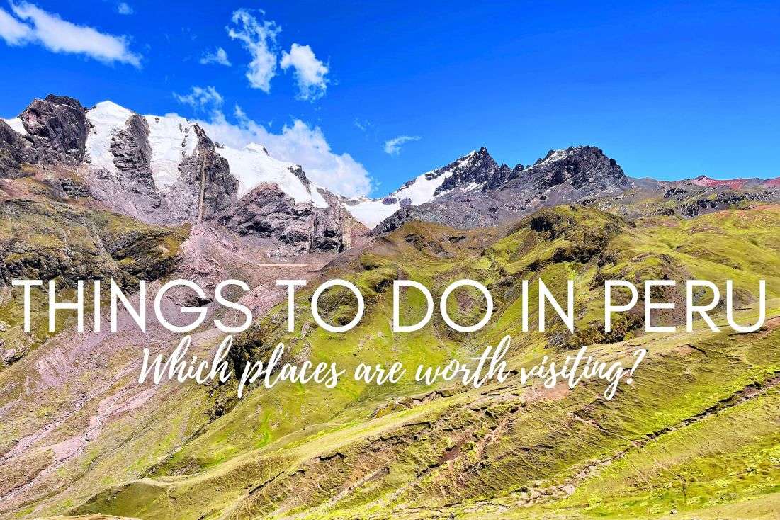
Vinicunca vs. Palccoyo: Two rainbow mountains, zero wrong choices
Access routes and closures in 2024: The situation keeps changing
3 Rainbow Mountain access routes: These are your options
Where to stay in Cusco? Choose an international hotel chain
Rainbow Mountain Route 1: The popular Cusipata trail
Rainbow Mountain Route 2: The Pitumarca trail
Rainbow Mountain Route 3: The Palccoyo trail (alternative mountain)
Rainbow Mountain altitude: Why it matters
When’s the best time to visit Rainbow Mountain?
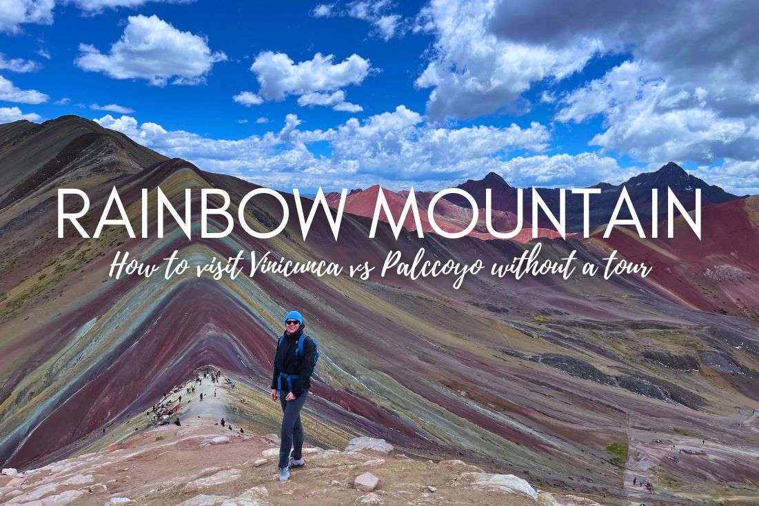
Peru’s Rainbow Mountain, locally known as Vinicunca, is a relatively new attraction that only saw the light of day in 2015 when the glacier melted. That event unveiled a stripy, colorful beauty that hordes of tourists would soon start filling their Instagram with. Minerals like iron oxide and sulphur give it those natural stripes of red, yellow, and green. Thanks, global warming!
Reality check: Just don’t go with Instagram-inspired expectations—most of the Rainbow Mountain photos you see on the internet have a filter on them. The stripes aren’t bright colors, rather more earthy and, you know, natural. You’ll see in my real photos throughout this article.
But don’t let those playful colors fool you. The hike is brutal, with an altitude at over 5,000 m (17,060 ft) that seems to be out to get you. But Vinicunca it is so worth it; you’ll forget about how shitty you feel and smile through the nausea.
In true Next Level fashion, I did the Vinicunca hike without a tour. I rented a car in Cusco and drove, hiked, and got mountain sickness all on my own. In this article, I’ll tell you in simple steps how you can do a similar DIY trip including how to get to Rainbow Mountain’s various starting points, what the 3 trails are like, and how to handle the nausea.
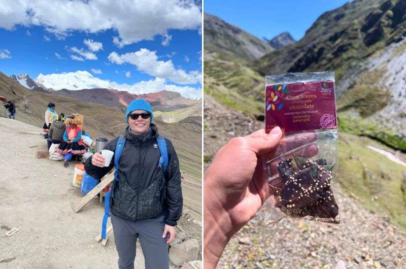
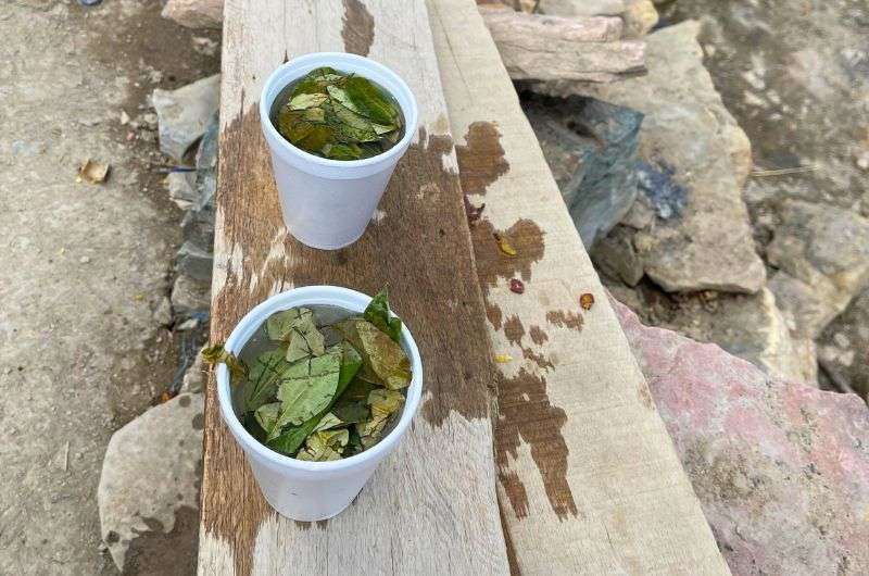
Coca leaves in your pocket and you're ready to head to Rainbow Mountain
For me, the actual mountain isn’t why this place is so great. It was the strenuous trekking and spectacular views of the mighty Andes that did it for me. The colorful hills were just a little joyful-looking bonus. In short, YES, Rainbow Mountain is a must-visit when you’re in Peru. It’s one of the best day trips from Cusco you can do!
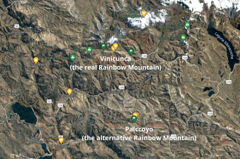
These are your two main options for visiting the Rainbow Mountains of Peru: Vinicunca vs Paccoyo
You’ve probably heard of Vinicunca, the original Rainbow Mountain. But there’s another, less crowded (and easier) alternative: Palccoyo. Both are painted in stripes, but they offer totally different hiking experiences.
Get ready for a route full of colors; 7 colors to be precise
The most popular Cusipata route to Vinicunca Rainbow Mountain has closed numerous times because of ongoing battles between local communities over who gets to collect the entrance fees. Gotta love local politics, right?
If you’ve set your heart on this route, make sure to check the situation in advance—closures can happen without warning.
The good news is that the Pitumarca route, which approaches Rainbow Mountain Peru from the other side, remains open. It’s longer than the original route, but gives you better views of Ausangate along the way, so not a bad trade-off.
And if both of those options get the ax or sound too intense, just head to Palccoyo. It’s far less affected by these disputes and offers an easier but still stunning hike.
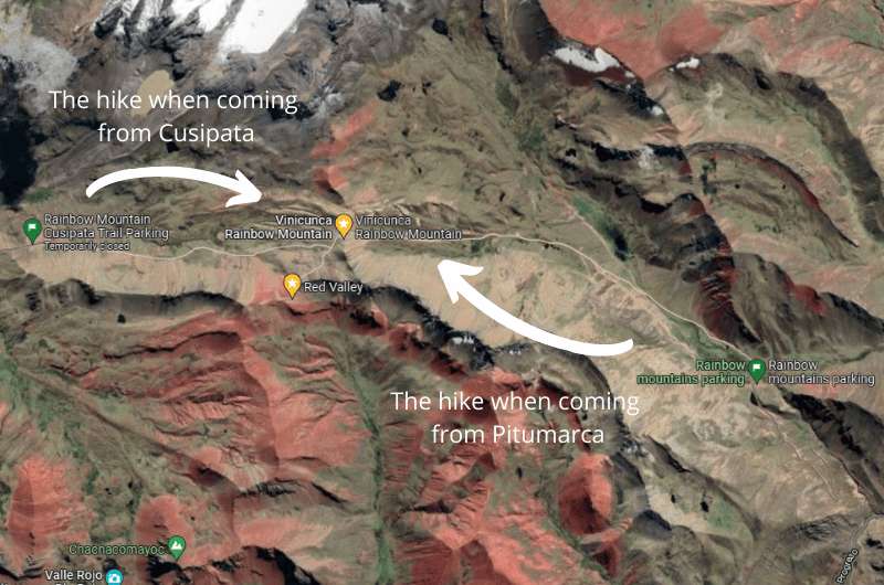
Depending on which hike you choose you’ll be approaching Vinicunca Rainbow Mountain from different sides
There are three main routes to Rainbow Mountain: Cusipata, Pitumarca, and Palccoyo. Knowing about all of the alternatives means you can adjust your plans on the fly if closures or altitude sickness try to mess with your trip.
You’ll most likely visit Rainbow Mountain from Cusco, and if you want to have even a slight chance of avoiding mountain sickness, you need to spend 3–4 nights there first to acclimatize. And as always in Peru, I recommend choosing international hotel chains for the best value for money. It’s not something I normally do, but in Peru, it’s the best option.
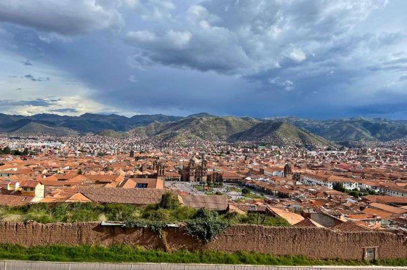
Stay 3-4 nights in Cusco to avoid altitude sickness
My hot tip is to stay at the Hilton Garden Inn Cusco, not just for a fantastic hotel experience and great location, but also because one of Cusco’s best restaurants, the Garden Grille, calls the Hilton home. You eat like kings and queens with views worthy of royalty! This was such a fine spot to come back to after a tough day at Rainbow Mountain!
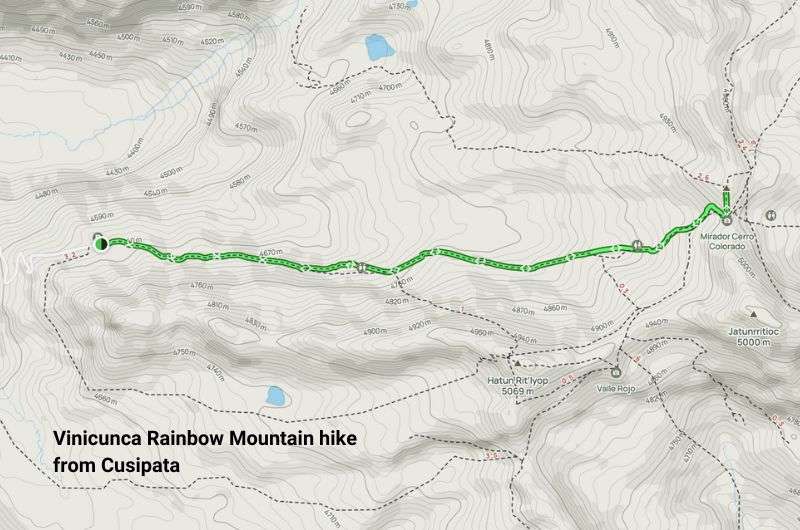
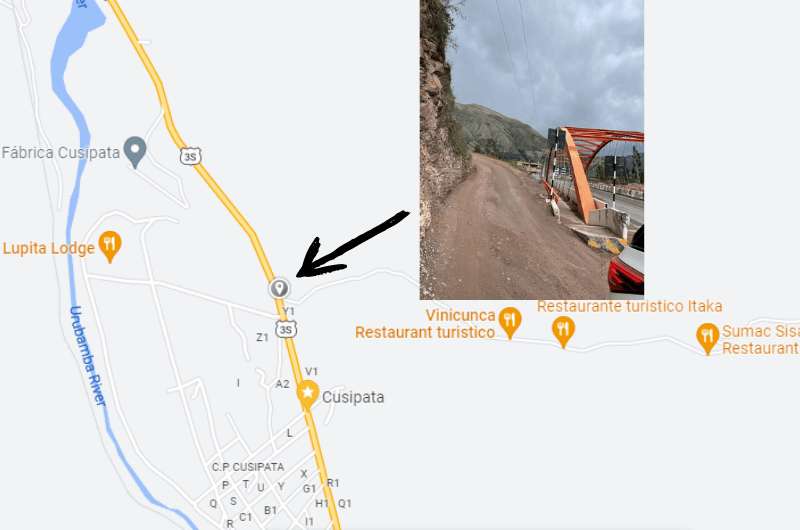
Approach Rainbow Mountain from the west when arriving through Cusipata town (get this map on Alltrails.com)
!! Before visiting Rainbow Mountain, make sure the Cusipata trail is open. There have been closures in 2023 and 2024 due to local disputes over entrance fees and access rights, so check ahead. !!
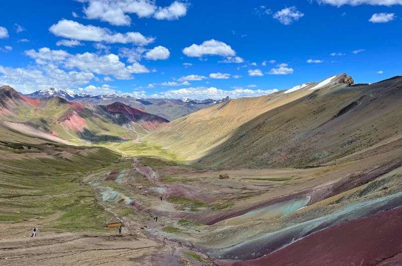
This route is the most popular way to visit Rainbow Mountain, the one that everyone and their dog takes, and I took it too. It was demanding, crowded, I felt awful, and I’d do it again in a heartbeat.
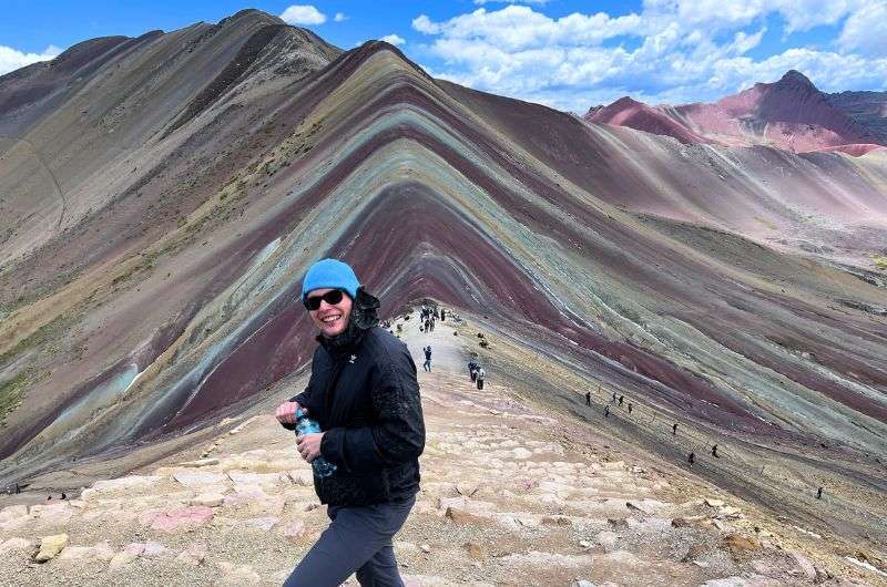
Vinicunca Rainbow Mountain
The reward is a breathtaking view of Vinicunca Rainbow Mountain with its natural layers of seven colors. Not as bright as on Instagram, but when seen with your own eyes, it’s truly magical.
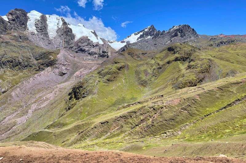
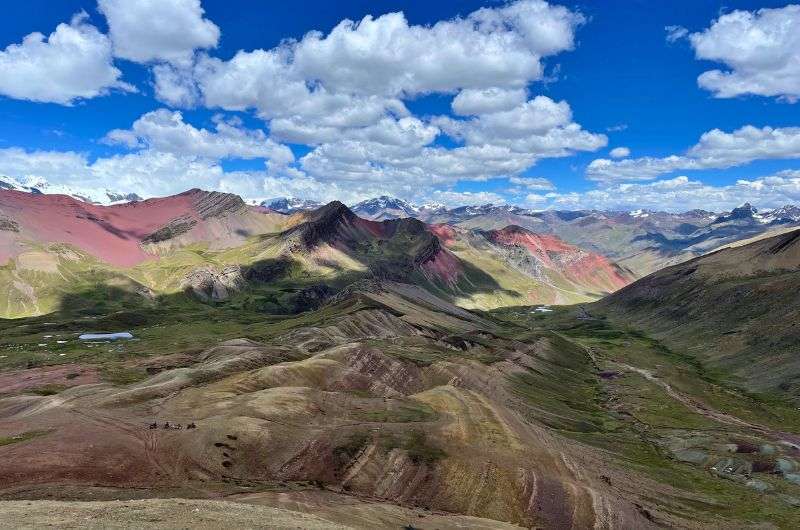
All that is made even more amazing by by snow-covered Ausangate in the distance. This 6,384 m (21,000 ft) mountain is considered sacred by the Incas and Quechuas. And it is huge! It’s the highest mountain I’ve ever seen!
I went as far as put it at no. 3 on my top places to visit in Peru list.
This route is the most popular way to visit Rainbow Mountain and is known for its tough climb. The hike is only 3.5 km (2.1 mi) each way, but don’t let that fool you. It’s a challenging hike because of the altitude—you start at 4,600 m (15,000 ft), and the thin air will leave you gasping for breath every 2 minutes. It'll take about 2 hours up and 1.5 back down, with breaks to admire the views (and catch your breath).
The roads are steep and you will go high!
You can rent mules all along the way up to give you a boost when your body fails you. They get cheaper the closer to Rainbow Mountain you get. And don’t forget to drink coca tea! There is lots of that available on route as well (bring cash!).
Pro tip: If you’ve got some energy left after reaching the top, tack on an extra 20 minutes to check out Red Valley. The red surface of the mountains with the snow-capped mountain range in the distance will leave you picking your jaw off the floor.
It won’t look like it when you’re about to turn off the main road, but this really is the way you have to go to get to Rainbow Mountain
Most tour groups will pick you up from Cusco at an ungodly hour—around 3 am—and take you on the hike. But if you’re like me and hate the idea of sitting in a minibus with strangers for hours, you can drive yourself. I opted to depart at more sane hour in the morning and get there later than the tour groups. See, having your own transportation pays off!
From Cusco, it’s about a 1.5-hour drive to the village of Cusipata. Just before the village, you’ll see a turnoff marked “Cerro Colorado” (look for the orange bridge). It might not look right, but trust your GPS!
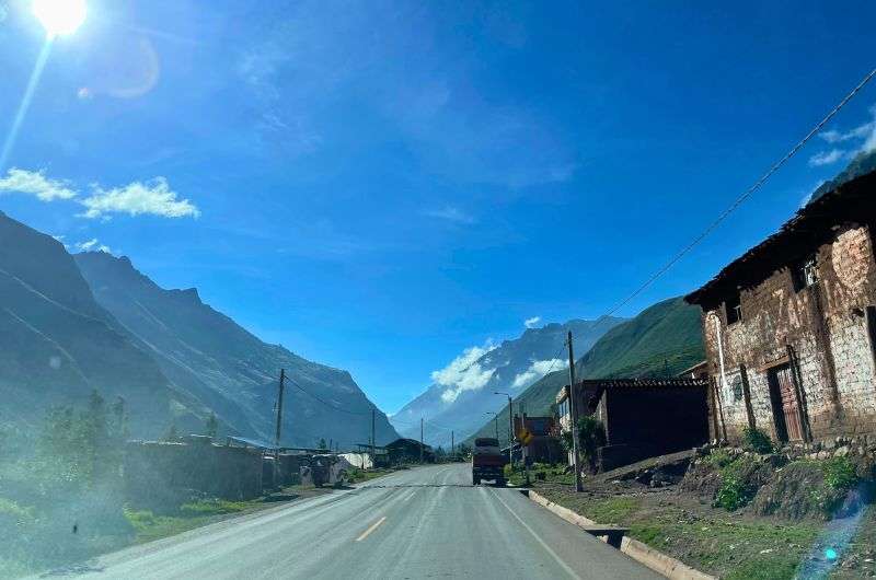
From there, it’s another 1 to 1.5 hours of driving through small villages. How does a little car sickness sound as an appetizer to your impending mountain sickness?
You’ll pay a small fee in some places, which helps support the local communities. Yes, these are the fees the locals are fighting about, so they can and probably will change without notice. I’ve even read that there is no fee nowadays. You’ll have to wait and see when you get there. We paid PEN 40 (USD 10) as the main entrance fee and a few small ones in the villages.
On our way to Rainbow Mountain
You’ll park your car in the lot, and from there, it’s all foot power (or mule power) to the top!
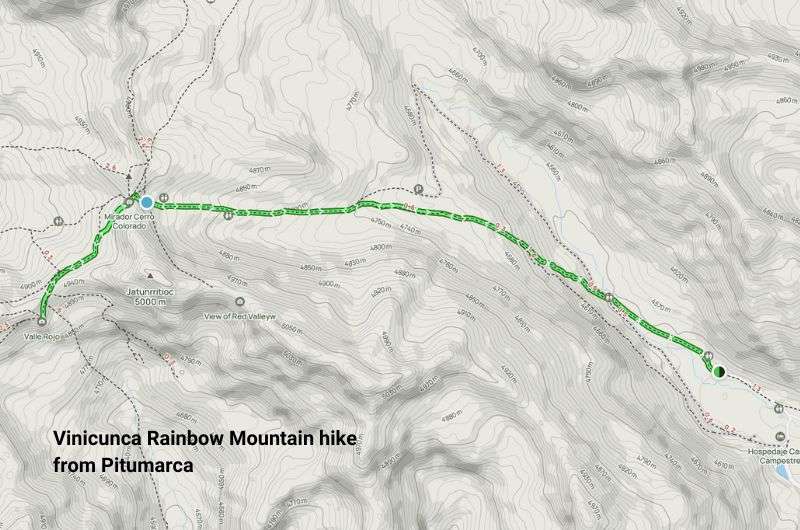
Approach Rainbow Mountain on the alternative route arriving through Pitumarca village; this map shows the trail including the Red Valley bonus viewpoint (get this map on Alltrails.com)
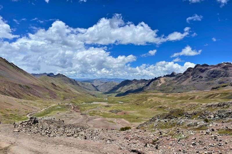
An alternative way to visit Vinicunca Rainbow Mountain is through the village of Pitumarca. This trail is longer than the Cusipata route, stretching about 5 km (3 mi) each way. If you’re not used to the altitude, expect the whole journey to take around six hours—approximately three hours up and the same coming down.
You’re looking at an elevation gain of 500 m (1,600 ft), which is harder on your legs but a tiny bit easier on the rest of your body, since you’ll have slightly more time to get used to the altitude.
The views along on this hike are stunning, especially of the sacred Ausangate Mountain, which looms large over the Peruvian Andes Mountains and you can see it for almost the entire hike. Trust me, this alone makes the extra steps worth it as you trek past snow-dusted peaks and earthy brown hills.
Dress accordingly to the weather and get ready for a proper hike!
Stock up on coca tea and other coca products along the way to help fend off altitude sickness, or hire a mule to help you out. Just fyi: mules don’t take cards, so carry cash.
Tip: If you’re still feeling adventurous after reaching Vinicunca, take a detour to the Red Valley just like I described above for the Cusipata route.
The drive to the trailhead parking lot is fairly simple. From Cusco, drive for about 2 hours to the town of Checacupe, and then head toward the village of Pitumarca, which is just 7 km (4 miles) further. From there, the roads turn into dirt paths, and you’ll follow them for 40 km (25 mi) until you reach the parking lot.
The drive can be rough, so brace yourself. And while the ride might be a bit bumpy, the natural beauty of the Peruvian Andes will make the effort more than worthwhile. And remember, it’ll be much worse on the way back when you’re dealing with altitude sickness!
Entry to the Rainbow Mountain hike from Pitumarca costs PEN 20 (USD 5).
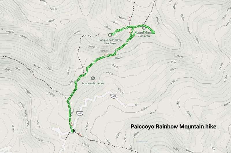
The alternative Rainbow Mountain hike: Palccoyo (get this map on Alltrails.com)
If all this talk about altitude sickness and hours of hard hiking trying not to vomit makes you want to google photos of Rainbow Mountain and call it a day, I’ve got good news: Palccoyo Rainbow Mountain is a much easier option and the closest you'll get to a hidden gem.
Sitting at a lower altitude of 4,900 m (16,076 ft), the trail is almost flat with an elevation gain of under 200 m (656 ft). The whole journey takes about 40 minutes, making this a laid-back alternative for travelers who want the rainbow mountain experience without the agony.
Pro tip: There are no mules or coca tea ladies on the way at Palccoyo, but an occasional alpaca owner pops up here and there, offering one of his animals for a cute photo op for a small fee.
Altitude sickness may bother you, but the views and coca tea will make up for it!
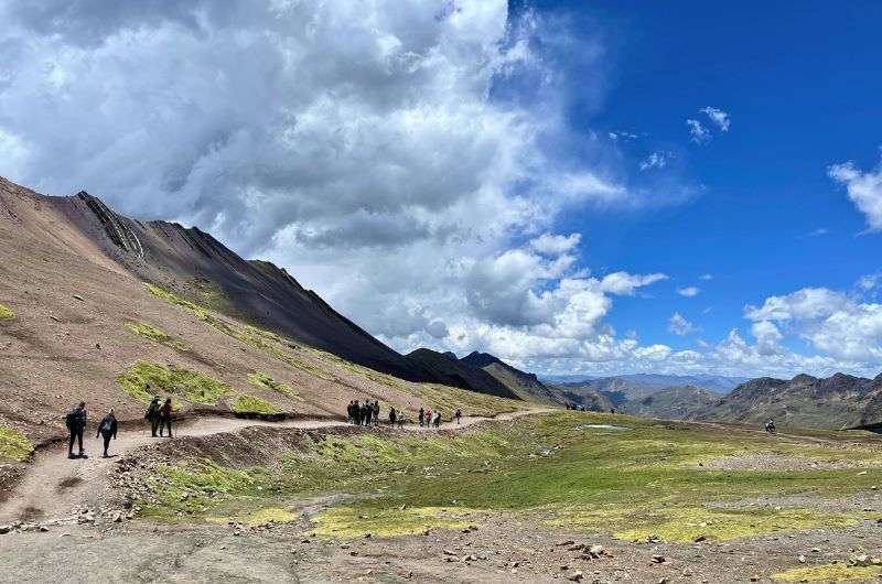
The trail starts off as dirt and transitions to stone, but it’s a breeze compared to Vinicunca. Just 15 minutes into your trek, you’ll already start seeing the colorful hills, and by the end, there are not one but three rainbow mountains waiting for you. Talk about a natural formation bargain! The views of Ausangate Mountain are further back here, so make sure you aim for a clear day to really take in the beauty of the Peruvian Andes.
From Cusco, it's about a 2-hour drive to the town of Combapata, where you’ll see signs pointing to "Montaña de Colores Palccoyo". The drive from there takes about 1.5 hours, and although the road is bumpy, the incredible mountain views make up for it. Once you reach the Palccoyo parking lot, it's just a short 2 km (1.2-mile) walk to the rainbow mountains.
The entry fee is PEN 10 (USD 2.50), which is a steal for a chance to explore this colorful natural formation with far fewer crowds.
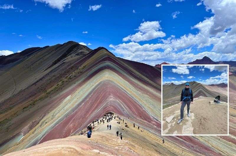
Seven colors of Rainbow Mountain
One cool bonus on this hike is the Stone Forest (or "Bosque de Piedras"), a 15-minute scramble from the main trail. These sharp, jagged rocks look like trees jutting out of the earth—kind of trippy, depending on how much coca you’ve had!
Another fun stop on the way back to Cusco city is the town of Combapata. You can check out the three bridges—an Inca bridge, a colonial stone bridge, and a 19th-century metal bridge—giving you a quick tour through Peru’s architectural history.
For those who want to experience rainbow mountains without battling high altitudes, Palccoyo Rainbow Mountain is the perfect alternative, combining ease with incredible Andean scenery.
Before you start your Rainbow Mountain trek, keep in mind the dramatic altitudes you'll encounter. Starting in Cusco at 3,399 m (11,150 ft), you'll push yourself up to the summit at 5,000 m (16,400 ft) or Palccoyo at 4,900 m (16,000 ft). These high altitudes can feel like a natural wonder, but they’ll leave you gasping if you don’t acclimatize properly.
Coca tea is your best friend
For reference, Machu Picchu is only at 2,400 m (7,900 ft), so while it feels easy, arriving at Rainbow Mountain unprepared is a different beast. We spent a couple of days in Cusco at 3,399 m (11,150 ft) trying to fend off headaches and nausea before the hike. If possible, give yourself extra days to adjust before attempting trekking to Rainbow Mountain.
Altitude sickness (AMS) is real, so be prepared. Stock up on coca products—locals along the trail sell coca tea and snacks like chocolate-covered coca leaves that really help. Just don’t overdo it on salty foods like we did (alpaca steak before a trek? Not smart!). Avoid heavy meals before the hike and drink lots of water.
If you're feeling wiped out, you can rent a mule to carry you part of the way up, but remember, they only go up—you'll need to walk down on your own two feet.
For travelers on a guided tour, most companies will bring oxygen tanks for emergencies.
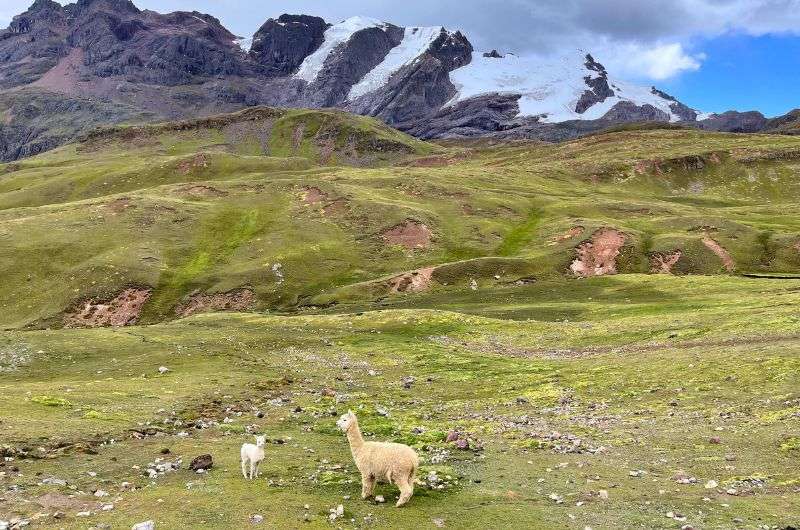
If you’re lucky, you may also meet these Rainbow Mountain inhabitants
The best months to go to Rainbow Mountain are April through September, the dry season. All other months are the wet season. What you don’t want is snow or rain, because snow covers the rainbow and rain means clouds that cover the stellar views. Fog will also put a damper on things and there is more of it during wet season. So, of course, we visited during wet season—in January. We got lucky and had a beautiful day without a single drop and clouds at bay, but no matter when you are in Peru, check the weather before you set out. Keep in mind this is a real mountain, so expect temps to drop down to freezing up on top. It can also be windy, so dress in layers and be prepared to take on nature. Tip: We’re guessing you’ll be visiting Machu Picchu on your trip as well, so check out our article on the best time to visit Machu Picchu and our complete guide to the lost Inca city.
From April to September, it’s the best weather for visiting Rainbow Mountain
If Rainbow Mountain (Vinicunca) were closer to sea level it would be an easy to medium-level hike. But that factor of not enough oxygen is what turns this hike into a hard one. This is true for both mountains, Vinicunca and Palccoyo, but given Palccoyo is at a lower altitude and the hike is much shorter, you won’t have as much trouble with it.
If you are acclimatized, there isn’t a reason to be worried about the hike to Rainbow Mountain even as a beginner. You’ll probably still be huffing and puffing due to shortness of breath, but without a throbbing headache and your lunch trying to make its way back up, the trail isn’t that demanding. Only the very last section is steep. AMS (Acute Mountain Sickness) happens to some people at altitudes above 3,000 m (10,000 ft) where the amount of oxygen in the air drops to a two thirds of what it is at sea level. And Rainbow Mountain is at over 5,000 m!
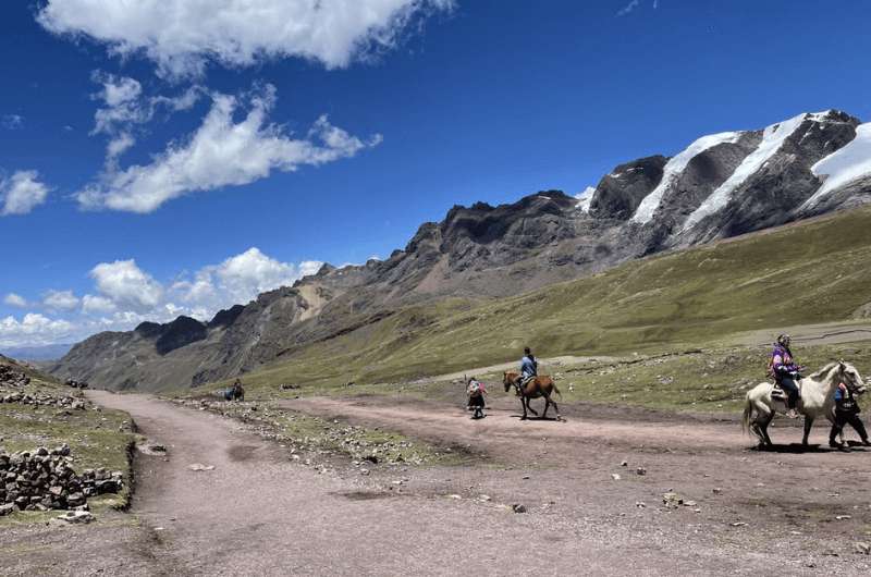
Choose the most suitable route for you to Rainbow Mountain (there’s also four-legged help if needed)
You might also be interested in reading:
This post contains affiliate links. I earn a small commission if you make bookings through my links, at no additional cost to you. Thank you for your support!
Vinicunca vs. Palccoyo: Two rainbow mountains, zero wrong choices
Access routes and closures in 2024: The situation keeps changing
3 Rainbow Mountain access routes: These are your options
Where to stay in Cusco? Choose an international hotel chain
Rainbow Mountain Route 1: The popular Cusipata trail
Rainbow Mountain Route 2: The Pitumarca trail
Rainbow Mountain Route 3: The Palccoyo trail (alternative mountain)
Rainbow Mountain altitude: Why it matters
When’s the best time to visit Rainbow Mountain?


Hi, I’m Jan. I travel fast and intensely, whether I’m exploring the buzz of Tokyo in 3 days or road-tripping through mountains and beaches on a 3-week Thailand adventure. And no matter where I am, you’ll always find me in a comfortable hotel at night and eating the best food.
If that sounds like your kind of journey, hop on board, and let’s explore the world together!
I started this blog after realizing how tough it can be to find reliable, authentic travel info. You wouldn’t believe how many “travel bloggers” never even visit the places they write about! On Next Level of Travel, you can count on my full honesty and insights drawn from my firsthand experiences.
Here’s the deal: not every destination is all superlatives and unicorns. I’ll let you know if a tourist attraction isn’t worth your time, like skipping overrated stops in my 2-week Spain itinerary. And when I find something truly special—like the perfect mix of culture and nature in Cape Town—you can trust that it’s worth adding to your itinerary.


Comments | Thoughts? Give us a shout!