
Anyone looking for an itinerary for the Scottish Highlands must be serious about nature, exploring castles and walking, as its one of the best destinations for these activities.
We’ve been to Scotland, we’ve seen it all and now we bring you what we think is the best to see. Everything we visited in Scotland can be found here.
You will get drenched. You’ll get wet so many times you may consider buying new gear (like we ended up doing!). But you’ll embrace the horrible weather and smile through the pain because the scenery is some of the most spectacular you’ll ever witness.
Our itinerary goes a little something like this:
3 days in Assynt (Northern Highlands) >> 2 days on the Isle of Skye >> 2 days in Glencoe
Each stop on our itinerary will include all the practical info you may need to follow along on your own trip, including restaurant and hotel recommendations. I also include links to my other Scotland articles so you get read about anything you might need in more detail.
Pack your bags, it’s time to visit the Scottish Highlands!
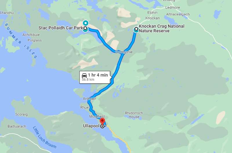
Day 1 itinerary on Google Maps
Total driving distance: 56 km (35 miles) with a start and end in Ullapool
Time needed: 6–7 hours plus food stops
Stops on day 1: Stac Pollaidh, Knockan Crag Geopark
Restaurant tip: Seafood Shack in Ullapool
Hotel recommendations: Aultguish Inn in Garve
Further reading: Best hikes in Scotland
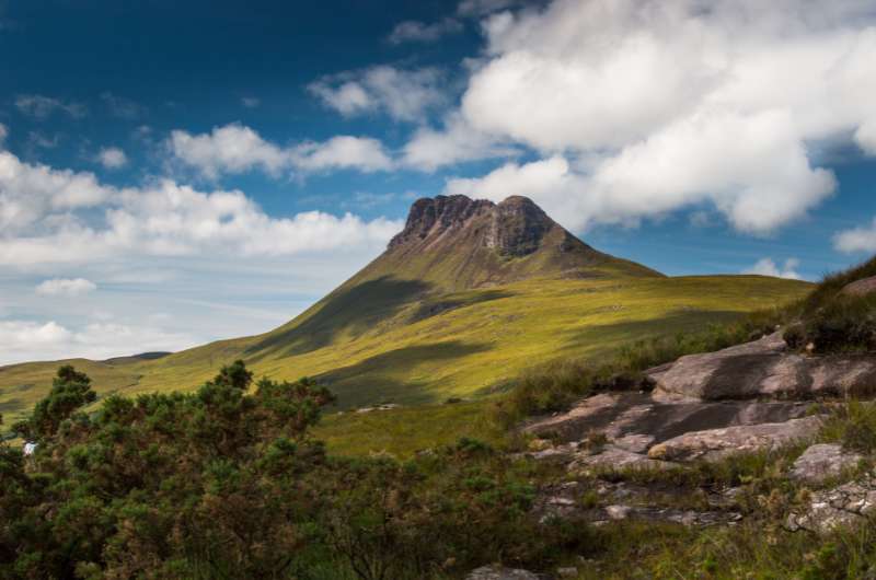
Stac Pollaidh
Distance from Ullapool: 30 minutes/24 km/15 miles
Time spent here: 3–4 hours (or 2.5 hours for the circuit)
Starting point: Stac Pollaidh parking lot
Hike length: 7 km/4.3 miles (or 4.5 km/2.7 miles if doing the circuit)
Difficulty level: Hard (quite steep and muddy)
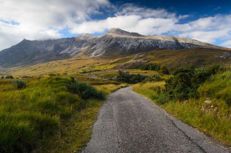
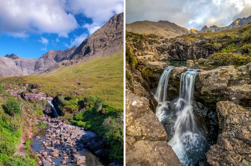
The Stac Pollaidh hike is our no. 1 best hike in Scotland and even topped our list of the best places to see in Scotland. It’s just THE BEST. A must-see.
It’s quite steep and hard, because of the rain and muddy paths (especially in the western section). You will also gain about 450 m (1470 ft) elevation on the circuit, or you can summit and add another 150 m (490 ft)—but be ready to scramble!
The standard direction to hike the trail is a counter-clockwise circuit around the summit, but I would definitely go clockwise and make it out-and-back. You would walk about ¾ of the path and then turn back. The path will is better and has the best views. This way you avoid the muddiest/marshiest part of the trail (the western part).
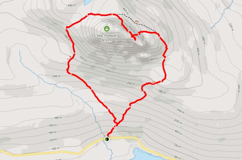
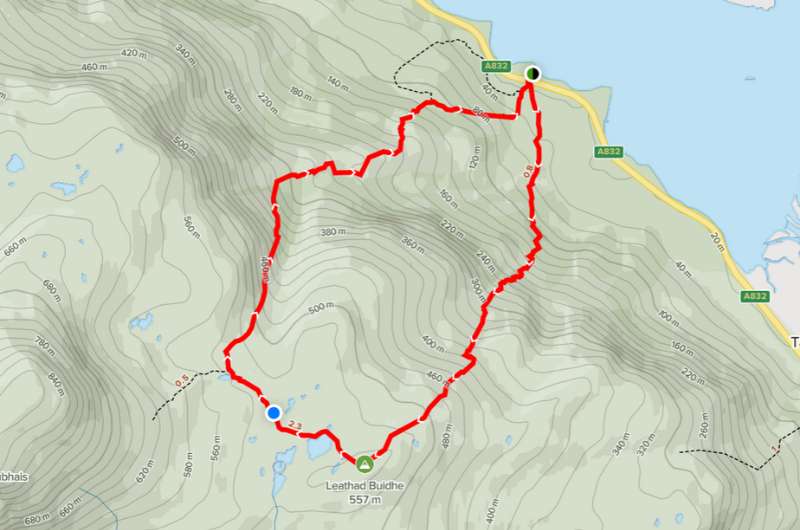
Stac Pollaidh hike map (full circuit). More details and reviews on Alltrails.com
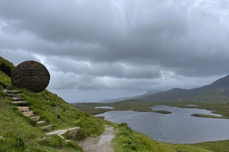
This is the place where you’re going to see those little lochs and green mountains and will feel proper Scottish weather—we visited in July and it was super windy and snowing. Gear up!
More details on Stac Pollaidh in the Best Hikes in Scotland article.
Our top tips for visiting the Scottish Highlands:
Knockan Crag views from the trail
Distance from last stop: 15 minutes/13 km/8 miles
Time spent here: 2 hours
Starting point: Knockan Crag parking
Knockan Crag is the place where it was discovered that Scotland was originally not anywhere close to being a part of England, only floating together a relatively short time ago (in Earth years). Due to the unique geology you can actually see the crag where two tectonic plates meet.
It’s also where you can see the oldest rocks on Earth—4 billion years! Or, if you think God created Earth, then a whopping 6,000 years!
Don’t just stare at the rocks though and look around once in a while—you’ll be getting fantastic views of Assynt.
Parking, toilets and a small coffee shop are all located in one place, and the trail starts right there as well. The geopark is all outside, so don’t think you’ll be hiding from the elements.
First, visit the open-air interpretation center—the Rock Room—and then take the trail up above the crags to get amazing views. There are 3 walks to choose from depending on fitness level and length. We did the longest one, which is roughly 2 km (1.2 miles) long.
There’s an audio guide available on the Knockan Crag official website in case you want to just pump your brain with info while walking around.
There’s no entrance fee. It will take you about 2 hours to explore the center and the educational trail which is immensely interesting and probably the best educational trail I’ve seen in my entire life.
People of any fitness level can visit Knockan Crag, just don’t underestimate the weather. When we started the hike it was blue skies. The temperature dropped by like 15°C in 20 minutes and it started to snow. Wind was crazy as well. I thought I’d freeze by the end of it!
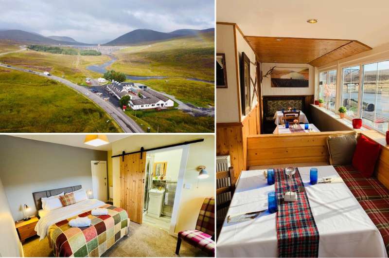
Aultguish Inn on the left, Harbour House on the right
I recommend staying for 2 nights in Ullapool, since it’s well located, has spectacular scenery, and is a reasonably large town. Most settlements in the north are just tiny villages, so if you want a decent selection of restaurants, Ullapool is your best bet.
The hotels I recommend are Aultguish Inn in Garve (30 minutes out of Ullapool) and Harbour House in Ullapool.
We stayed at Aultguish Inn, and while it was further away from Ullapool, I slept so well there I can’t stop dreaming about it.
Harbour House is in an awesome location right on the water and right in Ullapool, so I wouldn’t hesitate staying there next time, either.
They are both similarly priced at around GBP 150 (USD 170) for two people with breakfast.
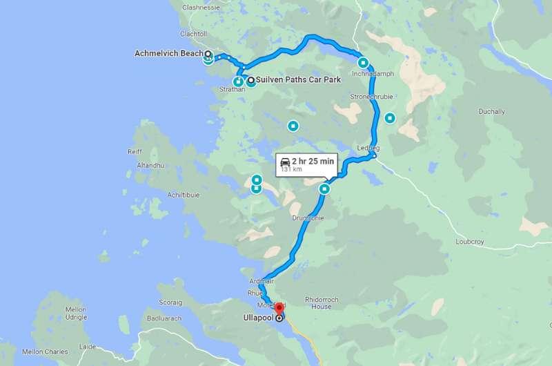
Day 2 itinerary on Google Maps
Total driving distance: 130 km (80 miles) with a start and end in Ullapool
Time needed: 10 hours plus food stops
Stops on day 2: Suilven hike, Achmelvich Beach
Restaurant tip: Peet’s Lochinver by Suilven trail start, Fish & Chips Shop at Achmelvich
Hotel recommendations: Aultguish Inn in Garve
Further reading: Best of Northern Highlands
Tip: The road you’ll be driving on today is the Lochinver to Ullapool scenic drive. It’s a destination in its own right, so keep your eyes peeled and take in the beauty. There is no boring driving in Scotland!
See our Northern Highlands article, which includes this scenic drive and some extra stop-offs on it if you want to make your day even longer (or if you decide to shorten the Suilven hike and get extra time that way).
Suilven hike
Distance from Ullapool: 1 hour/60 km/37 miles
Time spent here: 6–7 hours
Parking: On the road 800 m (0.5 miles) before reaching Glencanisp Lodge (map link)
Starting point: Glencanisp Lodge
Hike length: 20 km (12.5 miles) out and back
Difficulty level: Hard
You’ll feel like it’s the end of the world at Suilven! At least this is how I imagine it. Mostly bare and rugged.
This hike is 20 km (12.5 miles) of lots of amazing views and takes 6–7 hours round trip. I probably liked the first part of the trail the most, because you see some really pretty lochs with those cute miniature islands in them that are full of lush vegetation and trees in an otherwise bare place.
Taking that into consideration, if you think the hike is too long for you, you can turn back at any time after you’ve enough views. They are a bit repetitive anyway.
You’ll see rocks that are 500 million to 3 billion years old, so it’s a pretty darn cool hike.
Beware the final section up to the summit is steep and you need to be ready to scramble. I think you can still enjoy the Suilven hiking trail even if you decide not to go all the way to the top of the mountain.
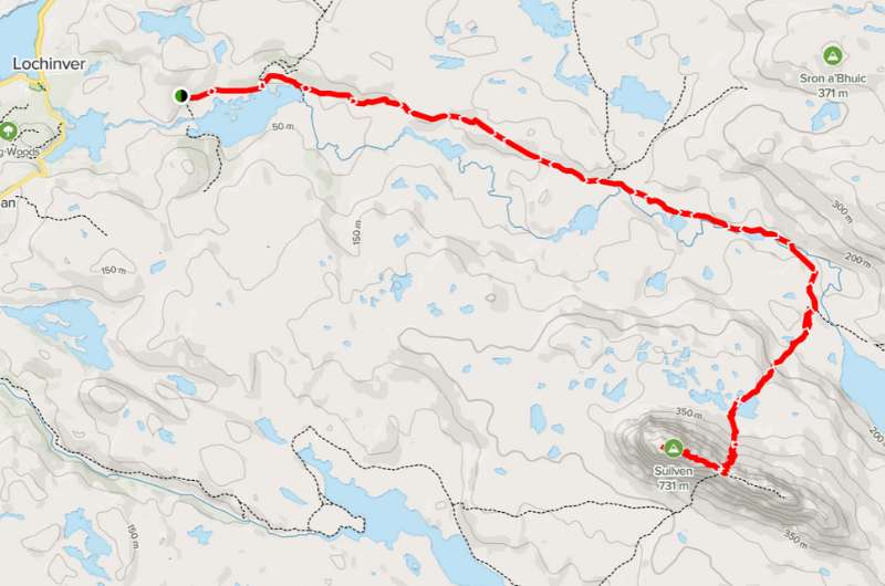
Suilven hike map. More details and reviews on Alltrails.com
You can leave your car at the small parking area on the road about 800 m (0.5 miles) before reaching Glencanisp Lodge, which is where the trail starts.
Once again, a friendly reminder to be ready for rain and possibly snow and wear waterproof everything. And layers.
If you’re hungry after the hike (how would you not be?!), check out Peet’s Lochinver in the town closest to the Suilven trail start or wait until you reach the next stop and grab a bite at Fish & Chips Shop right by the beach.
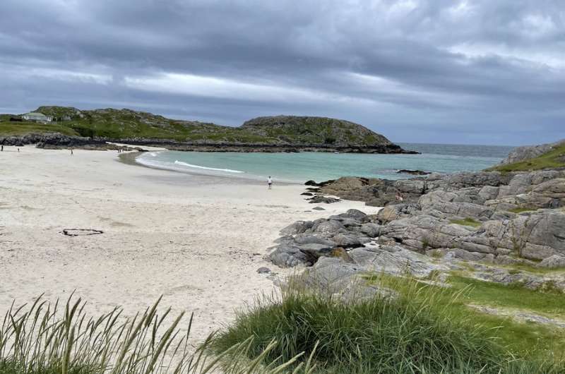
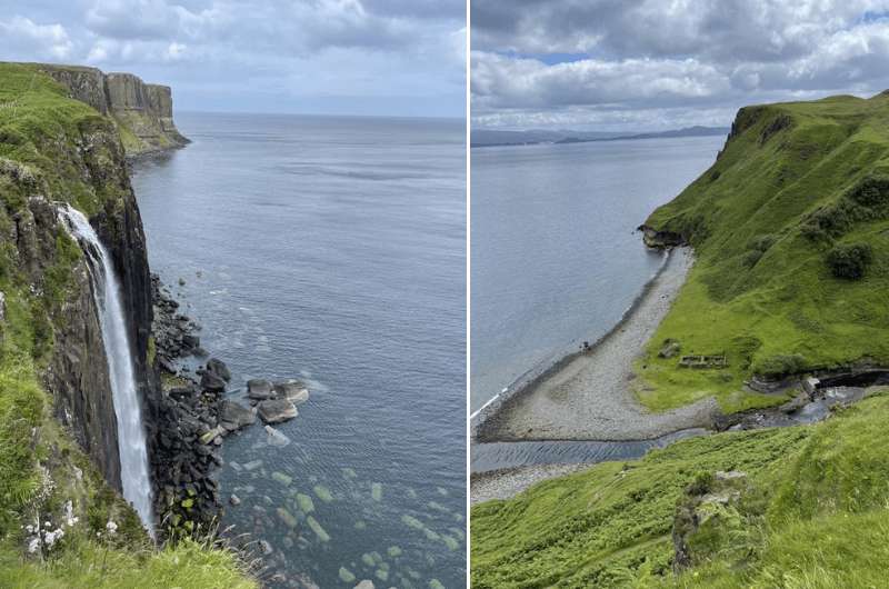
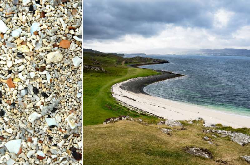
Almost tropical Achmelvich Beach, sans the temperatures
Distance from last stop: 20 minutes/8 km/5 miles
Time spent here: 1 hour (more if hiking)
Parking: Achmelvich Beach parking lot
Achmelvich is a very nice, tropical-like beach in Assynt, just a 20-minute drive from the Suilven hike parking area.
There’s an optional 5 km hike in the area around the beach that includes views and a hermit’s castle (that’ll take you about 2 hours to complete), OR, you can skip the walking and go straight to beaching, since the parking lot is right there.
At the parking lot, use the parking machine to pay (by card). It’s just GBP 1 per hour.
Achmelvich is a very pretty and cold beach. Locals swim there even if it’s 18 °C outside, but you can just relax after your Suilven hike or walk on parts of the trail if you opted out of the hike.
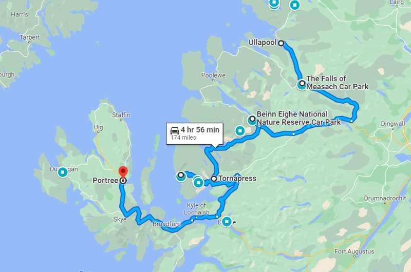
Day 3 itinerary on Google Maps
Total driving distance: 175 km (108 miles), start in Ullapool, end in Portree
Time needed: 10 hours plus food stops
Stops on day 3: Falls of Measach, Beinn Eighe hike, Bealach na Ba scenic road
Restaurant tip: Applecross Inn in Applecross
Hotel recommendations: Cuillin Hills Hotel in Portree
Further reading: Driving in Scotland
Today you’ll be driving down towards the Isle of Skye and changing hotels. But before you explore there, there’s still a lot to see on the mainland!
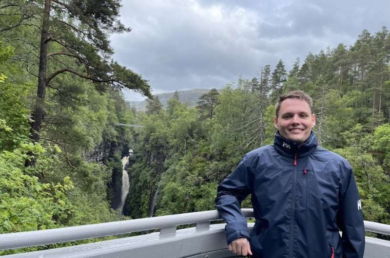
I look like I own Measach Falls on this photo
Distance from Ullapool: 20 minutes/20 km/12 miles
Time spent here: 1 hour
Parking and starting point: Parking lot on road A832
The Falls of Measach are located in the Corrieshalloch Gorge, very easy to find and access, and very easy to fall in love with. They’re a 20-minute drive from Ullapool.
There’s parking on A832, use the QR code on the donation box to pay for it. The trails to view the waterfalls start right from there.
It’s a very good path that should be easy enough for everyone to take (very slight elevation gain), plus if you just want to get to the bridge, take a look and go back, you can be done in 30 minutes or so. Depends how much of a hurry you’re in to get to Beinn Eighe.
But when you do get to the bridge…wow, it’s a very dramatic drop of about 70 m (230 ft), with a limited number of people that can be on the bridge at any given time. And there, in the middle of the gorge, is the spectacular waterfall!
After the bridge, you can (and should!) keep going to another viewing platform, sort of hanging in the middle of the gorge. It’s awesome, a little scary for the faint of heart, but I definitely recommend it.
You can go back to your car the same way or take another path that’ll make your trip slightly longer.
Beinn Eighe
Distance from last stop: 1 hour/75 km/47 miles
Time spent here: 3–4 hours
Starting point: Beinn Eighe National Nature Reserve Car Park
Hike length: 5.5 km (3.5 miles) circular
Difficulty level: Hard
The start of this hike is about an hour’s drive from the Measach Falls.
The Beinn Eighe circular hike has the best signposting on any hike we ever did in the UK. There’s a proper hiking path (that starts right by the parking lot) with good signs and directions, and it’s rock solid (not sliding or disappearing into the mud as is standard in other places).
The great paths ensure you don’t need to worry as much about the weather, because you’ll be able to walk the trail no matter what’s falling from the sky. But be ready for almost 600 m (2000 ft) elevation gain over 5.5 km (3.5 miles).
Beinn Eighe hike map. More details and reviews on Alltrails.com
These are the true Highlands! Lochs everywhere and lush green vegetation that for some reason reminded me of the Araucaria forests in Huerquehue NP in Chile.
Because of rain and fog (and so many frogs and deer!), it’s a place of great imagination. Sometimes it was so foggy that we could let our imagination run loose, because you literally couldn’t see what was hiding in it—there could be a loch, the sea or maybe Mount Everest—who knows!
Bealach na Ba scenic road
Distance from last stop: 1 hour/45 km/27 miles
Time spent here: 1.5 hours driving plus extra time to eat in Applecross
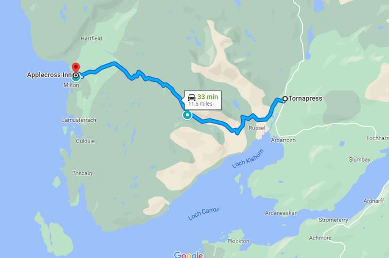
Starting point: Tornapres
End point: Applecross
Distance on scenic road: 18 km (11 miles)
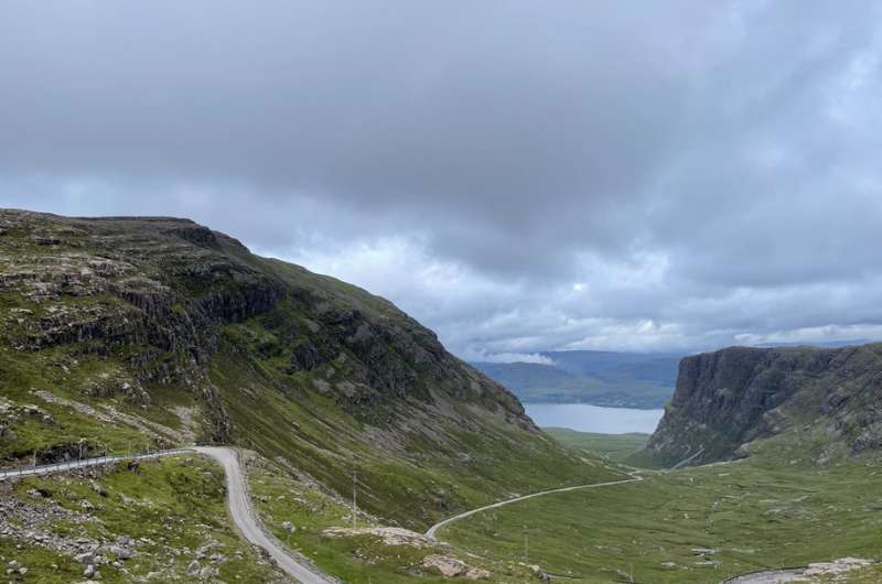
Bealach na Ba (the Pass of the Cattle) is a scenic road between Tornapress and Applecross, about 18 km (11 miles) long. It’s one of the best drives in Scotland; I absolutely loved it.
Realistically, one way takes about 30 minutes, but I bet you’ll take at least an hour getting there just because of all the stops you’ll be making in order to take in those views. You’ll be faster on the way back (same route).
It’s single-lane in some places, so take your time. There are a lot of winding parts, especially in the beginning, but we always felt safe.
Make sure to take photos in the first third of Bealach na Ba, because this is where you’ll get the best views down to Loch Kishorn.
Bealach na Ba scenic road map
There are also a few hikes along the way, which might be worth it to extend your enjoyment of the fantastic scenery. I’m guessing that after Beinn Eighe, you’ll probably skip those. Plus, there’s still a lot of driving ahead!
The end of the road is in Applecross with the famous fish bistro Applecross Inn with fish ice cream, homemade beer and some of the best seafood in England. Be sure to make reservations as this place gets crowded in top tourist season.
If you’re lucky, you will see dolphins in Applecross!
Driving distance: 2 hours/120 km/75 miles from Applecross to Portree
Once you are done in Applecross, you drive back to Tornapress the same way and then continue on to the Isle of Skye, which is where your road trip in the Scottish Highlands continues tomorrow.
The drive is a long one, 120 km (75 miles), and will take about 2 hours. Remember this is a road trip, so enjoy! Again, there is no bad scenery in Scotland. And at least you’re safe from the elements in your vehicle.
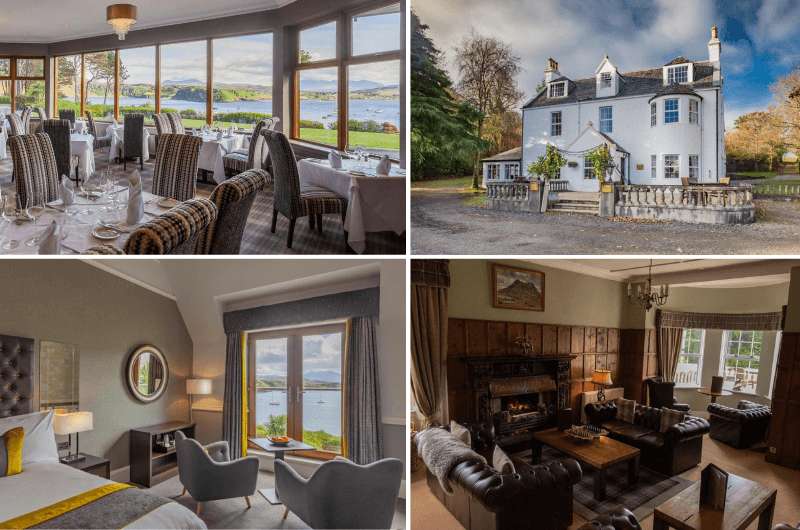
Cuillin Hills Hotel in Portree on the left and Greshornish House Hotel near Dunvegan on the right
You’ll be spending the following two days and two nights on the magnificent Isle of Skye.
The itinerary will be split up into a day for the north and a day for the south, so I think the best base is somewhat in the middle, in Portree. There’s also a wonderful hotel close to Dunvegan Castle, but its location will mean more driving.
The 4-star Cuillin Hills Hotel has views over Portree Bay and the mountains in the background and has a great restaurant where you can taste the award-winning whiskies.
Rooms are spacious and traditionally decorated with a modern touch and have large windows.
Prices from GBP 170 (USD 190) per night including breakfast.
Greshornish House Hotel is another 4-star hotel located a 25-minute drive west of Portree, near Dunvegan Castle. It’s a classic Scottish house with garden and lake views.
There’s a welcoming sitting area with a fireplace for those chilly evenings, and a wonderful breakfast room and outdoor sitting area, too.
Prices from GBP 130 (USD 150) per night including breakfast.
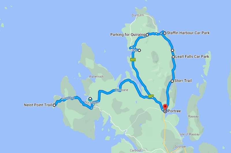
Day 4 itinerary on Google Maps
Total driving distance: 165 km (102 miles), starting and ending in Portree
Time needed: 12 hours plus food stops, save 2.5 hours if you skip the optional stops
Stops on day 4: Old Man of Storr, Lealt Falls, Brother’s Point, Kilt Rock, An Corran Beach, Quiraing Walk, Fairy Glen, Dunvegan Castle gardens, Coral Beach, Neist Point Lighthouse
Restaurant tip: Scorrybreac Restaurant in Portree | The Galley Café near Fairy Glen
Hotel recommendations: Cuillin Hills Hotel in Portree
Further reading: Best Places on the Isle of Skye
You will be starting and ending the day at your hotel in the northern part of the Isle of Skye, and it’s going to be a loooong day!
Today you’ll be driving on one of the most beautiful scenic roads in Scotland, the A855. The road itself is only 55 km (33 miles) long, but it’ll it’s where Isle of Skye’s highlights lie, so it’ll take you hours to get through it.
You’ll then head out to the westernmost point of the Isle of Skye and end your day with a spectacular sunset at the lighthouse.
You can skip over some stops if you aren’t up for such a packed day. I’ve also marked a couple of places as optional in case you can’t decide what to leave out.
Note: In case you’ve seen my Isle of Skye Itinerary, note that I used the exact same route in this Highlands itinerary.
Be prepared for driving on a sometimes shared-lane road, meaning you’ll need to be patient and stop and let cars pass from time to time. These types of roads are pretty common on Isle of Skye, so you’d better get the hang of it quickly. This is no highway!
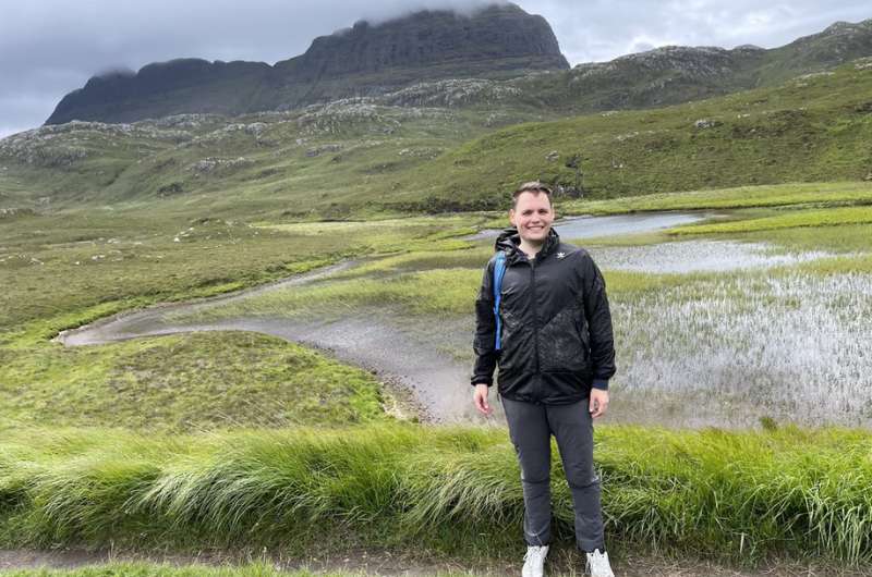
The giant’s thumb on the left, and Karin on the right
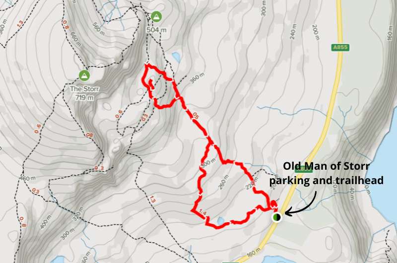
Distance from Portree: 15 minutes/11 km/7 miles
Time spent here: 2 hours
Parking and starting point: Old Man of Storr Parking Lot
The first place of touristic interest you’ll pass on the way up A855 from Portree is Bride’s Veil Falls, but they are really small, and you don’t have time to waste, so I say skip them.
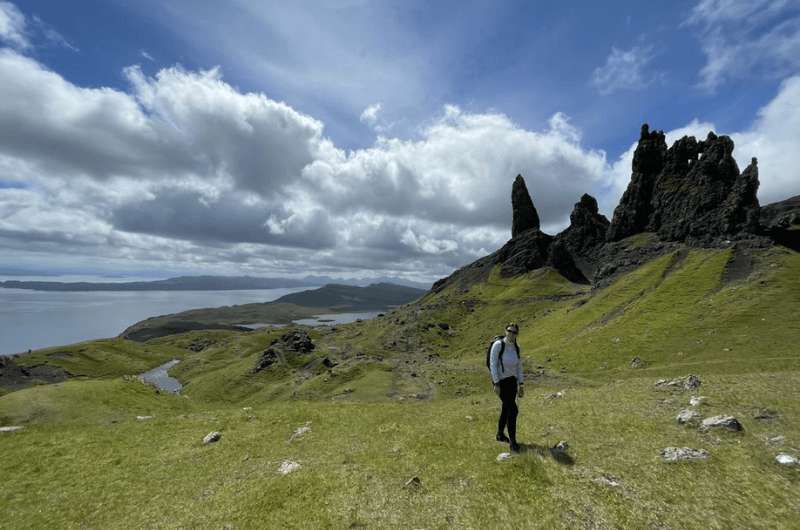
Instead, hightail it to one of the highlights of the Isle of Skye, the Old Man of Storr walk. One of the famous Skye walks is full of classic Scottish views of green mountains, lochs and rugged rocks. And a giant’s thumb protruding from the ground.
The Old Man of Storr walk takes about 2 hours to complete. It’s a 4.7 km (3-mile) circular hike with around 350 m (1100 ft) elevation gain.
Old Man of Storr walk map, details @ Alltrails.com
Google Maps does a great job of showing the parking lot and the trailhead, which are right next to each other.
Parking costs GBP 3 for 3 hours. If the parking lot is full by the time you get there, you can park on the side of the road closest to it. Don’t worry, you’ll see what I mean and certainly won’t be the only one.
Fun fact: The 2012 movie Prometheus was shot at Old Man of Storr.
Details about this hike in our article about the best hikes on the Isle of Skye.
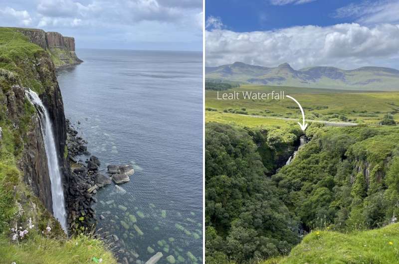
The waterfall on the left is at Kilt Rock, and the right photo is of the almost invisible Lealt Falls
Distance from last stop: 8 mins/8 km/5 miles
Time spent here: 2 hours
Parking: Lealt Falls Parking Lot
Lealt Falls is only a 10–15-minute stop, but it’s a must-see for the views (not so much for the falls).
It takes no effort as the viewing platform is just a few steps away from the tiny parking lot (which is free). The waterfall is nice, but nothing that special. The view overall is way better.
There’s also a little side trail that you can walk on for a few minutes to get wonderful views of the coast.
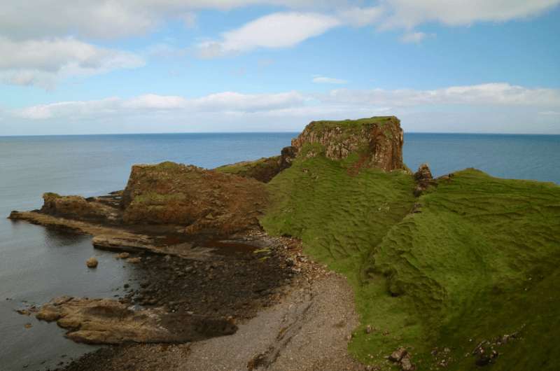
Brother’s point
Distance from last stop: 3 mins/2.5 km/1.5 miles
Time spent here: 20 minutes
Parking: Brother's Point Parking Lot
Just a couple of minutes from Lealt Falls is another quick stop called Brother’s Point. It’s a viewpoint with views out to the sea that you can see in 20 minutes max.
It’s special because somehow a lot of people skip it, so it’s one of the only places on your Isle of Skye itinerary that you might even end up being alone, bar the sheep (and large amounts of sheep shit).
Look for the sign right off the parking lot (free) and follow the (sometimes hard-to-see) trail. It’s only a short walk to the viewpoint.
Beauty in all directions @ Kilt Rock
Distance from last stop: 3 mins/3 km/2 miles
Time spent here: 10 minutes
Parking: By the Black Sheep food truck
Kilt Rock is a 10-minute stop. It’s an observation point where you can see the basalt columns over the sea and waterfalls, also over the sea. The parking lot is about 2 steps away from the viewpoint, which makes it a super easy stop.
Google Maps doesn’t show the parking lot, but it does show the food truck that is stationed on the parking lot, so head towards that. You might need to wait for a spot.
You’d think these views would be getting old by now, but no. Still spectacular. Also, you might be lucky and see a whale or two!
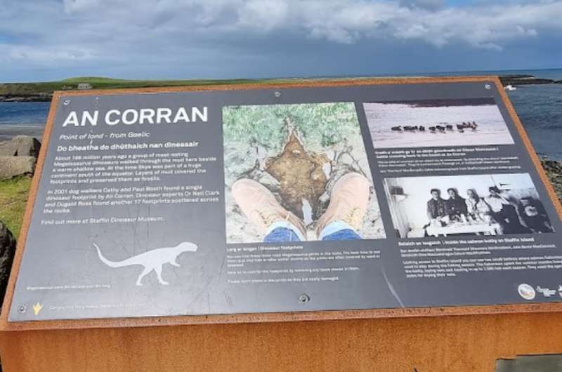
Dinosaur footprints at An Corran Beach
Distance from last stop: 5 mins/5.5 km/3.5 miles
Time spent here: 15 minutes
Parking: Staffin Harbour Car Park
An Corran is a beach whose main claim to fame, besides the omnipresent great views, is the presence of dinosaur footprints in the rocks. There’s supposed to be 19 of them in total, but they aren’t easy to spot, and if you’re there at high tide, you might not see any at all. Good luck on your Jurassic hunt!
Note that the last portion of the road to An Corran is a single lane, so patience is needed. It gets very busy in the summer. There is a parking area at the end of the road (free). Lots of campervans, too, so you may need to up your driving skills to fit into some places.
Depending on how much perseverance you have and how many footprints you set out to find, you could spend 15 minutes to infinity at An Corran.
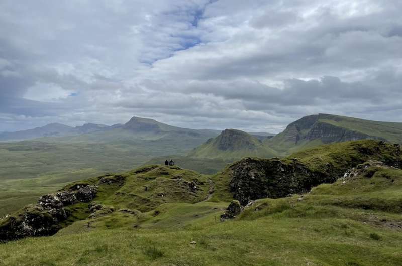
The amazing scenery on the Quiraing Walk, one of three highlights of your first day on the Isle of Skye
Distance from last stop: 15 mins/7 km/4 miles
Time spent here: 2.5 hours
Parking and trailhead: Google Maps link
Hike length: 6 km (12.5 miles) out and back
Difficulty level: Moderate
The Quiraing Walk is the highlight of the Isle of Skye, together with Old Man of Storr and Neist Point, so you should be really excited about this stop!
There is no landscape more Scottish than this. What you see during the Quiraing Walk is what you imagine when you hear the name Scotland—epic, grassy cliffs that dramatically tower up over the sea, getting lost in the clouds.
The views start right at the parking lot and never end. The actual Quiraing Rocks are near the end of the 2-hour circuit walk and aren’t the highlight. It’s one of those spots where the journey is the destination and just being there and seeing the scenery is what it’s about. It’s spectacular.
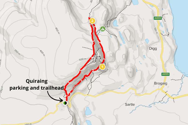
Map of Quiraing Circuit, details on Alltrails.com
You can also opt for the shorter Prison walk, which is 1 hour there and back—basically just the end of the circular walk.
Google Maps takes you right to the trailhead. There is a parking lot right there at the start, too, and it costs GBP 3 for 3 hours or GBP 5 for 6 hours.
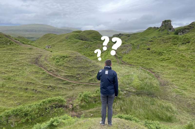
Make sure you dress for bad weather even if it looks like nice weather, and don’t go if it’s raining. That could be dangerous. Some areas of the trail get extremely muddy, are steep, and it just won’t be a nice experience if you’re scared you won’t make it.
More details about the Quiraing Walk and the different trails in our best hikes on the Isle of Skye article.
I just didn’t get the fascination with Fairy Glen
Distance from last stop: 20 mins/11.5 km/7 miles
Time spent here: 30–60 minutes
Parking: Fairy Glen parking, or in Uig if it’s full
I’m only describing this stop because I know you won’t trust me when I say you can skip it. I thought it was a meaningless stop. We could’ve saved precious time if we’d just driven right past.
Fairy Glen is a valley full of little bumps and rolling hills that looks like fairies would have a blast on. There are some legends about this apparently “otherworldly landscape” that I just didn’t appreciate for some reason.
The parking lot only holds around 20 cars (and costs GBP 5). If you can’t find a spot there, you’ll need to drive to Uig and park there, which would add 1.5 km (1 mile) to your walk.
From the parking lot, you walk maybe 10 minutes before you get to Castle Ewen, which is where you’ll get your first proper glimpse of the glen. You can then wander around until you’re satiated and then head back to the car.

Map of Fairy Glen access
You’ll need a maximum of 30 minutes if you’re like us and maybe an hour if you actually enjoy the place.
There’s no entrance fee to Fairy Glen.
Tip: There’s a cute little eatery close to the Fairy Glen stop called The Galley Café. They make wonderful seafood. There’s seating outside and inside, and it makes for a great stop before you head on to your next stop on the itinerary.
The Dunvegan Gardens are better than the castle interior
Distance from last stop: 40 mins/48 km/30 miles
Time spent here: 1 hour
Parking: Public parking lot
I intentionally call this stop Dunvegan Castle Gardens because I recommend skipping the interior of the castle. It’s just nothing that special, and the gardens are considerably more worth your time. If you look at the ticket price, you’ll see that even the owners agree (you only save GBP 2 if you buy a ticket for just the gardens).
The gardens and the castle exterior are fantastic. The gardens reminded me of Olympic National Park in Washington, DC. Take at least an hour to look around.
Parking is free in a parking lot not far away from the castle.
You can also make a quick stop at a viewpoint close by that’s on the way to the next stop on this itinerary, Coral Beach.
More details about our Dunvegan Castle visit are in our top things to do on the Isle of Skye article.
Coral Beach and the coral on the beach
Distance from last stop: 15 mins/5.5 km/3.5 miles
Time spent here: 1 hour
Parking: Coral Beach parking lot
You probably didn’t expect there to be so many beach stops in the Highlands, did you?
Coral Beach is a 10-minute drive north of Dunvegan Castle. Once you leave your car at the parking lot, it’s about a 2 km (1.2 mile) easy walk to the beach (about 20 minutes).
It’s a beach, but somehow more special. Like everything else on the Isle of Skye. What looks like white sand is made of itty bitty bits of coral (don’t take them home as souvenirs!), hence the name.
There are nice views of the shore and the walk is pleasant. You might even meet a cow. It gets very windy.
Neist Point Lighthouse waaaay in the back
Distance from last stop: 50 mins/25 km/15.5 miles
Time spent here: 2 hours
Parking: Neist Point parking lot
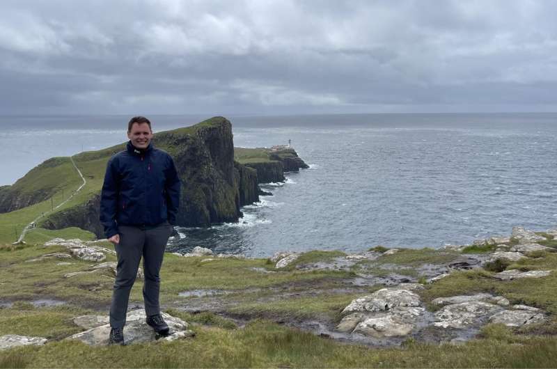
Neist Point Lighthouse is the westernmost point of the Isle of Skye, which protrudes so dramatically into the sea.
Just to be clear, it’s not the lighthouse that you come here for, it’s the scenery. The lighthouse is just there to look pretty in pictures; you can’t even visit it. It’s just an extremely picturesque place, especially at sunset.
Prepare for a tricky drive on shared-lane roads to get to the parking lot , which is right where the trail starts.
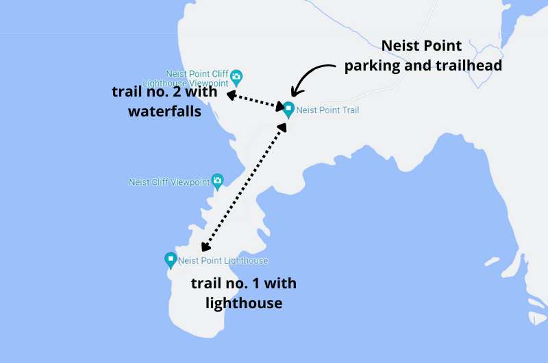
Don’t forget to go down the other trail as well! Click through to Google Maps.
There are two trails from the parking lot: one down to the lighthouse and one to the right (when facing the lighthouse) that takes you to some more coastal scenery, complete with waterfalls.
It’s common to spot whales and dolphins from the cliffs, so keep an eye out!
You will spend about 2 hours walking around. That said, you can walk to the lighthouse in about 20 minutes, so it’s not so much a long distance as it is photo op after photo op of the incredible landscape.
The drive back to Portree from Neist Point takes about an hour (or only half the time if you choose to stay at Greshornish House Hotel.
Day 5 itinerary on Google Maps
Total driving distance: 250 km (155 miles), start in Portree, end in Fort William
Time needed: 8 hours hours plus food stops (without Cuillin Hills hike)
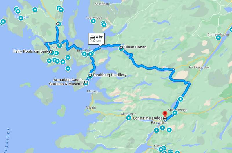
Stops on day 5: Fairy Pools, optional hike in Cuillin Hills, Torabhaig Distillery, Armadale Caste, Eilean Donan Castle
Restaurant tips: Lean to Coffee | Deli Gasta | Red Skye Restaurant
Hotel recommendation: Old Pines Hotel & Restaurant|
Further reading: Best Places on Isle of Skye | Best Hikes on Isle of Skye
What the fairy pools can look like if you have good weather (we didn’t)
Distance from Portree: 30 minutes/33 km/20 miles
Time spent here: 1–2 hours
Parking and starting point: Fairy Pools Parking Lot
The Fairy Pools are an area of little streams and pools of water and a small waterfall here and there that can look magical in photos against the dramatic rocks in the background. This is only true in good weather when the rocks aren’t all covered in clouds like they were when we went. I’ve borrowed some photos from the interwebs for the title photo, because my photos don’t do the place justice.
Just know that the pools themselves are just ok, you have to look at the big picture to see why the place is so special. Now this feels like a fairies could live here.
Be prepared for crowds. Coming from Drynoch, you’ll be driving on a shared-lane road for the last 10 km (6 miles) before you get to the parking lot, so be patient—it could take a while. Parking at the Fairy Pools costs GBP 6.
From the parking lot, it’ll take about 20 minutes to walk to the Fairy Pools, then you can wander around for a bit and head back. About 1 hour total time.
There’s also a loop trail that’s about 5 km long and it takes about 2 hours to complete. The Fairy Pools are surrounded by some of the peaks of the Cuillin Hills, so you’ll get some great views of those as well. This could be a good option if you want to see more nature but aren’t planning on going on a Cuillin Hills hike (see next item).
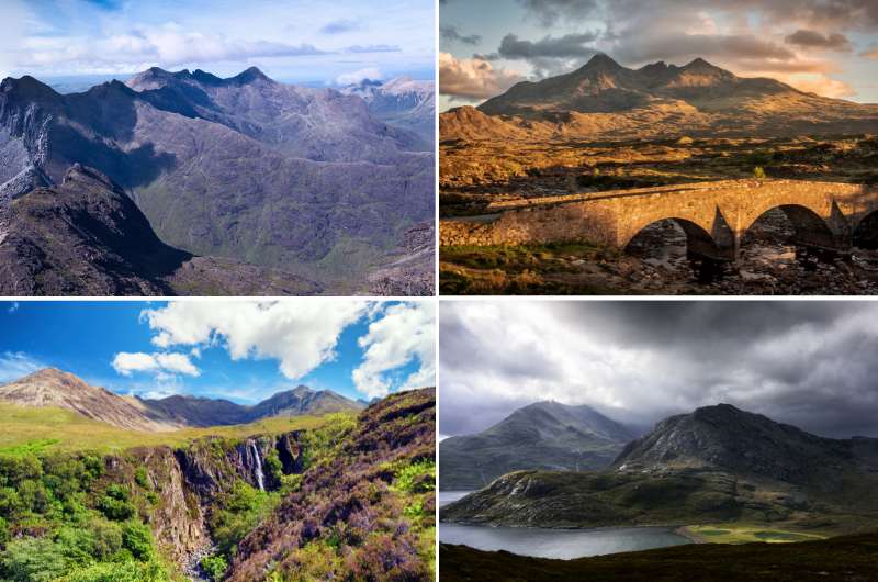
An assortment of Cuillin Hills views
If you’re keen on more hiking, go on a proper hike! We have an article on the best hikes on the Isle of Skye. It would mean a longer day and potentially leaving some other stuff from the itinerary out, but it’s a way tailor these plans to your needs.
The Cuillin is a famous mountain range in the south-central part of the Isle of Skye. It’s also the most challenging mountain range in the UK, though there are some easier walks that the less ambitious folks can go on.
There are many hikes or varying difficulty and length to choose from. You can use alltrails.com (no affiliation) to check out the various routes. Or just trust us to pick the best ones. Head over to our best hikes in Isle of Skye article for details on those.
Most hiking options start in one of two spots: the majority Sligachan, like to the peak of Bruach na Frithe, or the flat walk to Sgurr Na Stri, both done in 6–8 hours. Some hikes start at the Glenbrittle campsite., like to Cuillin’s highest peak, Sgùrr Alasdair (6 hours) or to Coire Lagan (a mountain lake), a short hike that you can do in 2 hours.
Glenbrittle is only an extra 10-minute drive from the Fairy Pools parking lot, so it’s easy to add on right after or before the Fairy Pools.
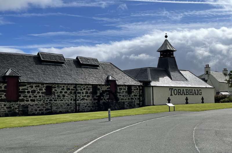
Torabhaig Distillery
Distance from Fairy Pools: 1 hour/62 km/40 miles
Time spent here: 1.5 hours
Parking: At the distillery
Very much unlike our despicable experience at the Edinburgh Gin Distillery in Edinburgh, this tour was very informative and everyone we met there, from the distillers to the lovely woman at the gift shop, was amazingly welcoming. We loved it there.
Tip: Some of our favorite restaurants on the Isle of Skye are clustered around the halfway point from the Fairy Pools to the Torabhaig Distillery. Lean to Coffee, Deli Gasta , and the uber-fantastic Red Skye Restaurant will cover you no matter what your food needs are. A quick bite? Sure. A sit-down meal? Yes! Coffee? Check!
The distillery tour takes about an hour, but leave time for some gift shop mayhem and also to enjoy the wonderful scenery.
There is sufficient free parking right at the distillery.
The tours at Torabhaig Distillery get sold out, so make sure to plan accordingly and choose your time slot at least a couple of weeks beforehand.
If you want to learn more about the tour and a little bit about the slightly racist man that founded the place, read our top places on Isle of Skye article.
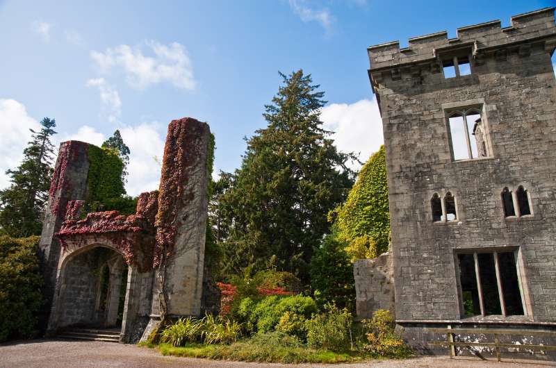
Armadale Castle is best if you visit on a sunny day
Distance from last stop: 10 mins/5.5 km/3.5 miles
Time spent here: 1 hour
Armadale Castle is a ruin that sits right on the coast, with fabulous views to Scotland’s mainland just across the loch (or is it the sea at this point?!). Try to go on a sunny day to appreciate the views, there aren’t many places to hide from the elements at Armadale.
Parking is free.
An exception is the small, award-winning museum attached. It’s very informative and tells the history of the Highlands and islands through the story of Scotland’s most powerful clan, Clan Donald.
There are also two cafés on site, one indoor and one outdoor.
If you can’t get enough of the views, check out this nearby viewpoint.
Armadale’s tourist season ends in October, as it does in a lot of Scotland’s castles.
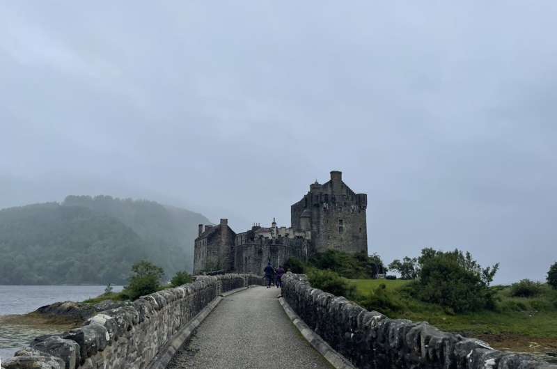
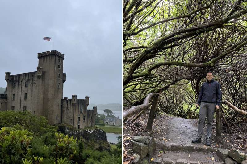
Eilean Donan rightfully earned its place on our best castles in Scotland list
Distance from Fairy Pools: 45 minutes/48 km/30 miles
Time spent here: 2 hours
Parking: At the Eilean Donan parking lot
I have a personal bias towards Eilean Donan, because it’s the castle from my favorite B-rated 80s action movie, Highlander. I was so excited to visit this place, and it delivered!
It’s located on a tiny islet of its own, just a short walking bridge away from the mainland. Sometimes there is almost no water around it, but if you are lucky and manage to see it when the little island is actually an island, it’s magic!
Eilean Donan Castle was originally built to protect the area against Vikings, because it is in a strategic location at the meeting point of 3 lochs/fjords. The castle was destroyed in 1719, lied abandoned for 200 years, and then bought and rebuilt by John MacRae-Gilstrap in 1912. The current owner is a descendant of John’s, is 94 years old and still uses it as a holiday home.
Make sure to set your navigation to Eilean Donan Castle, not just Eilean Donan, or you’ll end up in all the wrong places like we did.
There is a parking lot right before the small bridge to the castle. Parking is GBP 2 per hour.
Allow 2 hours to visit. It’s a self-guided tour with guides on hand if you are extra interested in any info. You don’t need to book tickets to the castle ahead of time, just rock up and in you go.
You can spend some time in the visitor center, gift shop and onsite café, as well.
Don’t forget to visit the viewpoint above the castle. You can drive or walk there (on the road). See above photo to see what the view is like (the one with me, Jan, in it).
Note: Eilean Donan is closed when it hosts weddings (which is does a lot of). You can check wedding days on their website.
The drive from Eilean Donan Castle to Fort William, where you’ll be basing yourself for the next 2 or 3 nights, takes 1.5 hours (105 km/65 miles).
Read our article about the best castles in Scotland for more details.
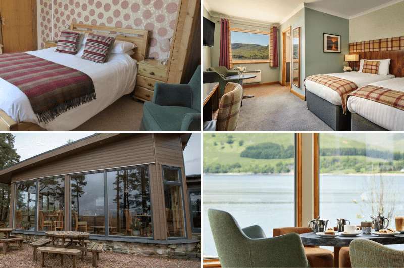
The best places to stay in Fort William: Old Pines Hotel & Restaurant on the left, Clan Macduff Hotel on the right
You will be changing hotels after your second day on the Isle of Skye. Choose a hotel in Fort William for the best base for your Glencoe exploration.
We would stay at Old Pines Hotel & Restaurant, because the restaurant is absolutely incredible and the hotel is excellent value. Both the restaurant and some of the rooms have views of the highest peak in the UK (and one of the best places for a hike in Scotland!), Ben Nevis.
Prices start at GBP 120 for 2 people per night with breakfast.
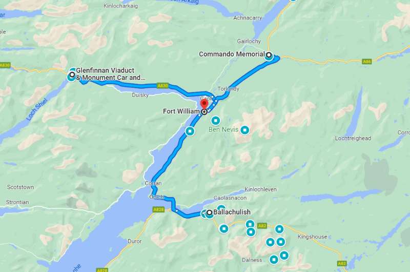
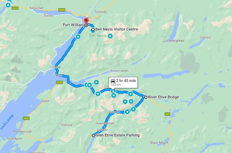
Day 6 itinerary on Google Maps
Total driving distance: 135 km (80 miles), start and end in Fort William
Time needed: 8 hours plus food stops
Stops on day 6: Glenfinnan Viaduct, Commando Memorial, Pap of Glencoe
Restaurant tips: Old Pines Hotel & Restaurant | The Geographer (both in Fort William)
Hotel recommendations: Old Pines Hotel & Restaurant|
Further reading: Glencoe Highlights
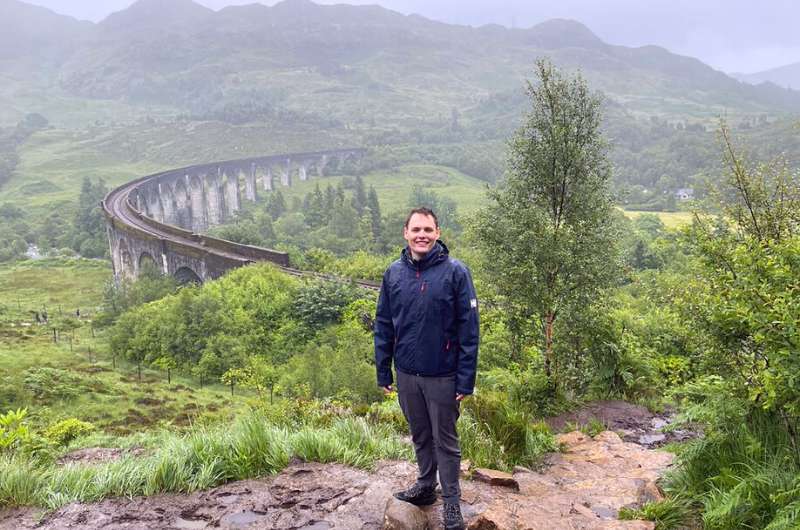
Glenfinnan Viaduct
Distance from Fort William: 30 minutes/27 km/16 miles
Time spent here: 2–3 hours
Parking: At the Glenfinnan Viaduct parking lot
Glenfinnan Viaduct is a 120+ year old railway viaduct on the West Highland Line. It is the longest concrete bridge in Scotland, measuring 380 m (1250 ft). It is single track and it has views to Lock Shiel and the Glenfinnan Monument.
For us, one of the best places to visit in all of Scotland.
Even though the Glenfinnan Viaduct featured in several movies (and a video game!), it gained the most fame when it featured in several Harry Potter movies.
Besides the viaduct, you can visit the visitor center, the Glenfinnan Monument, and check out Loch Shiel. All in all, put aside 2–3 hours for the entire visit.
The parking lot is huge, but so are the crowds, especially before train crossings. Parking costs GBP 3.50. We saw a couple of other smaller parking lots close by that could save you in a pinch.
If you want to get the most out of you Glenfinnan Viaduct visit, time your trip so that you are there when the train goes across the bridge. A steam train crosses the Glenfinnan Viaduct twice a day—at 10:45 am and 3 pm, and it is well worth being there for the crossing.
Get there early, since parking can take a minute and then there’s about a 10-minute walk from the parking lot to the viaduct.
There’s a 3.5 km (2 mile) circular trail that you should definitely spend the hour or so walking. The parts further up look like they could be from the Lord of the Rings. The trail takes you past awesome viewpoints of the viaduct and of Loch Shiel, and the Glenfinnan Monument is just off it close to the parking lot.
The visitor center is right by the main parking lot, and I think it’s worth visiting to get an understanding of the Jacobite uprising, which was a huge event in Scottish history. It’s free to enter and is open daily from 10 am to 5 pm for most of the year. There’s a café attached, too.
You can climb up the Glenfinnan Monument for some pretty views over the lake and the surrounding landscape.
You can book your ticket in advance if you really want to be able to climb the monument, since it’s only open for a very short time each day. Honestly I think it’s nice even just looking at it from the ground. Tickets cost GBP 5 per adult (discounts available).
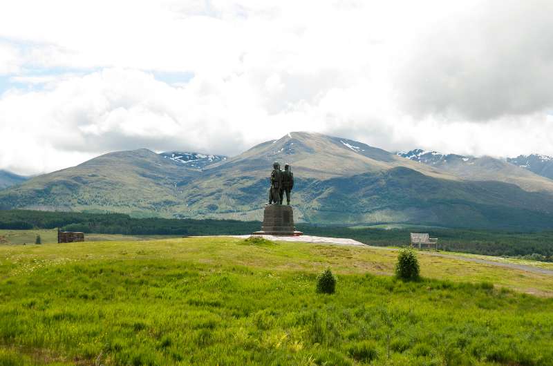
Commando Memorial
Distance from last stop: 35 minutes/38 km/23 miles
Time spent here: 30–60 minutes
Parking: At the Commando Memorial parking lot
The Commando Memorial is a bronze statue of 3 army men dedicated to the British Commando Forces that fought during World War II. It was unveiled in 1952 and is one of Scotland’s busiest memorial sites—busloads of people come to see it daily.
It’s popular not just because of the memorial itself, but also because of the views surrounding it. In good weather, you can even see Ben Nevis. The memorial overlooks the former training ground of the soldiers.
Besides the statue, a circular Garden of Remembrance sits nearby, with individual plaques of soldiers that have died in later years—either WWII veterans, or those that fell in more recent conflicts.
It’s a beautiful place that is easy to visit. Parking is free and is right next to the Commando Memorial.
Several hikes start from the memorial, so it’s easy to add a nice walk onto this stop if you have time.
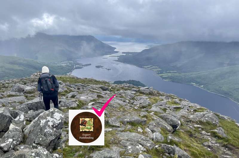
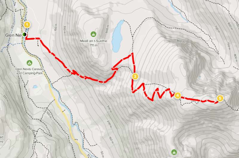
Pap of Glencoe, possible thanks to pathfinder skill
Distance from last stop: 45 minutes/43 km/27 miles
Time spent here: 3–4 hours
Parking: Google Maps link to where you can leave your car
Starting point: Google Maps link to trailhead (go through the gate)
Hike length: About 5 km (3 miles) out and back depending on the trail you choose
Difficulty level: Hard
Known as Sgòrr na Cìche in Gaelic, the Pap of Glencoe hike felt really hard because of the path—it’s either muddy (even in sunny weather!) or super rocky the whole time. Any Heroes 3 fans out there? You need the pathfinder skill to get to the Pap of Glencoe!
It took us 2 hours up and about 1.5 hours to get back down. I definitely wouldn’t take kids or dogs on this trail. Do wear proper footwear.
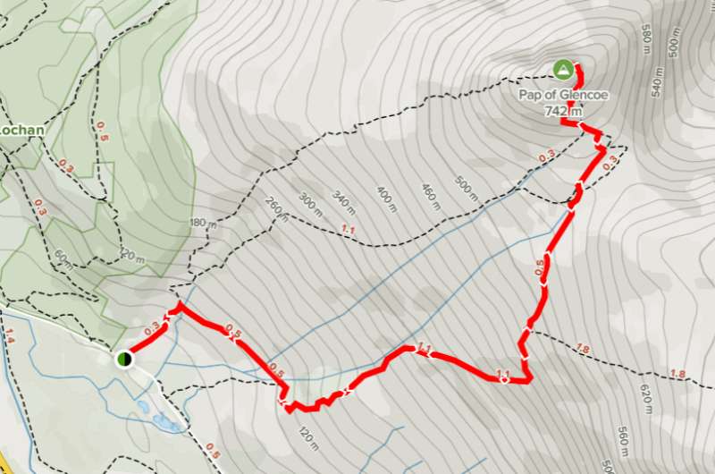
One of the possible ways to hike up the Pap of Glencoe. Details of this hike on Alltrails.com
We really enjoyed the views from Pap of Glencoe, but honestly, the last 100 m-high mound is not worth the extra effort to scramble up. You are already getting the best views when you’re right under it, so unless you are set on summiting, you can turn back without getting all the way to the end.
This hike’s parking area is not visible on Google Maps. You can see the place where you can leave your car here. It’s about 300 m (980 ft) from the trailhead. If it’s full, you need to park in Glencoe and walk the extra 1.5 km (1 mile) to the trailhead.
Speaking of which, the trailhead to Pap of Glencoe also isn’t on Google Maps. Here’s where it starts (close to Strath Lodge). You’ll have to walk through a gate to start, and then it’s just straight up the mountain. There are several trails up, so decide what you want to do beforehand. Alltrails has details on one of the paths here, another trail is here (see just the first half).
After the hike, drive 30 minutes back to For William for the night. Tomorrow’s your last day in the Scottish Highlands!
Day 7 itinerary on Google Maps
Total driving distance: 135 km (84 miles), start and end in Fort William
Time needed: 11 hours plus food stops
Stops on day 7: Ben Nevis hike, James Bond Road
Restaurant tips: Old Pines Hotel & Restaurant | The Geographer (both in Fort William)
Hotel recommendations: Old Pines Hotel & Restaurant|
Further reading: 10-day Scotland Itinerary
Ben Nevis
Distance from last stop: 45 minutes/43 km/27 miles
Time spent here: 7–9 hours
Parking and starting point: Ben Nevis Visitor Center
Hike length: 15 km (3 miles) out and back
Difficulty level: Hard
Ben Nevis aka The Ben is Scotland’s iconic mountain and the highest peak in the UK at 1345 m (4412 ft).
Climbing it takes the better part of a day, but it can be done by beginners.
You’ll be starting almost at sea level, so the elevation gain is significant. The first half is a walk up a mostly stony or gravel-y trail, and the second half is a zig-zag rocky trail that’ll have you unsure whether to look under your feet trying not to trip, or at the awesome views.
Remember it is always necessary to have a map, a compass, and good clothing—Scotland’s weather changes its mind very frequently and you don’t want to get lost. There is no signposting on the trail, though it is mostly easy to see. About 1000 people go on the Ben Nevis Walk every day in the summer months, so you won’t be alone.
Trail details on Alltrails.com
You’ll get all the information you need at the Ben Nevis Visitor Center near For William, which is also where you’ll start your hike.
There’s easy parking at the visitor center.
Walking up Ben Nevis makes sense mainly in good weather, because if you have to hike through clouds, you’ll see diddly squat at the summit. A good app for weather is AccuWeather, or you can check the latest forecast at the Mountain Weather Service website.
Tip: When you summit Ben, you can cross off your first Munro and take up a new pastime—Munro baggin! If you want to know why you are now baggin’ things and why it’s a popular hobby for the British, check out our Scottish fun facts.
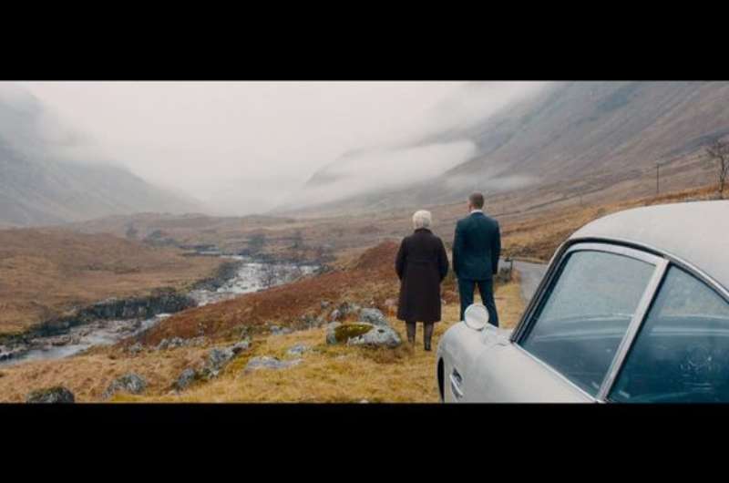
Scene from Skyfall...
...scene from real life
Distance from last stop: 20 minutes/20 km/12 miles
Time spent here: 1.5 hours
Scenic road starting point: Near the River Etive Bridge
Scenic road length: 20 km/12.5 miles
James Bond Road, famous for being featured in the 2012 James Bond movie, Skyfall, is a scenic road of 20 km (12.5 miles) between the A82 and Loch Etive.
It’s easy to navigate, but it is single lane, so be prepared for it to take time to drive through while letting others pass or stop to take photos. You then need to drive the same way back again, so don’t hurry and just take in the magnificent views of Glen Etive.
There are spots on the way where people stop and take photos of the most beautiful and famous parts. If you do this (you will want to), just keep traffic moving and don’t linger too long. Sometimes there’s only room for one car, so take your pic and get out of there.
Tip: Do you love scenic roads? Check out our tips for driving in Scotland which include how and where to drive.
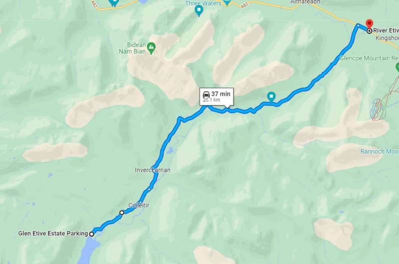
James Bond Road on Google Maps
Once you finish the Ben Nevis hike, you’ll be just about ready for dinner, wine and lots of sitting and resting. You can relax at your hotel in Fort William, which is about 45 minutes away, or you can push onward and head to your next destination. Edinburgh perhaps?
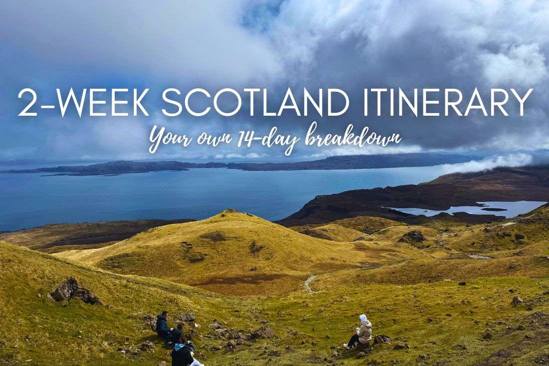
Read our 10-day Scotland Itinerary to get inspired for a longer trip.
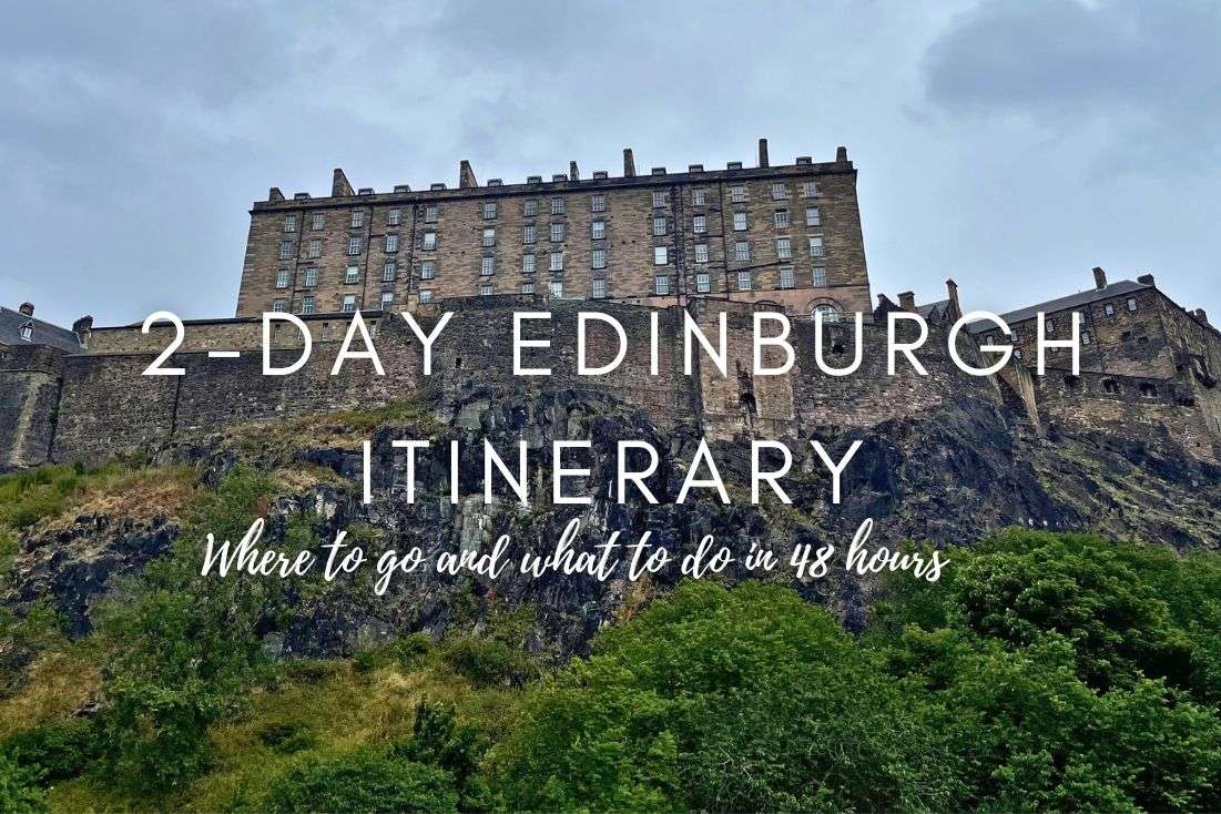
Here are the best things to do and see in Edinburgh.
Scotland is beautiful but the weather is unpredictable. Make sure you’re ready!
We visited in July and still got snow, so it’s obvious you want to avoid visiting in the winter months! Many hiking paths aren’t even accessible and some tourist sights such as castles closing up completely in the winter.
Visit the Scottish Highlands between May and September for the best weather, but still prepare for the worst weather.
Luck favors the prepared!
Bring proper clothing! Always expect rain, mud, and crazy wind that will creep into even the best of softshells.
We got snow in the middle of July. And when I say proper, waterproof gear. Not that stuff you can wear when you go on a little forest walk back home.
The advice I wish someone would’ve given me (and strongly insisted I take it) in preparation for a Highlands visit: Pack very good (!) waterproof clothing! We had to buy all new jackets and shoes in Scotland after the stuff we took was deemed utterly insufficient about 7 minutes into our trip. And we had good gear! Just not Scotland-ready gear. That’s a whole other level.
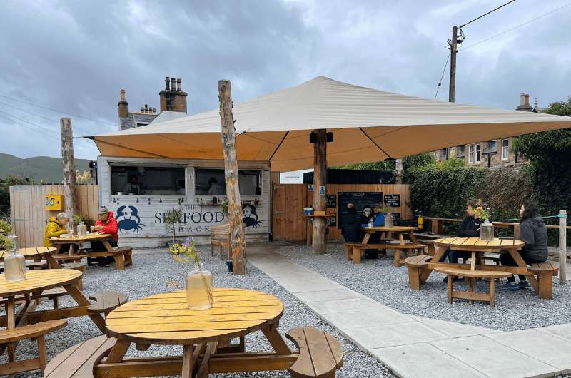
Seafood shack in Ullapool
Always book restaurants in the Scottish Highlands in advance. It might seem unnecessary, but trust me.
On the Isle of Skye there were so many visitors that we stopped at about 10 restaurants, not kidding, before we found a place to eat on our first day. We quickly learned our lesson and made restaurant booking for the next days.
Even in Assynt, which feels like the end of the Earth with nobody there, has restaurants that are full or tourists at all times. Book ahead!
You might also be interested in reading:
This post may contain affiliate links. We earn a small commission if you make bookings through my links, at no additional cost to you. This helps us keep this blog free, thank you!


Hi, I’m Jan. I travel fast and intensely, whether I’m exploring the buzz of Tokyo in 3 days or road-tripping through mountains and beaches on a 3-week Thailand adventure. And no matter where I am, you’ll always find me in a comfortable hotel at night and eating the best food.
If that sounds like your kind of journey, hop on board, and let’s explore the world together!
I started this blog after realizing how tough it can be to find reliable, authentic travel info. You wouldn’t believe how many “travel bloggers” never even visit the places they write about! On Next Level of Travel, you can count on my full honesty and insights drawn from my firsthand experiences.
Here’s the deal: not every destination is all superlatives and unicorns. I’ll let you know if a tourist attraction isn’t worth your time, like skipping overrated stops in my 2-week Spain itinerary. And when I find something truly special—like the perfect mix of culture and nature in Cape Town—you can trust that it’s worth adding to your itinerary.
Comments | Thoughts? Give us a shout!