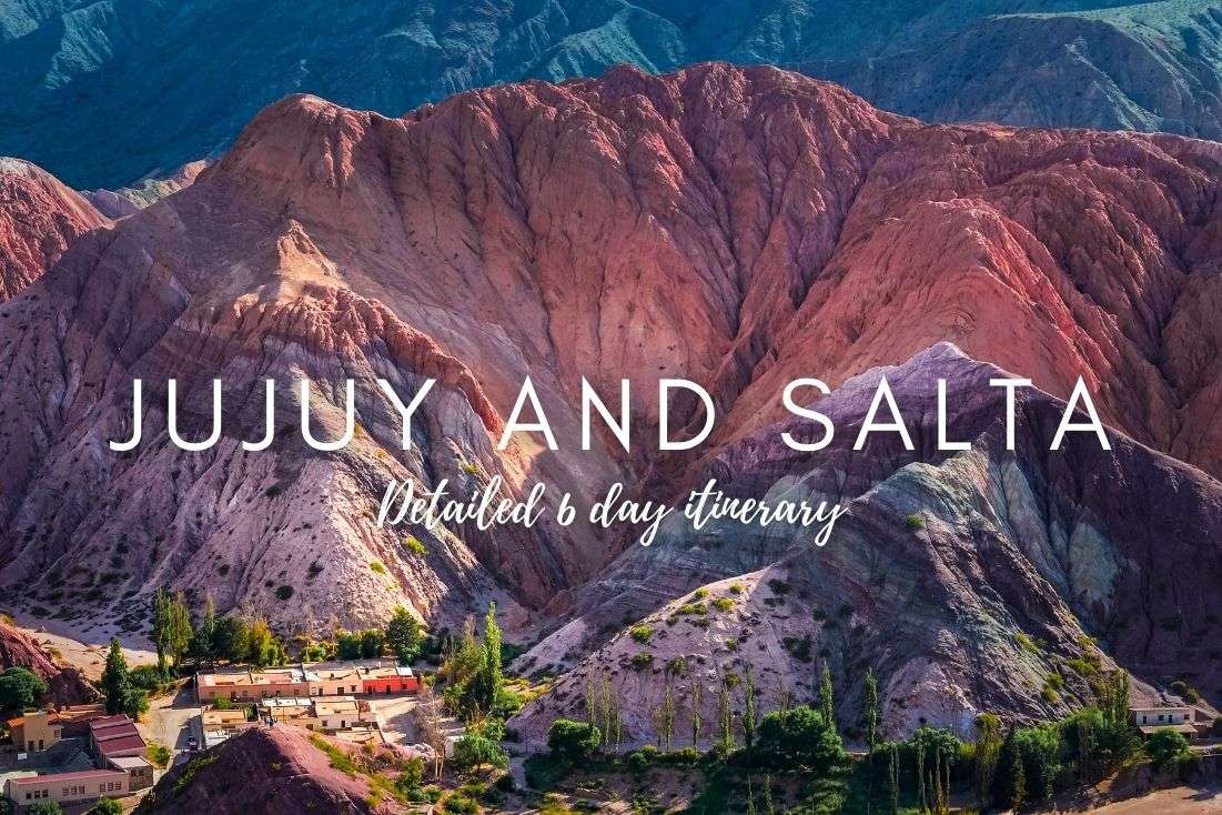

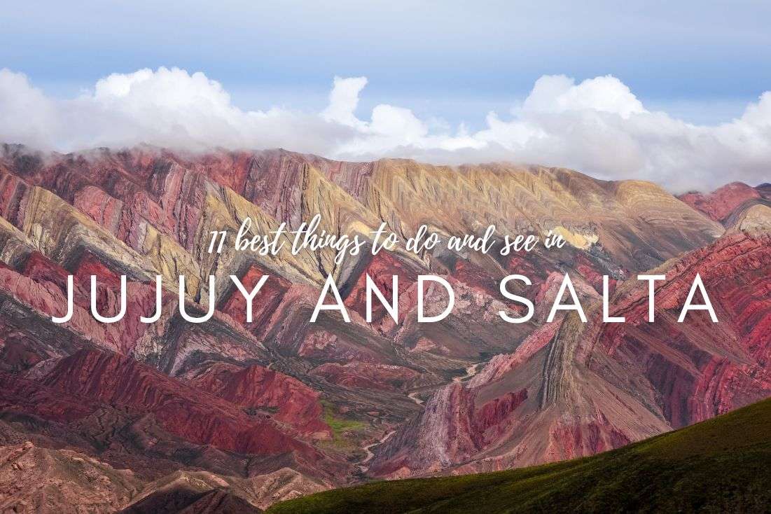
The provinces of Salta and Jujuy, tucked away in the northwest of Argentina, cover a vast area of about 209,000 km² (80,700 mi²). This region barely made it onto our travel radar, but I'm glad it did because it turned out to be Argentina's hidden gem. Sure, it's a vast area (too vast for it to actually be “hidden”, you’d have to be blind), and I'm certainly not the first tourist to discover it, but compared to Argentina's more famous spots like Buenos Aires, Iguazu Falls, or Patagonia, Salta and Jujuy are somewhat overlooked. Yet, they offer world-class natural attractions, not to mention their own version of the rainbow mountain, which is bigger and more colorful than Peru's.
It's a shame more people don't visit Salta and Jujuy, as these provinces offer unique sights not found elsewhere. There's enough here to fill a packed 7-day itinerary, which I've, of course, meticulously planned out for you. But honestly, I could easily spend even more time soaking in the beauty and depth of Salta and Jujuy.
Argentina is great! Get ready for 7 full days in Jujuy and Salta
Good to know before you go to Salta and Jujuy
Now, let's talk about your 6–7-day Salta & Jujuy itinerary, which I've laid out, including your arrival and departure days, to fit into a neat package. Of course, this depends on your flight times and where you're flying from. So, if you don't fancy exploring Salta like a zombie right after a long flight just because I said so, feel free to add a "day zero" to your trip.
Upon arrival, settle into your accommodation and perhaps venture out for a good dinner (good luck with that), and the next day, you're all set to uncover the wonders of Argentina.
Speaking of accommodation, if you want to ensure a comfortable stay after your flight, try the MG Design Hotel Boutique in Salta. It's centrally located, boasts modern amenities, spacious rooms, parking right in front, which is a blessing in the city center, and, of course, fantastic breakfast options.
Here’s how to plan the best 6–7 days in Salta and Jujuy:
(Day 0: Arrival + car rental)
Day 1: Explore Salta (sleep in Salta)
Day 2: Prepare your back for some serious driving—Cuesta del Obispo, Los Cardones National Park, Cachi, Quebradas de las Flechas (sleep in Salta)
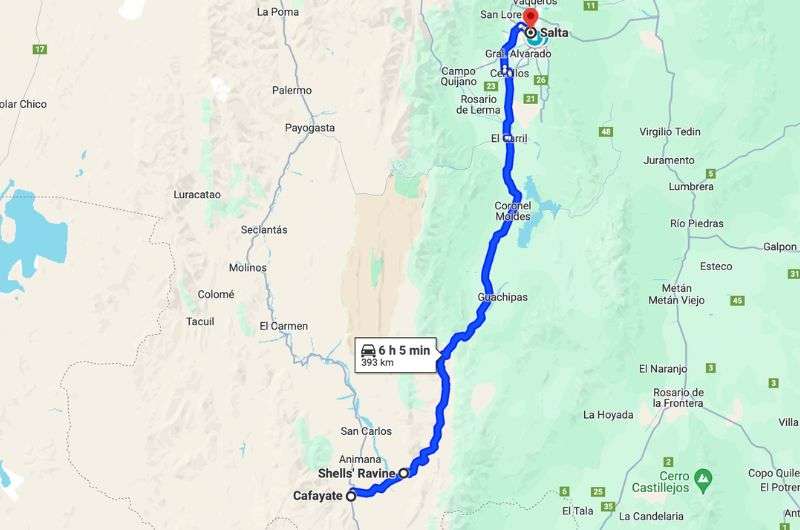
Day 3: Shells' Ravine and Cafayate wineries (sleep in Salta)
Day 4: Move to San Salvador de Jujuy and visiting Quebrada de Humahuaca (Cerro de los Siete Colores, Pucará de Tilcara, Garganta del Diablo, Quebradas de
las Señoritas, Mirador A la cercanía de los 14 Colores del Hornocal) (sleep in San Salvador de Jujuy)
Day 5: Calilegua NP and be stunned by a jungle where the most jaguars live (sleep in San Salvador de Jujuy)
Day 6: Salinas Grandes, then Salta and fly to your next destination
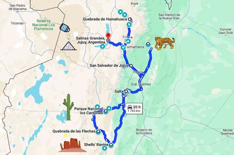
Our 6-day itinerary in Salta and Jujuy (see this map on Google Maps)
Time to dock in Salta
From Salta's Martín Miguel de Güemes International Airport to the city center is just a 20-minute drive—super easy. Plus, getting your luggage at Salta airport is ridiculously fast.
If you're as clever as we were, you'll have arranged a car rental in advance, and your car will be waiting right at the airport. I can personally vouch for CDO Rent a Car—everything went smoothly, and they were really eager to help.
First off, swap some "blue dollars." Head to the street to find the "arbolitos"—folks who trade on the black market but will give you about three times the official exchange rate for your US dollars. Sweet deal, right? Just be prepared to carry a backpack (for all the bills you’ll get).
You'll end up hauling around a ludicrous amount of cash. It's laughable, really. The currency system here is bonkers; you might want to exchange more, but tough luck, they're out of bills. Plus, a million might weigh around 0.5 kg (1 lb).
One more tip: I recommend paying for your accommodation in local currency, whether cash or card, to snag the best exchange rate.
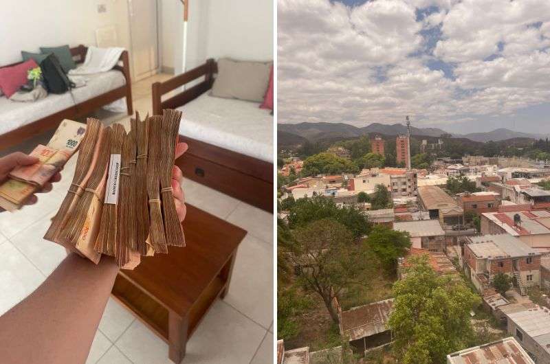
We're taking our stack of money and heading to Salta city centre!
Main sites visited on day 1: Museum of High Altitude Archaeology, Museo Guemes, Cathedral of Salta,Basilica Menor San Francisco, The San Bernardo Hill
Restaurant tips: La Salteñeria Empanadas
Hotel recommendations: MG Design Hotel Boutique
Further reading: 11 Amazing Things to Do and See in Jujuy and Salta
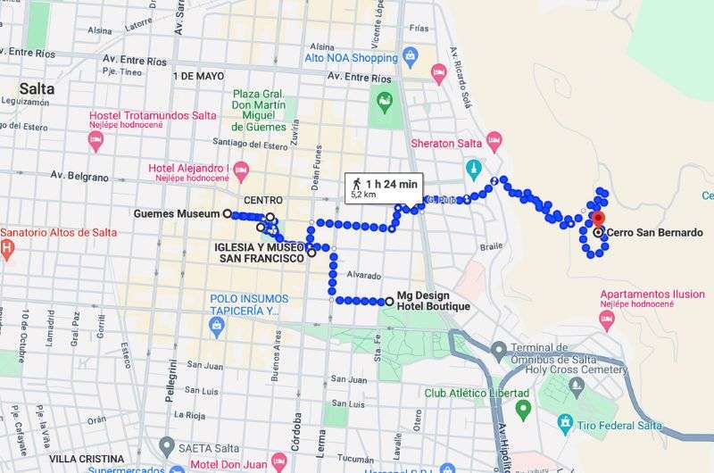
Taking it easy while exploring the city of Salta (see this map on Google Maps)
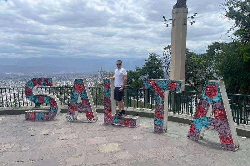
Salta is the capital city of the province with the same name, nestled in the Valle de Lerma. It's Argentina's 8th largest city, boasting a population of 554,000. Salta is situated 1,700 km (1,060 mi) from Argentina's capital, Buenos Aires. And as I mentioned before, Salta has its own airport, making flying here the easiest option.
There's not a ton to see in Salta (at least in my opinion). The city itself is pretty, but if you arrive on a morning flight, I reckon an afternoon will suffice to explore.
Museo de Arqueologia de Alta Montana de Salta
Distance from MG Design Hotel Boutique: 1 km (0.16mi), 15-minute walk
Time spent here: 1–2 hours
If you've read any of my other articles, you know I'm a museum fanatic. So, naturally, our first stop in Salta was at the MAAM—Museum of High Altitude Archaeology. This relatively new museum, opened in 2004, has one main mission: to showcase Argentina's most significant finds, including the best-preserved Inca mummies.
Discovered at an altitude of 6,793 m (22,287 ft), right below the mountain peak, this is, by the way, the highest archaeological site in the world. And who exactly did they find there? Besides a bunch of artifacts, they found the mummies of three children aged 6 to 7.
Mummified children, pretty intense, right? They were sacrificed around the year 1500 as part of ritual offerings to the gods. The ritual involved drugging the children with coca leaves and alcohol before killing them and burying them in a small chamber 1.5 m (5 ft) underground. To add a bit of chill to the tale, the mummies are displayed in freezers at the MAAM museum, which only adds to the overall morbidity.

The picture of Martin Miguel de Guemes in Museo GÜEMES
Distance from previous stop: 250 m (820 ft), 3-minute walk
Time spent here: 1–2 hours
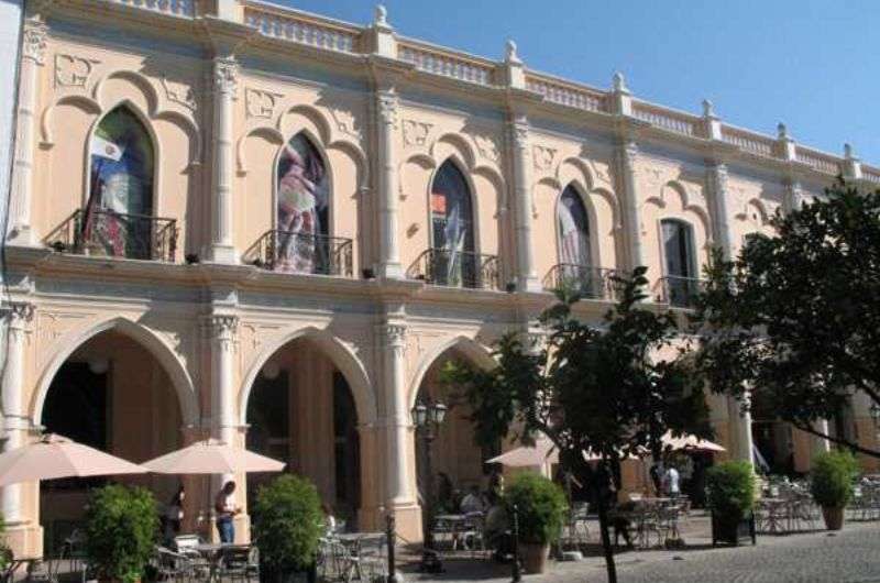
Are you a museum enthusiast like me? Awesome, then you should definitely check out the Museo Guemes—History Museum next door to the MAAM. This museum earned big points from me for its immersive visitor experience. Inside, there are QR codes scattered on the floor that reveal fun facts when scanned.
The museum is named after Martin Miguel de Guemes, a native of Salta and a 19th-century Argentine national hero who played a significant role in Argentina's war of independence. The museum offers insights not only into his life but also into the military campaigns and the broader historical context of Argentina's fight for freedom.
I’m a Barbie girl in a Barbie wooorld...okay, I’ll stop
Distance from previous stop: 230 m (750 ft), 3-minute walk
Time spent here: 20 min
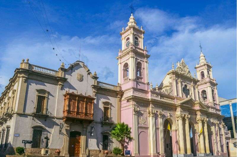
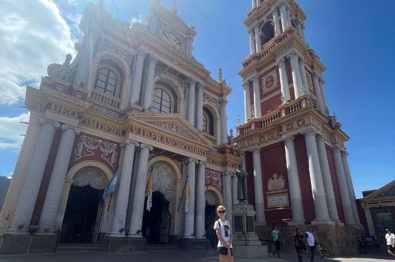
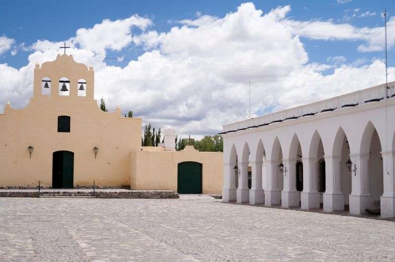
If Warner Bros. ever ran out of money for Barbie movie sets, they'd probably head to the Cathedral of Salta to wrap up filming. Not that it looks like a Barbie house, but it's entirely pink. It's also a beautiful baroque cathedral, both inside and out, richly adorned. Constructed in the 19th century, it's dedicated to Saint Francis of Assisi and located on the main square, Plaza 9 de Julio, so you'll inevitably pass by.
The cathedral holds significant religious importance for the people of Salta, and when we were there, a mass was being held, which was truly amazing. If you have more time in Salta, try to catch a service. It's worth it.
Basilica Menor y Convento de San Francisco—just spectacular!
Distance from previous stop: 400 m (1,300 ft), 5-minute walk
Time spent here: 20 min
The next stop I'd definitely recommend in Salta is the Basilica Menor y Convento de San Francisco. This beautiful 19th-century Catholic church is dedicated to the city's patron, Saint Francis of Assisi. Its history dates back to the 16th century, but it wasn't until 1872 that it took on its final form.
Inside, it's a typical church, nothing extra special. The most stunning part is its exterior. Interestingly, it survived two fires.
The church boasts a tall tower that, along with the church itself, is quite photogenic. The tower stands at 54 m (177 ft) and is the tallest tower in South America. The only thing missing for me was a square in front of the church. There's just a small public space, no benches or anything.
Take a cable car, trust me
Distance from previous stop: 3.3 km (2 mi), 50-minute walk (to the top)
Time spent here: 20 min
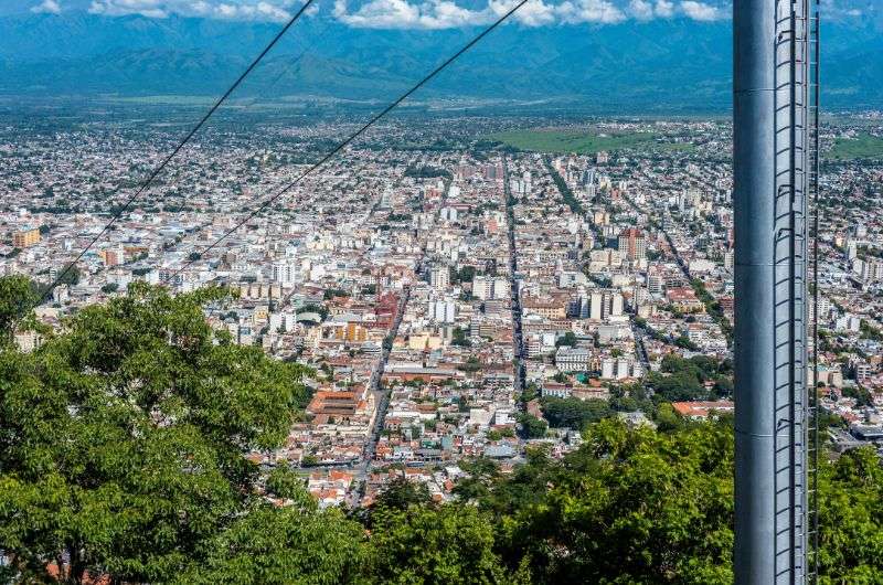
The last place I recommend reminds me a bit of Barcelona. It's the San Bernardo hill (Cerro San Bernardo), offering a marvelous view of the entire city. The summit of San Bernardo is at 1,472 m (4,829 ft), and you can reach it either by foot or by cable car. If you choose to go on foot, you have two options: a path with 1,021 steps or a 2 km (1.24 mi) uphill route. Be prepared for the heat; you'll be grateful for any moment spent out of the sun. Naturally, we opted for the simplest option, the cable car. The ride is slow, taking about 10 minutes, but I'm not complaining; it's still better than walking.
At the top of San Bernardo, a stunning city view awaits you. For the romantics, I recommend heading there for sunrise. On the opposite side of the viewpoint, you can stroll through a park with artificial waterfalls and lots of trees and flowers. The park is okay, but it's definitely not the reason to come here.
Restaurant tip: I give you plenty of tips, but write this one down asap because finding a good restaurant in Argentina is quite a feat. La Salteñeria Empanadas is a place where they make the best empanadas I've ever eaten. Plus, the food comes super fast, there's a nice garden, and the service is decent. The small menu, with only about 6 dishes, is ideal—I left stuffed to the brim, and the bill for both of us was ARS 1,200 (USD 12).
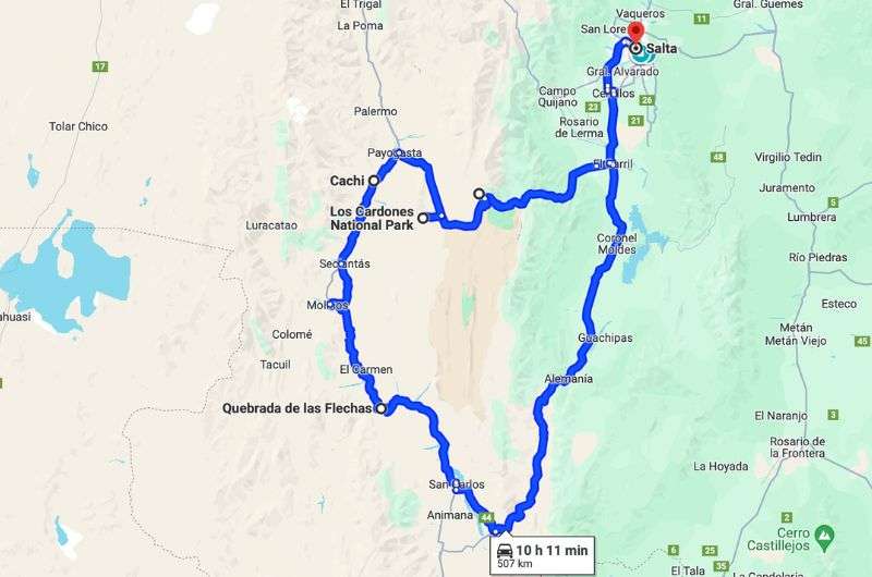
Discovering the natural beuties of Salta&Jujuy (see this map on Google Maps)
Main sites visited on day 2: Cuesta del Obispo (Bishops hill), Los Cardones National Park, Cachi, Canyon of the arrows (Quebradas de las Flechas)
Restaurant tips: La Salteñeria Empanadas | Restaurante ABASTO CACHI
Hotel recommendations: MG Design Hotel Boutique
Further reading: 11 Amazing Things to Do and See in Jujuy and Salta | The Big 3 of Altitude Sickness: AMS, HAPE, HACE
The first day was a laid-back city exploration, everything within walking distance, allowing you to leave your car parked at the hotel all day. I hope you enjoyed it because today is the complete opposite. Brace yourself (and especially your back) for some serious driving. I recommend setting off really early to fit everything in.
And make sure you start with a full tank. Seriously. The first gas station isn't until Cafayata, meaning it's 330 km (205 mi) from Salta. And believe me, the last thing you want is to be stranded in the middle of nowhere under the blazing sun.
An enjoyable road trip full of epic views
Distance from previous stop: 100 km (60 mi), 2 h 10-minute drive
Time spent here: 30 min (driving)
The first stop isn't exactly a stop but more of a drive-through. Cuesta del Obispo is a scenic road that climbs to an elevation of 3,348 m (10,984 ft), offering stunning views of the surroundings. The road stretches about 20 km (12.4 mi), and you'll ascend 1,200 m (3,940 ft), so expect your ears to pop. The route reminds me of a mix between the USA and South Africa, with its massive cacti, dramatic cliffs, and gorgeous rock formations.
Fun fact: The road is named after Bishop Julián Cortazar, who was the first to travel it when there wasn't a perfect asphalt road there yet, so I don't envy him one bit. After the challenging climb, you'll be rewarded with views of the Valle de Lerma and Valles Calchaquíes.
Tip: It's not so much a tip as a warning: Altitude sickness can start at elevations above 3,000 m (9,800 ft). So be prepared that you might not feel your best. I personally struggle with it, feeling nauseous and headachy—classic symptoms. But my girlfriend is always totally fine, as if it's no big deal. I'd advise reading up on altitude sickness beforehand.
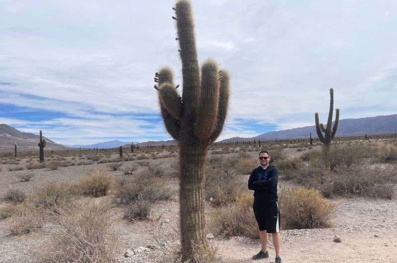
This cactus has an opinion. I like that.
Distance from previous stop: 23 km (14 mi) 30-minute drive
Time spent here: 1–5 hours depending on which hike you choose
Los Cardones National Park spans 650 km² (250 mi²), offering everything from mountains and valleys to gorges and cacti (well, not everything, but you get the idea). The park's elevation ranges from 2,700 to 5,070 m (8,860 to 16,630 ft). Good news for you (and us) is that you can comfortably drive into the park.
Travel along National Route 68 and then National Route 33—it's a stunning scenic drive. If you've ever driven through the national parks in the western U.S., you'll get the same vibes here. Picture this: an endless, wide road stretching ahead with the beauties of Los Cardones National Park all around.
What's Los Cardones National Park like? Imagine a barren landscape where the largest "greens" are cacti, abundantly dotting the area. The park is named after the Cardon Grande cactus. And yes, they really do prick—my girlfriend didn't believe it and had to learn the hard way.
The park offers several marked trails starting at various points, lasting from tens of minutes to several hours. So, your time in the park depends on the trail you pick (surprisingly).
We were in the mood for a good walk, so we chose the longest trail—Valle Encantado (Enchanted Valley). It took us about 3 hours, and I highly recommend it. "Hike" might be a bit of an overstatement; I'd call it a leisurely walk with stunning views. For instance, you'll see the beautiful colored Cerro Tintin Mountain, showcasing sediment layers that beautifully complement the already picturesque desert. We were the only ones on the trail, not counting the over 100 bird species present.
I have another Los Cardones NP hike to recommend—the Mirador Sendero. Don't worry, it's not hours long. Mirador Sendero is a brief 130 m (420 ft) hike, but the view is absolutely breathtaking, offering vistas of Cachi (a desert town I'll talk about later) and the surrounding colorful mountains.
Tip: There are no restaurants or toilets in the park. It's just you, your car, and the cacti. But don't fret, the next stop is Cachi, where you can dine at Restaurante ABASTO CACHI. The food is good, the outdoor seating is nice, though the chairs are extremely uncomfortable. Still, I recommend it because you won't find many other options in Cachi.
You really don’t need to go there, to be honest...
Distance from previous stop: 41 km (26 mi) 40-minute drive
Time spent here: 1–2 hours (including lunch)
Hmm, Cachi... if you're pressed for time, I'd advise skipping Cachi altogether. It's just a small town in the desert, nothing that special. But to give credit where it's due, there's a charming colonial-style square—Plaza 9 de Julio. Besides that, you'll find the San José Church and an archaeological museum. But personally, the view of the town from the Mirador Sendero hike would be sufficient.
It's a bit like going for a ride on Mars
Distance from Salta: 92 km (57 mi) 2 h 30-minute drive
Time spent here: 1 hour
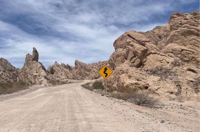
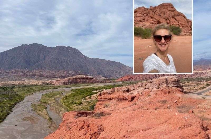
The rock formations of Quebradas de las Flechas are definitely worth the additional 2.5-hour drive. Stretching around 30 km (19 mi), the road starts near the town of Angasaco and extends to San Carlos (roughly, as it doesn't have a precise start and end). It's massive and utterly divine. The landscape makes you feel like you're on another planet—I've seen nothing like it elsewhere.
Expect it to be more of a car hike, though. It feels about 200 °C (392 °F) outside, and believe me, you won't want to wander around in that. You'll be driving on National Route 40. And while I mentioned the road in Los Cardones National Park is in great shape, this one isn't. Don't expect asphalt; it's a gravel road, and be prepared for some terribly bumpy and dusty stretches. The good part is you can stop wherever you like and explore the surroundings. Since you'll be moving at about 30 km/h (19 mi/h), there's plenty of time to enjoy the views.
The route is lined with sharp, tilted rock formations that seem like they might break off and fall on your car at any moment. They almost look like they're bowing to the wind. Reaching up to 20 m (66 ft) high, yeah, it's a bit scary. The whole formation dates back to the Precambrian era when tectonic movements raised the granite rocks. In some places, these uplifts tilted the sedimentary layers towards the sky. Erosion over time sculpted these formations into their current shape, reminiscent of arrow tips, hence the name Canyon of the Arrows.
Driving and discovering another natural beuties of Salta&Jujuy (see this route on Google Maps)
Main sites visited on day 3: Shells' Ravine (Quebrada de las Conchas), Cafayate wineries
Restaurant tips: La Salteñeria Empanadas | Como en Casa
Hotel recommendations: MG Design Hotel Boutique
Further reading: 11 Amazing Things to Do and See in Jujuy and Salta
On your third day on your Jujuy & Salta trip, you'll be heading south from Salta again, and it's going to be a mix of car tourism and actual trekking.
Quebrada de las Conchas is the top thing to see in Salta and Jujuy!
Distance from Salta: 177 km (110 mi), 2 h 40-minute drive
Time spent here: 2 hours
Shells' Ravine (Quebrada de las Conchas) is an absolute gem and, for me, the must-see in the Salta and Jujuy area. It's like Monument Valley in the US, but bigger. The ravine stretches over 50 km (31 mi) along Highway 68, and I promise, this drive will be a treat. There are numerous spots along the way where you can pull over for some stunning views (and killer photos, of course).
One such spot is El Sapo, which translates to 'the toad.' And just off the road, there's a rock formation that remarkably resembles a toad. Guess who sculpted it? Nature itself. Another stop further from the road is La Yesera. You'll park your car and walk about 30 minutes to reach it, where you can marvel at the brilliant layering of the rocks and the vibrant colored mountains. Don't miss Las Ventanas, another must-stop, where the rock formations feature natural “windows”. For this one, you just pull over, as there's no need to trek to get a closer look.
As I mentioned, there are plenty of interesting stops along the way. You could even venture off the main road, but since Shell's Ravine isn't our only destination for the day, sticking to the main route should suffice.
Personally, I found there are relatively few hikes here—it's more about stepping out of the car to soak in the views. And boy, is this place photogenic! At times, I felt like it must have been crafted by AI, haha. The epic red rock formations give you this otherworldly vibe, almost like you're on Mars. Some formations, due to their shapes, have earned specific nicknames, like El Amphitheatre (The Amphitheater), La Garganta del Diablo (Devil's Throat), and Los Castillos (The Castiles).
The entire valley was carved out by erosion millions of years ago. It got its name from the marine fossils found here, remnants from when the area was an ocean floor some 15 million years ago.
You need to try the authentic Argentine wine!
Distance from previous stop: 20 km (12 mi), 20-minute drive
Time spent here: 2–4 hours
Feeling peckish? At this point in the itinerary, I’d say there’s a good chance of a tummy rumble. In that case, I recommend the Como En Casa restaurant in Cafayate. The interior might not blow you away, but the food is genuinely good. They serve excellent homemade pasta. It's a renowned spot in the area, so be prepared to wait a bit.
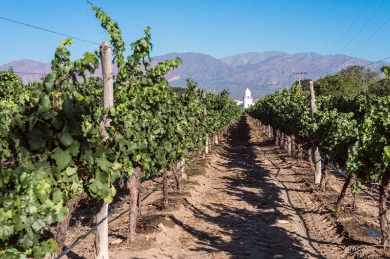
Cafayate is one of Argentina's significant wine regions, definitely worth a visit. Besides wine, you'll find mountains to gaze at while holding a glass of wine. The area is known for its dry climate, cooler nights, and warmer days. Combined with the relatively high altitude (1,700 m (5,600 ft)), it's the perfect place for wine cultivation. Torrontés is the signature grape variety of this region.
There are plenty of vineyards here, each with its own visitor policy. Some don't require reservations—you just show up, and they greet you with a smile and a pour. Others need you to book tastings in advance. At some places, you don't need to reserve for tastings but for vineyard tours instead. Occasionally, local winemakers might even offer you a taste of their labor for free, something I haven't encountered elsewhere. Winemakers worldwide, take note.
Besides the vineyards, you'll find, what else, a wine museum, and The Cathedral of Our Lady of Rosary, located in the city center. But let's be honest, the main reason you're heading to Cafayate is to savor the fantastic wines and perhaps take a bottle or two home with you.
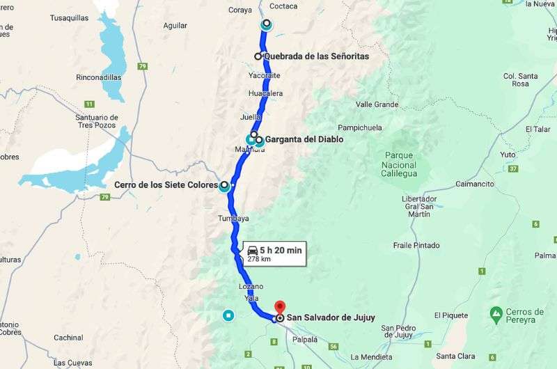
Map of our one-day itinerary in Quebrada de Humahuaca. See this route on Google Maps
Main sites visited on day 4: Cerro de los Siete Colores (The Hill of Seven Colors), Pucará de Tilcara, Garganta del Diablo, Quebradas de las Señoritas, La cercanía de los 14 Colores del Hornocal
Restaurant tips: Restaurant Flor Del Pago | GAIA | PUERTO YALA - Cocina + Bioconstrucción
Hotel recommendations: Hotel Altos de la Viña
Further reading: How to Visit Quebrada de Humahuaca? 9 FAQs and Pro Tips | 11 Amazing Things to Do and See in Jujuy and Salta | Iguazu Falls 3-Day Itinerary + FAQs for Planning Your Trip
After three nights in Salta, it's time to head a bit north to San Salvador de Jujuy. It's about 93 km (58 mi) from Salta, so you'll get there in no time by car.
We stayed at Hotel Altos de la Viña. The hotel boasts fantastic staff, great breakfast, and everything is spotlessly clean. Plus, you get both an indoor and outdoor pool, a real treat in Argentina. The facilities, well, let's just say they aren't the most up-to-date, but overall, it's a good choice.
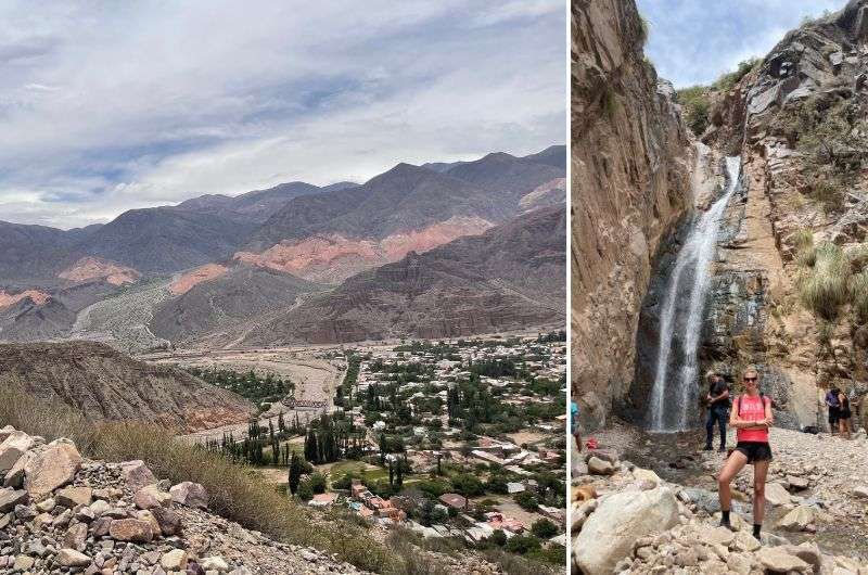
San Salvador de Jujuy is an excellent base for visiting Quebrada de Humahuaca—a mountain valley stretching about 155 km (96 mi) from north to south along National Route 9. The valley is famed for its colorful rock formations along the mountain sides, and trust me, it's a sight to behold. Plus, it's home to many indigenous people who have lived there for thousands of years.
And I've got a fantastic restaurant tip for you—Restaurant Flor Del Pago—one of the best places I've visited on my travels. The service is excellent, quick, and unobtrusive. The food, especially the ceviche, is top-notch. There's ample parking out front and a lovely garden.
I allocated one day in the itinerary for Quebrada de Humahuaca, but if you want to explore all the interesting spots and natural beauty the area offers, I'd recommend setting aside at least two days.
Tip: Check out my article "How to Visit Quebrada de Humahuaca? 9 FAQs and Pro Tips" to see all the places we visited.
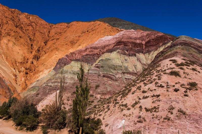
Cerro de los Siete Colores
Distance from San Salvador de Jujuy: 66 km (41 mi), 1-hour drive
Time spent here: 10 minutes
The first stop is a quick one where you don't even need to pull over. You'll drive past the Hill of Seven Colors, which, as the name suggests, displays seven different colors. This hill was formed by the gradual sedimentation of variously colored layers. It's truly unbelievable what Mother Nature can create. And just wait until you see the 14 color mountains, also known as the Rainbow Mountain—it's a spectacle with an extra seven colors!
A little tip: I recommend heading out early in the morning. Not just to make sure you have enough time for everything, but also because the colors are more vivid in the low morning sunlight, making the experience even more magical.
Pucará de Tilcara—preserved Inca fortress
Distance from previous stop: 26 km (16 mi), 30-minute drive
Time spent here: 0.5–1 hour
The town of Tilcara is one of the most visited in the Quebrada de Humahuaca area. The main attraction here is Pucará de Tilcara—a pretty well-preserved Inca fortress. This fortress once served as the province's capital and was built around the 12th century. It was strategically placed on a hill, offering a splendid view of the surroundings.
If I set aside Peru, Pucara de Tilcara seems to be the largest Inca fortress I've ever seen. At its peak, it covered an area of 61,000 m2 (656,600 ft2) and housed 2,000 residents. There are many informative signs within the fortress area where you'll learn quite a bit about the fortress itself, though not so much about Inca culture.
Interesting fact: The fortress was listed as a UNESCO World Heritage site in 2012. Whether it deserves that status, I'll let you decide.
One more note: Tilcara is essentially your only option for grabbing a bite and refueling on today's journey, so make sure to take advantage of it.
Make sure you rent a good car that can withstand the Devil's Throat
Distance from previous stop: 6 km (3.7 mi), 30-minute drive
Time spent here: 30 min
If you've been wondering why I recommended renting a high-performance car, you'll get it on this journey—it's a proper offroad experience. Once you reach the parking area, you'll know you've made it. Pay the entrance fee, register, get briefed on the route, and off you go.
From the parking spot, it's about 600 m (1,970 ft) on foot to the waterfall. The path is slightly uphill but nothing too dramatic. The waterfall, well... it's nice, but I wouldn't exactly call it a waterfall; it's more like a stream. In general, the individual spots in northwest Argentina may not be super wow-inducing, but the overall scenery is epic, and even a visit to a place like this stream can be an experience.
Tip: Speaking of waterfalls, if you want to see some seriously massive ones, you've got to visit Iguazu Falls, located on the Argentina-Brazil border.
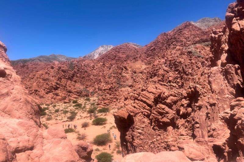
Quebradas de las Señoritas isn’t for señoritas!
Distance from previous stop: 40 km (25 mi), 1-hour drive
Time spent here: 2 hour
Quebradas de las Señoritas is a huge desert area with red rocks, sitting at an altitude of 2,900 m (9,500 ft), so those that tend to suffer from acute mountain sickness, you're in the clear here.
You can drive right up to the start of Quebradas de las Señoritas. Continue until you hit the staffed parking area, park your vehicle, and head to the entrance gate. If you're keen on hiking, you'll need to pay for a guide; they won't let you go without one.
There are two hikes to choose from: a 3-hour one and a 1.5-hour one. We opted for the shorter one at ARS 3200 (USD 4). The guided tours usually form groups of around six people.
It's typically hot here most of the year, so like us, you'll probably appreciate the option of a shorter trek. It's still absolutely beautiful and worth it. If you want to communicate at least a bit with the guide, better download an offline dictionary, as the signal isn't great everywhere. Luckily, I know a bit of Spanish, so we managed to communicate somewhat, but don't expect to get by with English here.
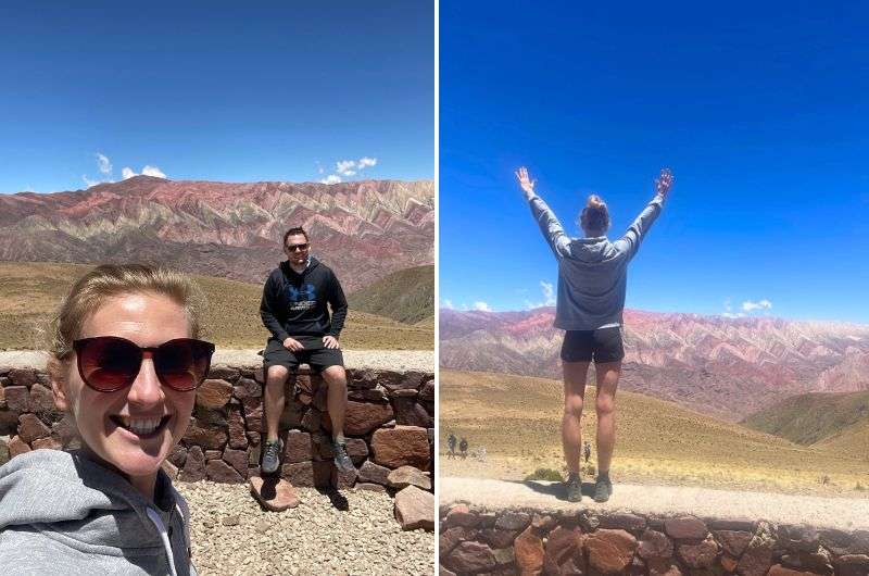
Except for the altitude sickness, the view of Los 14 Colores del Hornocal was perfect!
Distance from previous stop: 13 km (8 mi), 20-minute drive
Time spent here: 2 hours
The 14-Color Mountains are located near the small town of Humahuaca, home to about 11,300 people. This town isn't exactly a knockout, but there are a few sights to see, and a big plus, unlike some other places in this area, is that the people here are really friendly.
What can you see here? Besides loads of tourists, you might catch the oldest building in the region, a church, and the Cabildo, close to the town square. From the square, you can climb up to the Independence Monument.
The journey to the viewpoint of the 14 color mountains is along a rocky road (but compared to the path to the Garganta del Diablo waterfalls, it's a breeze) and will take you about 45 minutes to an hour.
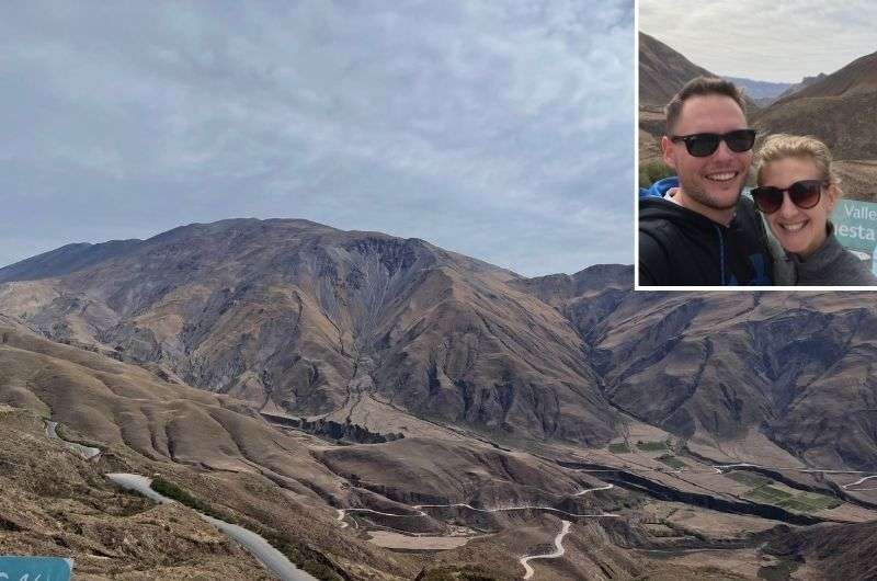
Along the way, you'll climb to an altitude of 4,350 m (14,272 ft), where you'll get a stunning view of this remarkable colorful mountain. It reminds me of Rainbow Mountain in Peru but is much bigger. However, that altitude... it was a bit of a problem for me.
At the viewpoint, there's no wind, and apart from other cars and tourists, nothing will disturb you. If you'd like to walk around and challenge yourself at this altitude, there are several hiking options. The trails are beautiful, and most are up to 1 km (0.62 mi) long. I definitely recommend choosing one in advance, as not every kilometer is created equal. On some trails, you might walk a kilometer while also climbing over 700 m (2,300 ft) in elevation—an absolute killer.
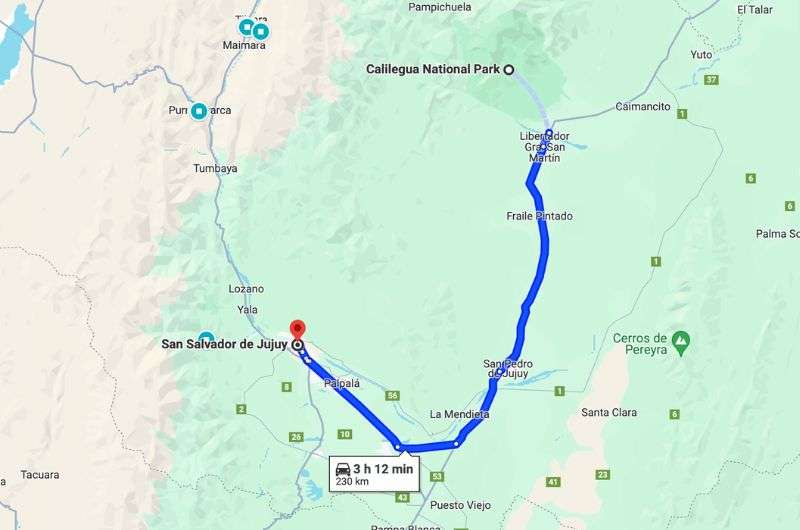
Map of the road from San Salvador de Jujuy to Calilegua National Park. See this route on Google Maps
Main sites visited on day 4: Calilegua National Park (Sendero Bosque del Cielo, Sendero La Lagunita), San Lorenzo
Restaurant tips: Restaurant Flor Del Pago | GAIA | PUERTO YALA - Cocina + Bioconstrucción
Hotel recommendations: Hotel Altos de la Viña
Further reading: Calilegua National Park Guide—How to Visit and FAQs | 11 Amazing Things to Do and See in Jujuy and Salta |
Distance from San Salvador de Jujuy: 115 km (71 mi), 1 h 30-minute drive
Time spent here: 5 hours
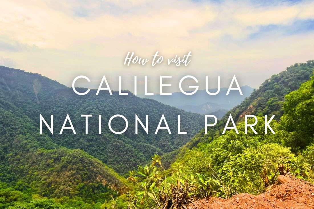
Today, you're off to explore the jungle. Well, it's actually a national park that looks like a real jungle and even has a tropical climate to match. Plus, there are plenty of hikes here, which I think is a nice bonus, especially since the last two days were more about car hiking. And as an added thrill, this place is home to the highest number of jaguars in all of Argentina, so things could get pretty exciting.
Calilegua National Park was established to protect the vast areas of the Yunga. The Yunga is an eco-region in the Andes of South America, known for its high biodiversity and includes a wide range of ecosystems. Thus, Calilengua is a sanctuary for many endangered species of plants and animals, including jaguars, tapirs, and a multitude of bird and reptile species. Yes, you read that right—jaguars, with a population of about 200 here. Worried? Well, let me give you a little spoiler alert: We saw zero animals in the park.
Another important piece of advice: there are pitifully few places to eat along the way, so I recommend having a big breakfast and then heading back to San Salvador de Jujuy for food. You'll come across quite a few gas stations along the way, so that's not an issue.
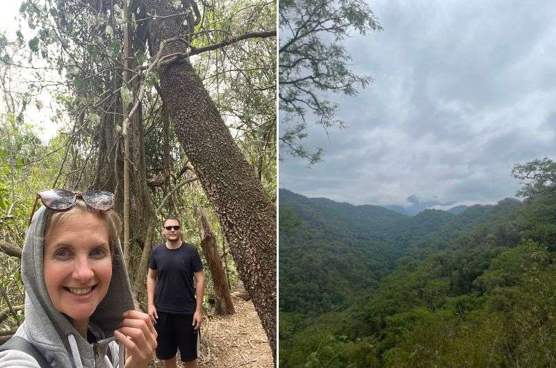
Calielegua National Park isn’t huge, but there are pleasant hikes. And jaguars (that are apparently afraid of people wearing hoodies—hence my girlfriend’s protective outfit)
The entire park is just 23 km (14.3 mi) long and can be driven through in about 45 minutes—the terrain is quite intense with plenty of twists and turns. You'll get to the park via National Route 34, which is pretty smooth sailing, and you'll find your way to the park easily. Only an idiot could miss it from the highway (and that's not you).
Like in other parks in the Salta and Jujuy area, the entrance here is also free. You don't even need a guide to visit the park. However, I do recommend stopping by the information center at the entrance. The folks there are nice and helpful, providing all the information you need about the park and its various hikes.
There are plenty of hikes here. Some are easy and will take about 10 minutes, while others could last up to 3 hours (but you ain’t got that kind of time on this itinerary, sorry!). There's always something to see—the jungle is breathtaking. Plus, there's a sign before each hike indicating the distance, time, and, most importantly, the difficulty level, giving you some guidelines on which hike to choose.
Tip: Want to learn more details about Calilegua National Park? Check out my article: Calilegua National Park Guide—How to Visit and FAQs.
A forest walk to cool off a bit
Hike length: 0.3 km (0.2 mi)
Elevation gain: 11 m (36 ft)
Difficulty level: Easy
Hiking time: 10 min
Trailhead: Google Maps link to trailhead
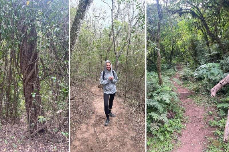
We chose the Sendero Bosque del Cielo hike, located at the very end of the park, while most other trails are closer torhe entrance.
Sendero Bosque del Cielo is a loop of about 1 km (0.6 mi), and unlike the lower hikes, it's quite damp and cool (which I see as a big plus). It's a completely different forest from the one below, reminding me of Monteverde in Costa Rica. And watch out, according to my girlfriend, there are lots of treacherous butterflies that could bite her in the butt, that's how scared she is of them.
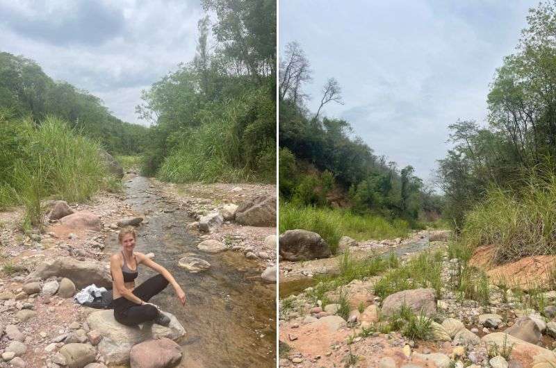
Get ready to get hot @ Sendero La Lagunita
Hike length: 2.5 km (1.55 mi)
Elevation gain: 200 m (660 ft)
Difficulty level: Moderate
Hiking time: 1 hour
Trailhead: Google Maps link to trailhead
This hike will take you about an hour, which might seem like a breeze, but in the tropical climate prevalent here, it's quite the task. The sign may say 2 hours, but you'd have to be moving at a snail's pace.
Over a distance of 2.5 km (1.6 mi), you'll climb an elevation of 200 m (660 ft). At the end, you'll reach a small river, but think of it more as a safari where you might (or might not) see fascinating animals; snakes, spiders, and especially birds. There are really a lot of birds here, and they're intriguing, but come on, who wants to see birds when they could spot a jaguar?
Tip: I've written a separate article on Calilegua National Park where you'll find more hikes, and particularly a useful tip from my girlfriend on how to fend off a jaguar attack.
Distance from previous stop: 16 km (10 mi), 20-minute drive
Time spent here: all day (8 am–7 pm)
I recommend pairing your visit to Calilegua National Park with a trip to San Lorenzo because the mountains here are just wow and among the best I've ever seen. Mountains up to 3,700 m (12,100 ft) high, draped with jungle—you won't find this anywhere else.
And if you thought two hikes were too few, here you'll find another 3 nice hikes that are about 20 minutes each, nothing too extreme. If I had to choose one, for me, the top pick is Fuente del Jaguar (not just for me, it's simply the main hike in San Lorenzo).
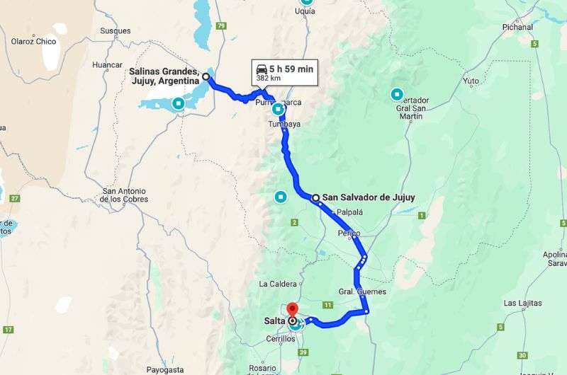
Map of the road from San Salvador de Jujuy to Salinas Grandes and back to Salta. See this map on Google Maps
Main sites visited on day 4: Salinas Grandes
Restaurant tips: Restaurant Flor Del Pago | GAIA | PUERTO YALA - Cocina + Bioconstrucción
Hotel recommendations: Hotel Altos de la Viña
Further reading: 11 Amazing Things to Do and See in Jujuy and Salta | How to Visit Salinas Grandes in 2024: Top 15 Questions Answered
Distance from previous San Salvador se Jujuy: 130 km (80 mi), 2-hour drive
Time spent here: 1–3 hours
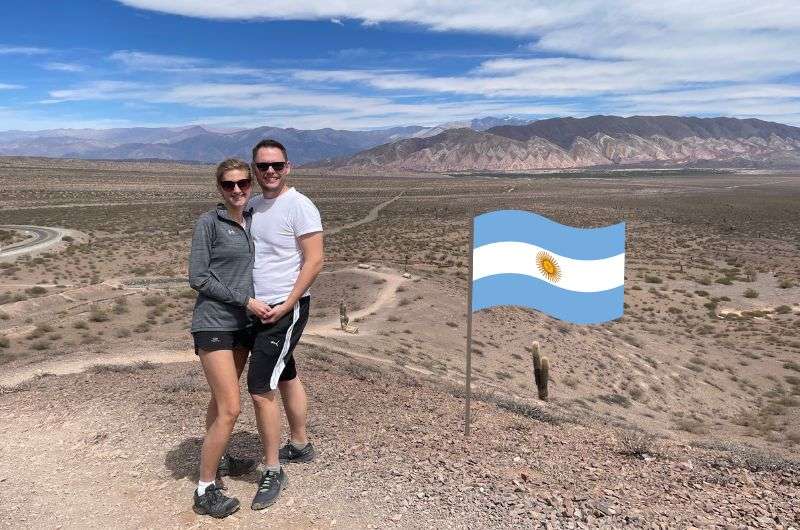
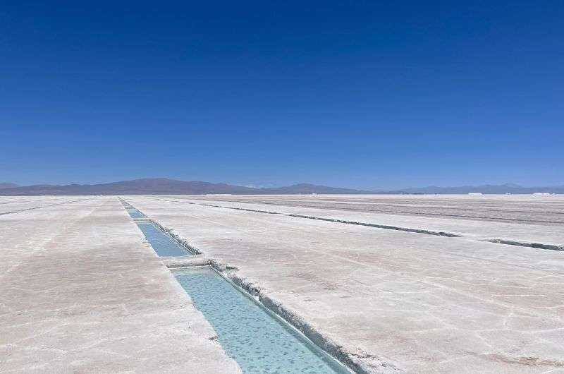
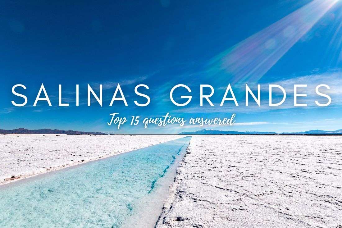
Salinas Grandes are the most famous salt flats in Argentina, covering roughly 6,000 km2 (1,236 mi2)—quite vast, huh? But the largest in terms of area is still Salar de Uyuni, with its 10,582 km2 (4,088 mi2). Like many other places in Salta and Jujuy, Salinas Grandes is situated at an altitude of 3,450 m (11,320 ft) above sea level, so you might feel the symptoms of altitude sickness here, so be prepared.
Salinas Grandes
Visiting this place is definitely an experience to remember. I dare say, I've traveled quite a bit (as you, my loyal followers, surely know), but the Salinas Grandes salt flats impressed me. You'll feel like you've stepped into another world, where a white salt crust stretches all around you.
It's fascinating that there's water under that salt, so theoretically, you could fall through the salt crust into the hyper-saline water beneath. It's so salty that if you dip your hand in the water, it feels like it's in oil. Another interesting fact is that locals mine salt here, creating small salt pools that you can explore. The salt here crystallizes directly from the water, just like in the Dead Sea—a very intriguing process.
Another point of interest is the Ojos de Salar, a natural spring that emerges at Salinas Grandes and has created a transparent, deep salt lake on the surface. If you decide to dip your feet or hands in the lakes, expect them to turn snow-white from the salt. And whatever you do, don't touch your eyes afterward (and don't ask me how I know this)...
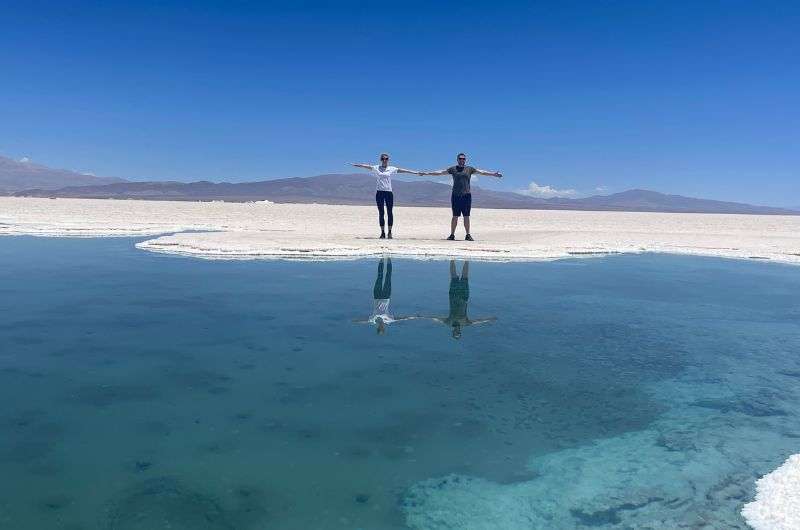
Ojos de Salar
Good to know: You can't enter without a guide, but finding one is easy. We didn't arrange one in advance; we just showed up and negotiated directly. There are plenty of guides available, so it was a breeze. The cost is ARS 5,000 (USD 6) per car, and the setup is that you drive your car while the guide leads on a motorcycle.
The best 2-week itinerary for Argentina
Patagonia Travel Guide: 7 Days of Exploring El Chaltén and El Calafate
How to plan a trip to Iguazu Falls (3-day plan)
12 epic day hikes in Argentina of all difficulty levels
27 fun facts and travel tips for Argentina
This post contains affiliate links. I earn a small commission if you make bookings through my links, at no additional cost to you. Thank you for your support!
Overview of your 6-day Salta&Jujuy itinerary + map
Day 0 of Salta and Jujuy itinerary: Arrival
Day 1 of Salta and Jujuy itinerary: Exploring the Salta
Day 2 of Salta and Jujuy itinerary: Car hiking
Day 3 of Salta and Jujuy itinerary: Best views and taste of wine
Day 4 of Salta and Jujuy itinerary: In the footsteps of Incan culture in the Quebrada de Humahuaca
Day 5 of Salta and Jujuy itinerary: Calilegua National Park and jaguars


Hi, I’m Jan. I travel fast and intensely, whether I’m exploring the buzz of Tokyo in 3 days or road-tripping through mountains and beaches on a 3-week Thailand adventure. And no matter where I am, you’ll always find me in a comfortable hotel at night and eating the best food.
If that sounds like your kind of journey, hop on board, and let’s explore the world together!
I started this blog after realizing how tough it can be to find reliable, authentic travel info. You wouldn’t believe how many “travel bloggers” never even visit the places they write about! On Next Level of Travel, you can count on my full honesty and insights drawn from my firsthand experiences.
Here’s the deal: not every destination is all superlatives and unicorns. I’ll let you know if a tourist attraction isn’t worth your time, like skipping overrated stops in my 2-week Spain itinerary. And when I find something truly special—like the perfect mix of culture and nature in Cape Town—you can trust that it’s worth adding to your itinerary.
Comments | Thoughts? Give us a shout!