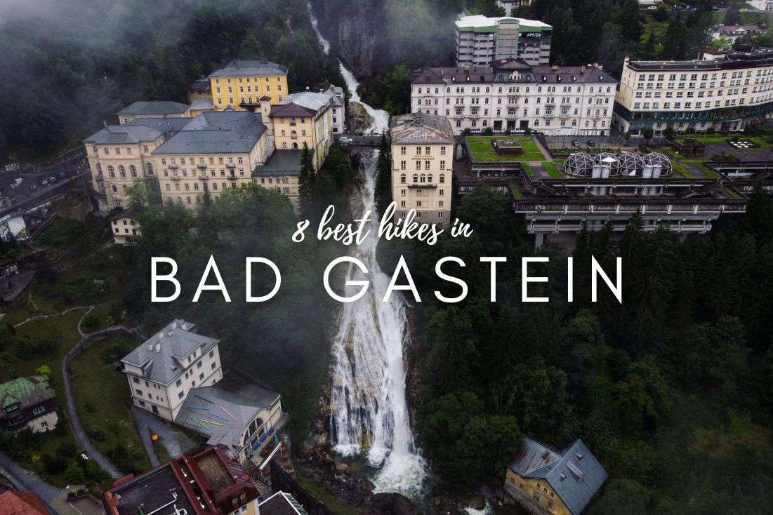

Best hiking trails in Bad Gastein
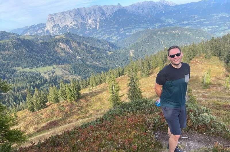
1. Graukogel hike: The customizable winner
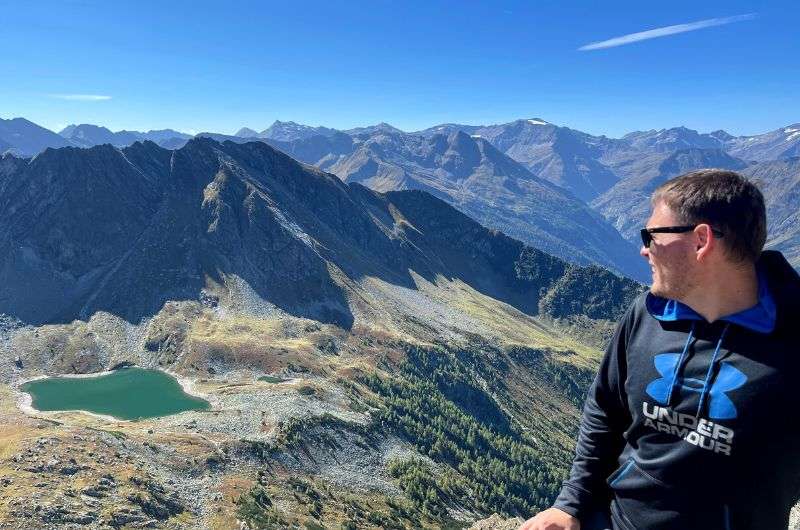
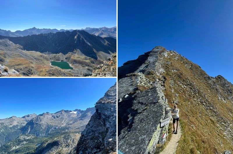
2. Grossglockner hike and Grossglockner drive: A double whammy that should’ve been in 1st place
3. Hike to Stubnerkogel: A challenge worth every step
4. The Sigmund Thun Klamm Waterfall hike: A seasonal must-see
5. Prossau Valley hike: The one with the rock wall
6. Vorderschneeberg Hike: More than just a trek
7. Lichtenstein Klamm hike: A gorge that’ll leave you awestruck
8. Bockhart trail: A Hike with pleasant surprises
Austria is like a paradise for hikers. If you think Bad Gastein is just for old spa-goers and the après-ski crowd, think again. This place is a hidden gem for hiking, with everything from easy valley walks to lung-busting alpine treks with glacier views. And I’ve personally tested them all, just for you (ok, maybe for my own pleasure, too).
In this guide, I’ll walk you through 8 of the best hikes in Bad Gastein, from the panoramic Graukogel trail and slightly-out-of-the-way but stunning Grossglockner hike to a wonderful waterfall loop in Sigmund Thun Gorge and the pristine Prossau Valley, where I could’ve sworn I heard a bear!
Expect detailed maps, my brutally honest trail reviews, and tips on where to park and where to refuel (and where to pack a lunch instead). You'll find a plethora of hotels, apartments, and restaurants in the town, making it the perfect base camp for hiking in the wider Bad Gastein area.
Here’s a list of my favorite day hikes in Bad Gastein:
Let’s get straight to the details of each hike:
Bad Gastein is a natural spa destination
This view stole my heart...
Hike length: 11.4 km (7.1 mi) out-and-back (If you decide to take the cable car, you have two options. The first will shorten your route by 1.7 km (1.05 mi), and the second one by 2.8 km (1.7 mi).)
Elevation gain: 1,117 m (3,665 ft)
Difficulty level: Moderate
Hiking time: 5–6 hours (Using the first cable car will save you 50 minutes, and the second one will cut your time by approximately 1 hour and 30 minutes.)
Trailhead: Google Maps link to trailhead
One of my favorite hikes in all of Austria, the Graukogel hike is amazing!
On this hike to the summit of Graukogel, standing at 2,492 m (8,176 ft), you have two options. Choosing the challenging way means that you will do the entire journey on foot. And I will tell you it will be quite a challenge (I tested it for you), demanding your full effort.
On the other hand, even if you use the cable car both up and down, it's still quite a hike. From the cable car to the summit, it's approximately 1.5 km (0.9 mi) with a significant ascent. Please don’t make the mistake of taking your frail granny on the hike, thinking it’ll be a piece of cake.
Even if you take the cable car, this hike will give you a hard time. I advise walking the whole way only for determined and experienced hikers
We set off (and that was our fateful mistake) from Bad Gastein (check out the article about the 7 Top Tourist Cities in Austria to see my opinion on Bad Gastein). We left early in the morning, so we spent the previous night at the Johannesbad Hotel Palace.
More about the hotel: For me, Johannesbad Hotel Palace is a great hotel with a delicious breakfast and a nice (but small) spa. We haven’t been there during the peak ski season, but I cannot imagine myself trying to squeeze into the spa with tons of other semi-naked people.
Now, here's a valuable tip: I recommend taking the Graukogel lift up and then starting the ascent on foot from 1,950 m (6,398 ft). It's much better because once you get off the cable car, the path practically turns into stairs, which is much easier on your knees than traversing through the mud in the forest (where you won't see anything interesting anyway).
As you might suspect, I tried walking from Bad Gastein, so I’m able to advise you definitely NOT to.
My knees still hate me..but the endorphins and the final view made up for it
Additionally, you will save roughly 950 m (3,117 ft) of elevation gain if you take the cable car. This gives you enough energy savings for a real trip through some of the most breathtaking scenery I've seen in the Alps, including views of the Grossglockner trail and other breathtaking mountain peaks.
The majority of aspiring trailblazers and bloggers claim that the hike takes three hours in total, and guess what? They’re not wrong.
Don't expect any extra-groomed paths on this hike. The trail goes through the forest, over rocks, and in some places (especially just below the summit), it's truly steep. Adding the remnants of snow that you might encounter, this hike requires caution, physical fitness, and good footwear.
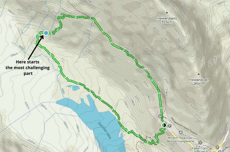
There are amazing views from the summit. The very hazardous final 300 m (984 ft) along the cliffs is the only drawback. Why Austria hasn't yet secured that section is beyond me. The fact that you have to descend the same way back is something else about which I wasn't too thrilled.
Conversely, you can then return to Gastein via the cable car, resembling a respectable adult (your knees will thank you).
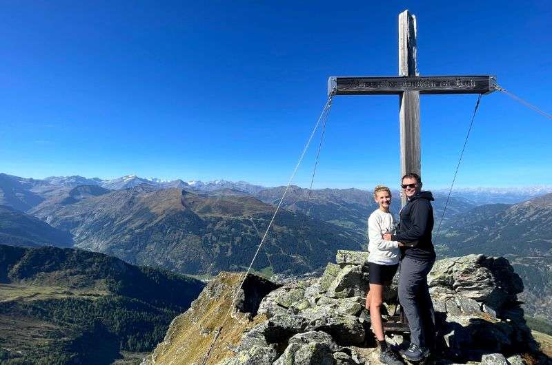
Tip: If this hike isn't challenging enough for you, you can merrily continue for another 45 minutes to the summit of Hüttenkogel at 2,231 m (7,320 ft) from Graukogel.
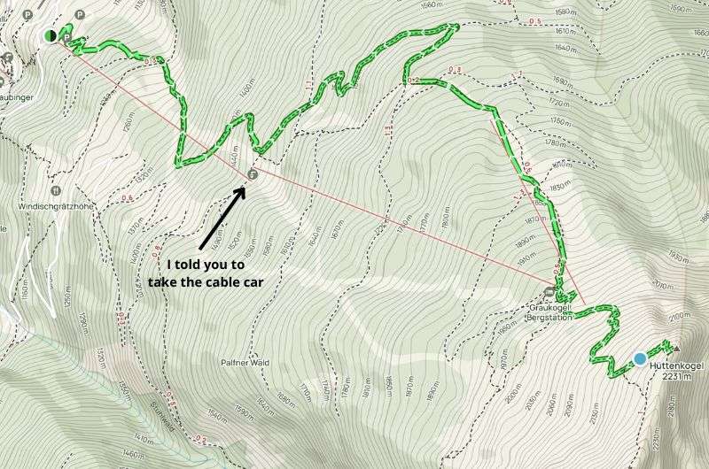
Map of the hike from Bad Gastein to Graukogel. See route details on Alltrails
If you don't heed my recommendation and go the entire way on foot, you'll definitely get hungry during the hike. But from what I've seen and had the chance to try, I recommend not stopping anywhere.
Along the way, you'll come across several average-looking restaurants. I know, don't judge a book by its cover, but we followed that rule once and I'll say just one thing: if you don't want to get into a conflict with an unpleasant waitress, then don't forget to bring cash. But if you hold out until you're back in Bad Gastein, aka one of the best cities in Austria, try the Wirtshaus Windischgrätzhöhe restaurant, which is definitely worth a visit.
Hungry? No problem. Eat blueberries during the hike and wait until you get back to Bad Gastein
On this hike, the best thing for me is the option to tailor it to your needs (and abilities). So, even if you set out on a tour with a lady who claimed in her messages that she's a great athlete and loves mountain hikes, but in reality going up to the third floor using stairs is challenging for her, you don't have to cancel this trip; you'll just end up spending more money on cable car tickets.
These Grossglockner mountains are not far from Bad Gastein
Hike length: 6 km (3.7 mi) loop
Elevation gain: 430 m (1,400 ft)
Difficulty level: Hard
Hiking time: 2.5 hours
Trailhead: Google Maps link to trailhead
This hike could easily snag the top spot on this list of best hiking in Bad Gastein if it weren’t for the fact that it's not exactly in Bad Gastein. So, it gets a few points docked and lands in a still-impressive second place. From Bad Gastein, it's about a 1.5-hour drive to the starting point of the Grossglockner Hike.
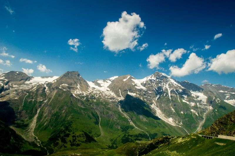
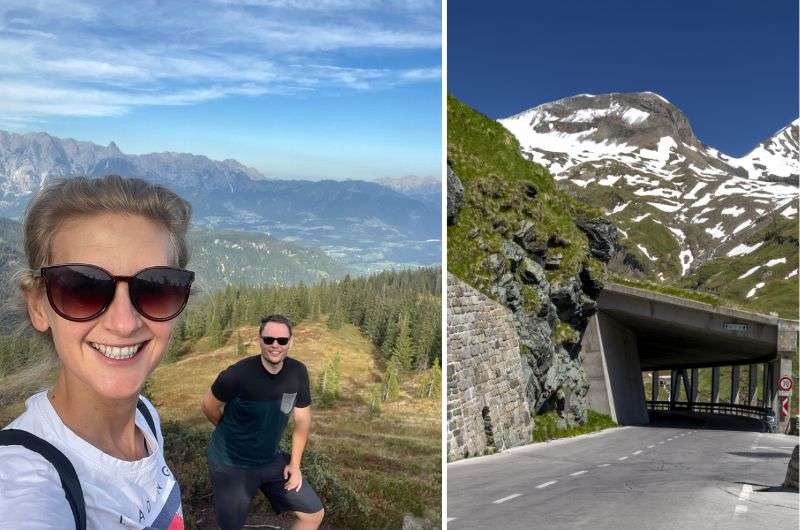
Grossglockner is the highest peak in Austria at 3,798 m (12,461 ft). So, get ready for a proper climb, but also for stunning nature and views. But if you've read my article about the best places to see in Austria, you'll probably know that the Grossglockner High Alpine Road is, for me, the best spot in all of Austria.
There are many trails to choose from, but if you don't want to spend more time selecting a route than on the actual hike, choose the trail based on my recommendation:
Really hard one but really good one (see the map on Alltrails.com)
This hike isn't particularly long, but it's quite challenging. If you're imagining a relaxed walk up a gentle hill, then choose a less demanding route. But if you're a badass like me, then you'll be thrilled.
The trail leads you from Kaiser Franz Joseph Höhe to Pasterze, the largest glacier in the Eastern Alps. And that's something you definitely want to see. Be prepared for steep descents at the beginning and rocks where you sometimes have to use steel cables to cross safely.
Next, follow the straight route to Gamsgrubenweg. It is a challenging mountain path that requires determination or prior mountaineering experience. For nearly the entire duration, one must scramble or climb rocky, steep slopes. But you are going over glaciers, so it should be expected that it won't be the easiest hike.
Epic and challenging: From Kaiser Franz Joseph Höhe to Pasterze Glacier—steep trails, steel cables, and breathtaking Alpine views
If you want to choose an easier way, you can use the Gamsgrubentunnel, 6 tunnels that lead directly from the garages across from the Grossglockner and Gletscher Pasterze. In corridors resembling mine shafts, you can see exhibitions on the themes of water, gold, and mountain crystal, and thanks to sound effects, you can also hear them.
You can park (for free) in what’s probably the most scenic parking garage I’ve ever seen. Next to it is also an information center, which could be useful when you’re deciding on a hiking route (are you seriously doubting my choice? How dare you!).
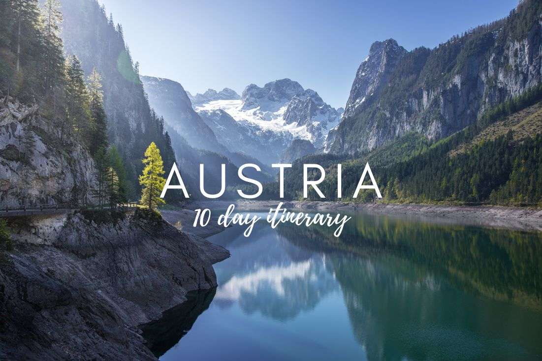
Tip: Want to combine the hike with a visit to other great places in Austria? Then, be sure to get inspired by my meticulously planned 10-day itinerary for Austria.
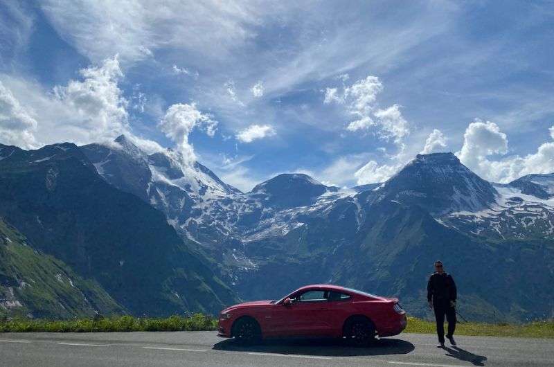
This road with these views is the best thing about this hike! @ Grossglockner Alpine Road
The extremely picturesque Grossglockner High Alpine Road is 48 km (30 mi) long and starts in Bruck an der Grossglocknerstrasse and ends in Heiligenblut, and provides epic view after epic view of the Alps.
Along the route, there are several parking lots with hiking trails that lead to the most well-known lakes and peaks, too.
How much time you wish to spend on the High Alpine Road on the way to the Grossglockner hike is up to you, but I’d give it at least a couple of hours. You could easily spend the entire day here if you choose to pause at each viewpoint and take in the surroundings (just like us).
Good to know: Before you blindly get into your car and head towards the High Alpine Road, check your calendar because this road has opening times! It’s open roughly from late April to early November (depending on the weather and snow conditions).
Are you ready for this?! @ Stubnerkogel
Hike length: 13.8 km (8.6 mi) loop
Elevation gain: 1,140 m (3,740 ft)
Difficulty level: Moderate
Hiking time: 6.5 hours
Trailhead: Google Maps link to trailhead
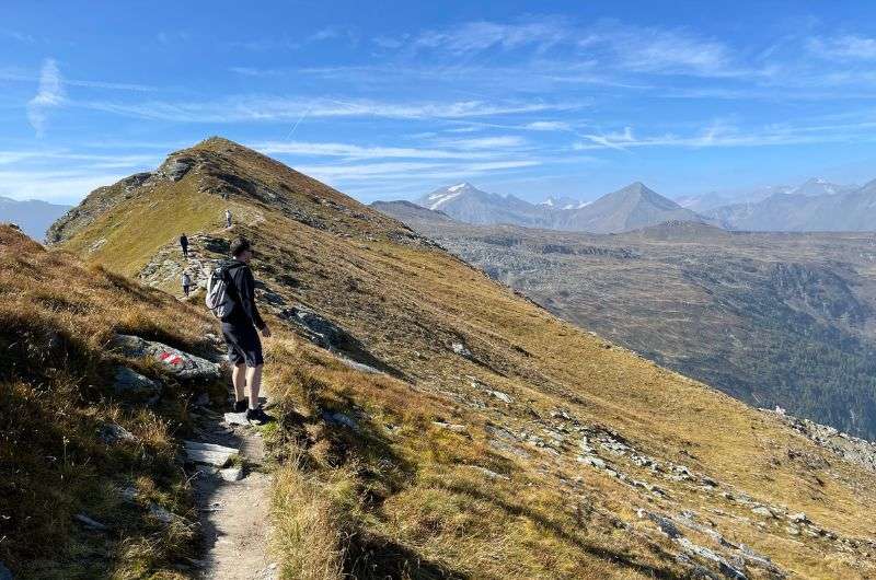
The hike from Bad Gastein to Stubnerkogel is on the tougher side, mainly because of its length. I usually lean toward shorter hikes, but this one is more of a full-day affair. However, the destination is totally worth it.
For those of you put off by the distance, there's a cable car option. You can just ride up and enjoy the best parts without breaking a sweat.
For those who believe the best views are earned, strap on some sturdy hiking boots and make a pit stop at Stubneralm-Hütte. It's an inn with accommodation. Can't vouch for the sleeping arrangements, but the food? Pure Austrian delight.
Stubnerkogel is a tough one!
The Stubnerkogel hike is on the longer side—it takes 6.5 hours... a good thing those views are worth it!
And before you digest your dumplings, you'll reach the majestic Stubnerkogel Mountain, towering at 2,246 meters (7,369 ft) above sea level. The mountain offers breathtaking views of the surrounding Salzburg ranges.
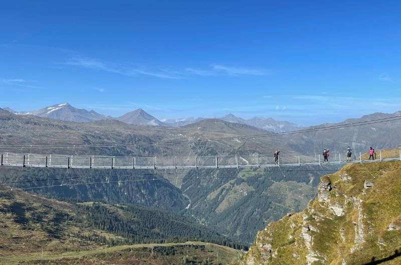
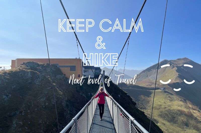
Besides soaking in the panoramas, you can take a stroll across the suspension bridge or step onto the viewing platform. And this brings us to...
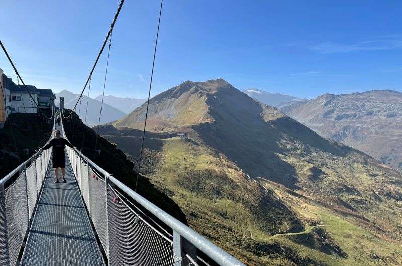
The suspension bridge on Stubnerkogel
The suspension bridge is the best part of the Stubnerkogel hike, hands down. If you take the cable car, you'll see it as soon as you step out. If you're hiking, well, you'll see it when you see it. The bridge sits 28 m (91.9 ft) high and stretches a whole 140 m (459.3 ft).
It's officially open all year, but I'd recommend going only in good weather. Trust me, you don't want to be swaying side to side in the middle of a 28-m-high "walkway" during a crazy windstorm. There’s also an unwritten rule that you walk in one direction only, as the bridge is just 1 m (3 ft) wide. Believe me, leaning over the railing to dodge oncoming people is not an experience you want.
If you make it across the bridge, just a bit further is the Glocknerblick viewing platform. From there, you get a fantastic view of Austria's highest mountain, Großglockner, which you'll recognize instantly if you’ve followed all my advice and already hiked that beast.
The way from Stubnerkogel back to Bad Gastein is not the best in my experience; it's too steep and practically follows the cable car. But you probably already found that out if you decided to walk up as well.
However, once you get up there, you'll find well-maintained gravel paths along the ridges and benches where you can chill and watch the cows for a while.
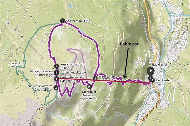
Map of loop Stubnerkogel hike, which is definitely worth a visit. (see full details on komoot)
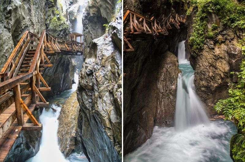
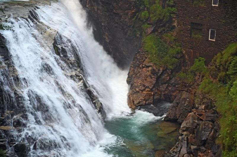
Walk the trail right next to the waterfall!
Hike length: 4.2 km (2.6 mi) loop
Elevation gain: 175 m (574 ft)
Difficulty level: Easy to moderate
Hiking time: 1 hour 30 minutes
Trailhead: Google Maps link to trailhead
No wonder this hike scored a solid fourth place. Unless you're a die-hard fan who reads all my articles, you might have missed that the Sigmund Thun Klamm Waterfall is actually among the top 11 tourist attractions in Austria (as curated by yours truly). That's why I've sneaked it into this list, even though, technically (again), it's not exactly in Bad Gastein.
But trust me, once you read my thoughts and see the photos, I doubt the less-than-an-hour drive from the Johannesbad Hotel Palace will put you off.
This hike is more like a leisurely walk. The Kapruner Ache River chose to show off its strength and chisel its way through the rocks immediately after the town of Kaprun. And it really is impressive, I have to say. A 320 m (1,050 ft) trail with pools and ponds has been carved out by the river through solid rock and stones.
Narrow and slippery wooden walkways and bridges run alongside the river. The entire path is really easy except for the last part, where the path steeply descends, but nothing you can't handle. You’ve been hiking in Bad Gastein, for goodness sake, you’re practically a pro!
A map showing the hiking trail to the Sigmund Thun Klamm Waterfall (thanks, Alltrails.com!)
If you’re planning a trip to the Sigmund Thun Klamm Waterfall and it’s getting close to winter, visit their website first. You might come across a message that clearly states: "Due to the weather conditions, our gorge is already on its winter break. See you next year." And that’s how you know you can’t go to the waterfall.
Despite the fact, that TLC is telling you to “don’t go chasing waterfalls”, my advice is to ignore them and do the complete opposite. Those waterfalls are what make this hike so interesting. When you walk there on those wooden (slippery) stairs, and the waterfalls are really close beside you, it's truly an experience.
If you thought of bathing in the water, I'll disappoint you right away; swimming in the river is prohibited. At least, that's what the signs we encountered along the way claimed. As they say, “What the eye doesn't see, the heart doesn't grieve over”, but I’m on Santa’s nice list, so I didn’t jump in.
Pro tip: If you want to experience more hiking in Austria, check out my article on what to do in Zell am See.
Another hike through amazing Austrian nature
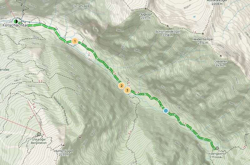
Hike length: 10.6 km (6.59 mi) out-and-back
Elevation gain: 294 m (964.6 ft)
Difficulty level: Moderate
Hiking time: 3 hours
Trailhead: Google Maps link to trailhead
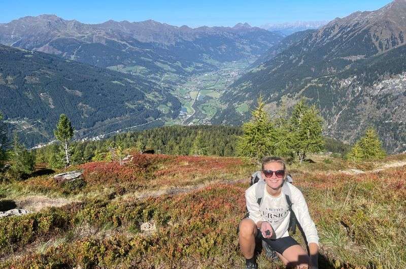
This trail isn't as well-known, so if you set off early in the morning, you'll have it all to yourself. And what more could you wish for than to walk alone in peace and quiet (unless you sing while you hike) through the beautiful Austrian countryside? All around you, you’ll see hills, lush trees, waterfalls, rushing crystal-clear water, and views of snow-capped peaks.
Prosau Valley hike
I expected a very easy hike and got a medium level because there's one challenging section on the trail with an elevation gain of about 300 m (984 ft), and also, an 11 km (6.8 mi) round trip is quite long. If it hadn’t been for the demanding previous day, I'd rate the Prossau Valley hike as a 3-hour leisurely walk in a beautiful high-mountain valley. We were a bit tired already, so it seemed harder than it probably was.
Regarding the hike, the main feature is an amazing rock wall that's about 300 m (984 ft) high, and judging by my well-traveled experience, it's beautiful and worth seeing.
Three three-hour stroll in nature, which reminded me of Yosemite Valley (see the map on Alltrails.com)
For me, the most breathtaking part, where even the staunchest opponents have to pull out their phones and capture the beauty, was the final part of the trail. It was so epic that it reminded me of Yosemite Valley.
Funny story: During our journey, apparently some logging was happening in the forest, so we heard strange sounds. We thought it was a bear, so we really picked up our pace. Then I realized that there are no bears in Austria, but then I remembered that bears are in Italy, and therefore, there could be bears in Austria too, so we sped up even more (something between running and speed walking). Fortunately, we soon realized it was just logging, so we could return to our comfortable pace, pretending that didn’t just happen.
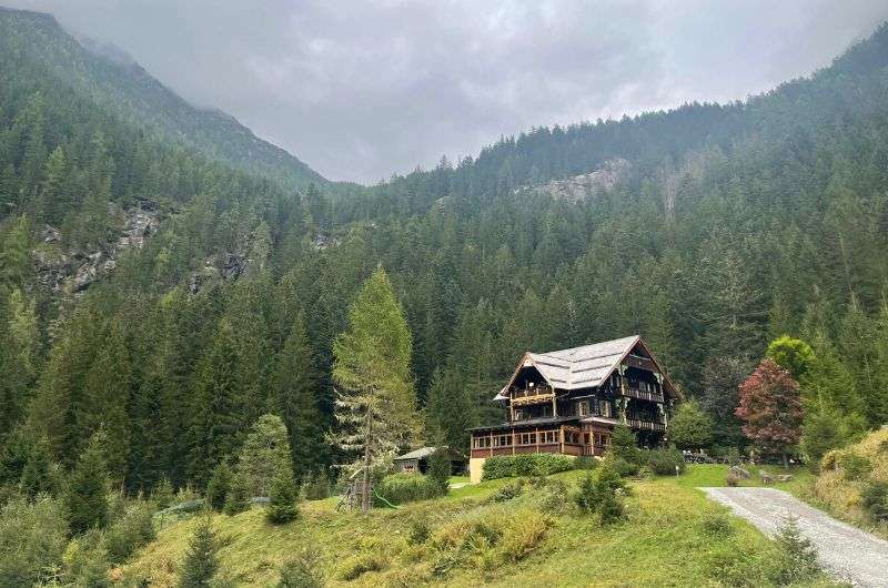
The renowned Alpenhaus Prossau
I will repeat myself, but it's that virgin nature all around you that makes the Prossau Valley hike special. And no crowds of tourists to avoid. But I will probably make this hike popular now, thanks to my article, so it might become a favorite tourist destination. Go now while you can still beat the traffic jams of humans!
Another thing that makes this hike special is that you have a clear goal (and I like goals). At the end of the valley, a divine inn, Alpenhaus Prossau, awaits you with local cuisine. The staff is dressed in traditional attire, and the food here is excellent; you can even have fresh fish and homemade sausages.
Trek around the famous waterfall!
Hike length: 8.5 km (5.28 mi) loop
Elevation gain: 262 m (859.6 ft)
Difficulty level: Moderate
Hiking time: 2,5 hours
Trailhead: Google Maps link to trailhead
Never heard of Vorderschneeberg? No worries, it's not exactly headline news. It's just a small village within the Bad Gastein area, home to about 600 souls. Its claim to fame? It's the 'finish line' of our hike, starting right from Bad Gastein and leading straight to Vorderschneeberg.
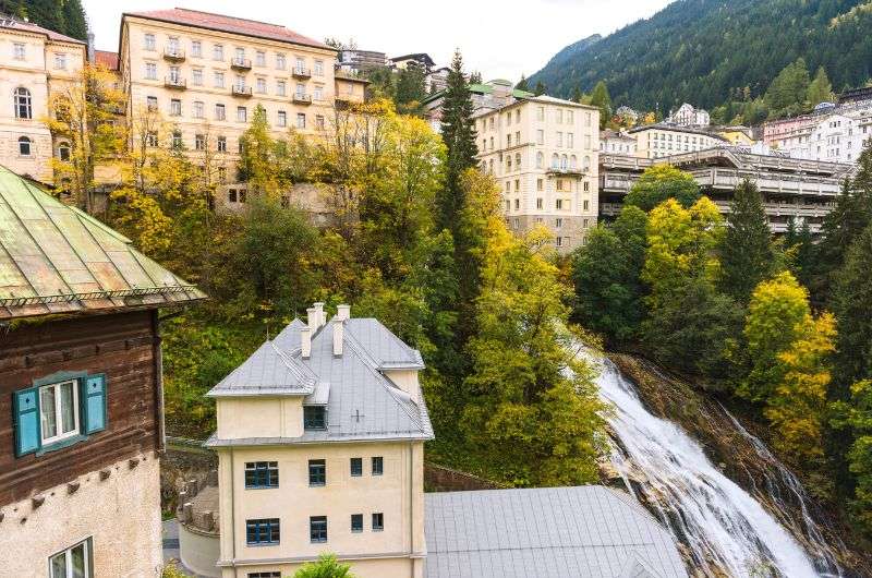
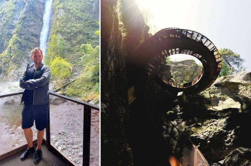
Am I overdoing it with waterfall talks? Maybe, but just a few hundred meters in, you'll hit Gasteiner Wasserfall, one of the most famous and intriguing waterfalls in all of Austria. It's also the main attraction of Bad Gastein.
There's an educational trail, Wasserfallweg, running along the waterfall. And guess what? That's exactly the path we're taking (walking and getting educated at the same time... priceless!).
Hope you like water, because this whole route follows the banks of the Gasteiner Ache River. You'll start descending, then it's mostly level until halfway. But logically, what goes down must come up—the second half is mostly uphill.
Bad Gastein itself sits pretty high, about 1,002 m (3,287 ft) above sea level. Where I come from, the highest peak is 1,603 m (5,259 ft), so this is quite a climb in my book.
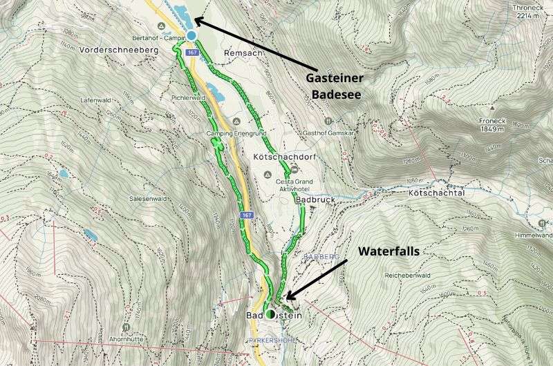
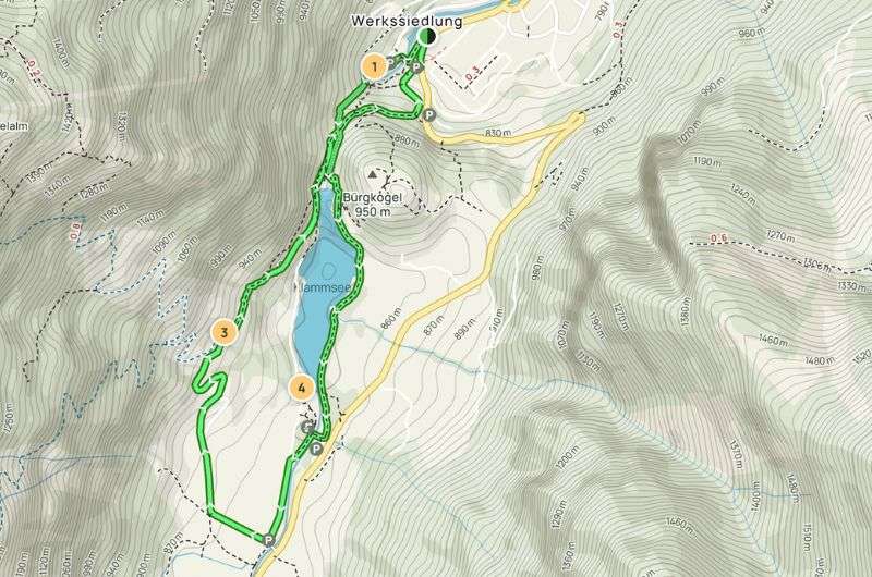
Map of loop Vorderschneeberg hike (see full details on Alltrails.com)
Tip: Right past the waterfalls, you'll pass the Gasteiner Museum. It's a small museum where you can soak up some cool facts about Bad Gastein's history.
At the other end of the trail is Gasteiner Badesee, a natural lake and a popular swimming spot. Perfect for a refreshing dip before heading back. Just brace yourself for the summer crowds...
There are many things to do on this hike
For me, Vorderschneeberg is about the mix of activities. I love that you're not just walking and admiring mountains and trees (not that there's anything wrong with that). On this hike, you see waterfalls, learn about the technical wonders related to them, visit a museum, and even take a dip in a lake. It's a fantastic combination.
Oh, and almost forgot—if you're up for some adrenaline, there's an exhilarating zip line ride over the Gasteiner Ache canyon. They say you'll be 'safely seated in the best seat of the Gastein Valley and will comfortably fly 90 meters high over the Gasteiner Ache Canyon.' Not sure if being scared stiff qualifies as 'comfortably flying, but hey, that's just my take.
The Liechtenstein Gorge
Hike length: 5.26 km (3.27 mi) out-and-back
Elevation gain: 220 m (720 ft)
Difficulty level: Easy (relatively)
Hiking time: 1.5 hours
Trailhead: Google Maps link to trailhead
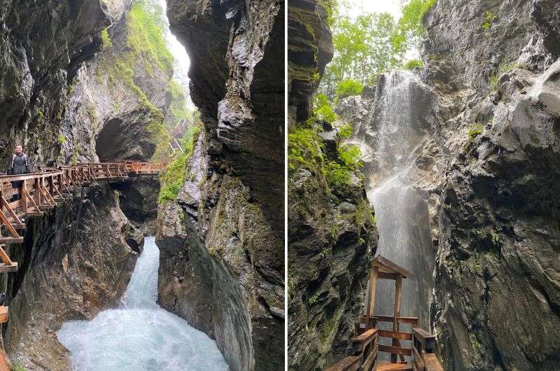
This gorge absolutely blew my mind. For the slower ones among you, 'Klamm’ in German means ‘gorge. ’ A hike along it is a no-brainer for this list.
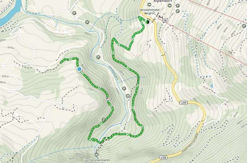
If you want to get all geographical about it, Liechtenstein Klamm isn't in Bad Gastein but a mere 45-minute drive north. If that’s too far for you, I don’t think we’re the same type of traveler. But it’s all good: if you're thinking of spending a night outside Bad Gastein in a more strategic location, then check out the fabulous four-star Aktivhotel Alpendorf in Sankt Johann im Pongau, just a hop away from the starting point of the Liechtenstein Klamm hike.
Start hiking early because this place is busy!
A little tip: Start the hike early. Based on photos on the internet ,we could see that the pathways that lead through Liechtenstein Gorge are narrow, so I didn't want to be in a traffic jam with e-cyclists and other day trippers.
According to the official website, the gorge is visited by 170,000 visitors annually. Universe forbid we all show up there on the same day!
We left the car in the parking lot, which is a short distance from the ticket counter, about 400 m. Inside the building where the ticket counter is, there's also a restaurant (if you are already hungry) with outdoor seating.
Map of out & back Liechtenstein Klamm hike (see full details on Alltrails.com)
Even though the trail is relatively easy, I recommend wearing comfortable shoes for climbing all those stairs. There are quite a lot of them here—I counted 440 (just kidding, I looked it up online). If you were planning on going with a stroller, leave it in the car. Not the kid, the stroller (use a carrier if you can’t get it to hike yet).
Very unordinary hiking trail
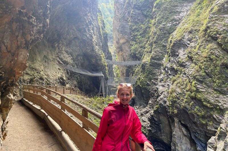
Even just the path through Liechtenstein Klamm is magnificent. You walk along a wooden walkway under various overhangs, tunnels, and valleys bordering transparent waterfalls. It is just not like the other Bad Gastein hiking trails. It's not about the views of the surrounding mountains and nature, but the place has charm all on its own.
Besides the epic natural phenomena and incredibly clear water, the pathway itself is a significant experience. At one point, the trail turns into a helix, a spiral staircase.
The only thing you see is a narrow path in front of you and behind you, with giant rocks towering 10 cm (4 in) apart. It might not be entirely pleasant for some. But if you're afraid the rocks might fall on you, you can rest assured—the trail and its surroundings undergo regular geological inspections, and in some areas, there are nets installed that protect you from any potential rockfall. All you need to do is hope the nets are in the right spots...
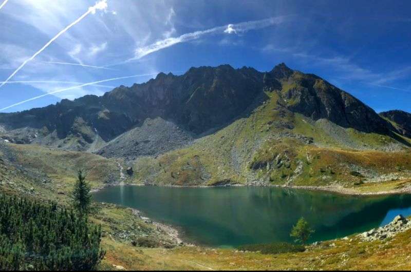
The beautiful lake on the Bockhart trail
Hike length: 12.6 km (7.83 mi) loop
Elevation gain: 730 m (2,395 ft)
Difficulty level: Moderate
Hiking time: 5–6 hours
Trailhead: Google Maps link to trailhead
You're going to love this trail if you're up for a challenge. You can drive to the trail's start and park comfortably at the lower station of the cable car. It's just a 12-minute drive from Bad Gastein.
For this trail, pack a big snack and plenty of drinks, as there's only one restaurant along the way, which you'll encounter at the beginning and end of the trail. During summer, bring your swimsuit too—you'll pass by two lakes that are perfect for a dip.
About 1.8 km (1.12 mi) in, you'll reach the first interesting stop—a wooden dragon by the trail. Personally, I'm not a huge fan of random animal statues on trails, but if you've got kids with you, it's a neat way to motivate them up the first climb.
Even if you're child-free, the sight of the dragon means you've conquered the first ascent. Time to head to the plateau along the lake.
Keep going. The stunning alpine peaks around you make the journey even more pleasant. Below you lies Unterer Bockhartsee, which you'll soon leave behind as you ascend to the lake's upper part, Oberer Bockhartsee.
If you're a waterfall enthusiast (like me), you're in for a treat. Like many trails in the Bad Gastein area, this one has its waterfall too. Some folks fill their bottles here, but I'd rather not—you never know if there's a dead cow lying upstream!
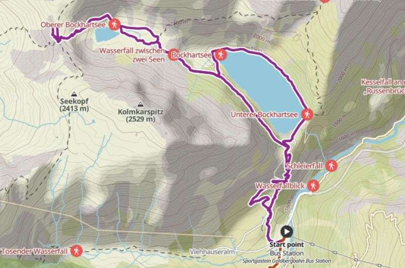
Really long one but not that hard (see the map on komoot)
Catch your breath and keep strutting your stuff. The last major climb awaits, so enjoy it while it lasts. Remember, whatever you climb, you must descend, and that's always, at least for me, the tougher part of any trip.
A few more meters, and you've conquered Bockhart Peak, marked by a cross. Surprised? Hope not, haha. The summit offers a stunning view of the valley you've climbed through. On a clear day, you can see the peaks of the opposite mountains.
What is special about the Bockhart hike?
What's nice about the Bockhart hiking trail is that you ascend along one side of the lakes and return on the other, allowing you to see and photograph the scenery from every angle. Feel free to take a swim in the lower lake.
Thanks to the large area where hikers can spread out, you might find yourself, as we did, walking alone for most of the journey. And that, for me, is a big win.
Now it's your turn: start in Bad Gastein and see where the incredible hikes take you!
Want a quick history lesson about the town you're thinking of staying in? Thought so.
Nestled in the Gasteinertal Valley, east of Salzburg, this picturesque mountain town offers stunning views of the surrounding Alpine peaks. And it's also a famous spa town, thanks to the healing waters from its thermal springs.
Bad Gastein has a surprisingly rich history that dates back to the Middle Ages, primarily because of one main attraction: its mineral healing springs.
During the Middle Ages and the Early Modern Period, locals began using these mineral springs for medicinal purposes. Thanks to some solid marketing (ha!), the 16th and 17th centuries saw an increase in visitors.
The 19th century brought significant development as a spa town, with the Belle Époque era ushering in an architectural boom and many new buildings. Bad Gastein maintained its reputation as a spa destination between the wars and continues to do so today.
Bad Gastein has kept its historical charm and remains a significant spa location in the Austrian Alps.
But enough nerding out, it’s time to hike! Which trail did you choose?
This post contains affiliate links. I earn a small commission if you make bookings through my links, at no additional cost to you. Thank you for your support!
Best hiking trails in Bad Gastein
1. Graukogel hike: The customizable winner
2. Grossglockner hike and Grossglockner drive: A double whammy that should’ve been in 1st place
3. Hike to Stubnerkogel: A challenge worth every step
4. The Sigmund Thun Klamm Waterfall hike: A seasonal must-see
5. Prossau Valley hike: The one with the rock wall
6. Vorderschneeberg Hike: More than just a trek
7. Lichtenstein Klamm hike: A gorge that’ll leave you awestruck
8. Bockhart trail: A Hike with pleasant surprises


Hi, I’m Jan. I travel fast and intensely, whether I’m exploring the buzz of Tokyo in 3 days or road-tripping through mountains and beaches on a 3-week Thailand adventure. And no matter where I am, you’ll always find me in a comfortable hotel at night and eating the best food.
If that sounds like your kind of journey, hop on board, and let’s explore the world together!
I started this blog after realizing how tough it can be to find reliable, authentic travel info. You wouldn’t believe how many “travel bloggers” never even visit the places they write about! On Next Level of Travel, you can count on my full honesty and insights drawn from my firsthand experiences.
Here’s the deal: not every destination is all superlatives and unicorns. I’ll let you know if a tourist attraction isn’t worth your time, like skipping overrated stops in my 2-week Spain itinerary. And when I find something truly special—like the perfect mix of culture and nature in Cape Town—you can trust that it’s worth adding to your itinerary.

Comments | Thoughts? Give us a shout!