

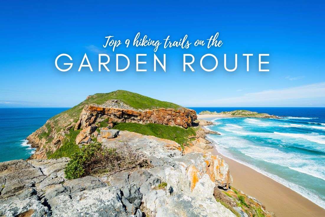
At a glance: The top day hikes in South Africa (ranked)
You could also be interested in reading:
1. Cape of Good Hope (Cape Town)
2. Platteklip Gorge to Table Mountain (Cape Town)
3. Storms River Mouth (Garden Route)
4. Day 1 Otter Trail (Garden Route)
5. The Three Rondavels in Blyde River Canyon (Panorama Route)
6. Tugela Gorge to Tugela Falls (Drakensberg)
7. Robberg Nature Reserve Hiking Trail (Garden Route)
8. Kirstenbosch National Botanical Garden (Cape Town)
9. Rainbow Gorge Hike (Drakensberg)
10. Half-Collared Kingfisher Trail (Garden Route)
Well, surprise, surprise! South Africa proves to be an ultimate haven for nature lovers and hikers. With so many hikes in South Africa ranging from coastal walks to challenging hikes in the mountains, and even the occasional strenuous trail, it’s no wonder this country is a dream destination for anyone who loves the great outdoors (like me).
This country has it all: solid infrastructure—check. Friendly locals—check. Hiking opportunities all year round—check. Each place boasts a unique vibe—check.
And as a little bonus, you’re almost certain to encounter some cool fauna on the hiking trails in South Africa: think zebras, ostriches, snakes, leopards... No worries though, elephants, rhinos, and lions tend to hang out more in places like Kruger National Park, so you won’t be randomly bumping into them.
I tend to hike the heck out every place I visit, because I a) just can’t sit still, and b) love being smacked in the face by nature’s amazingness.
I’m no hippie, and I hate camping (unless it’s some sort of ultra-comfy adventure “tent” like Ndhula Luxury Tented Lodge) but no human-made tourist site can ever beat what Mother Nature whips up. She’s the OG master builder!
So, here are the places I loved most for day hikes in South Africa in places like Tsitsikamma National Park and other Garden Route wonders, Drakensberg, Cape Town, and more! They are everything from easy to hard and short to semi-long. Ready?
Read more from my South Africa travel itinerary.
I’ve ranked the best one-day hikes across South Africa based on how spectacular, varied, and memorable they felt (details and experience below).
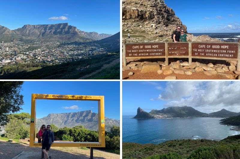
Feelin’ good on the Cape of Good Hope
Hike length: 4.7 km (3 mi) out-and-back with some detours along a mostly flat trail
Elevation gain: 270 m (885 ft)
Difficulty level: Easy
Hiking time: 2 hours minimum, but you should spend at least half a day here exploring the surroundings
Trailhead: Google Maps link to trailhead
Hotel in Cape Town: Dysart Boutique Hotel
Even after two extended South Africa trips under my belt with vast hiking exploration, I’m sticking to Cape of Good Hope as my favorite one day hike in South Africa (with Table Mountain a very close second!).
Let me tell you, this place is where nature turned up the dial to max awesomeness. Seriously, if I could, I'd set up camp there—right amidst the stunning views and coastal beauty (note to self: retire in South Africa).
The entire park is a treasure trove of nature's wonders and critters. Brace yourself for some primate encounters, but even though those baboons might be cute, but they've got a mean bite, so keep your distance. And my girlfriend even armed herself with some rocks when she saw how close (and how big!) the ostriches were.
Although I must admit, I'm not sure how that strategy would play out against a 2-meter-tall, larger-than-life bird. My money's on the ostrich.
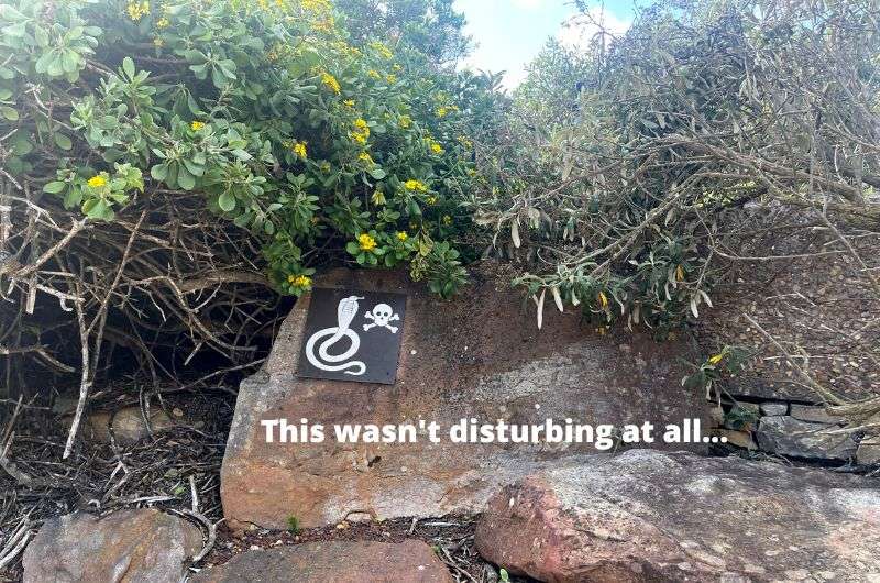
I like snakes, but I like myself better, so I was very careful where I stepped
Here's a tip: park at Cape Point and make a beeline for the lighthouse first. That cliff view? It's mind-blowing, easily one of the best I've ever seen. Then, don’t forget to make a detour to Diaz Beach—it is stunning! And not a lot of people make their way down their (lazy bastards). And while you're at it, don't miss the shipwrecks.
If you add all the jaw-dropping viewpoints and side trails at Cape of Good Hope (surprisingly part of Table Mountain National Park), this hike will easily chew up a good chunk of your day. Make sure to take enough water, a wind-proof jacket and some sun protection.
I recommend getting an early start at Cape of Good Hope, because this hiking trail is a very popular day trip from Cape Town, and you can expect busloads of tourists on the trail starting at around 10 am. Hey, what did you expect, that you’ll have one of South Africa’s best hiking trails all to yourself?
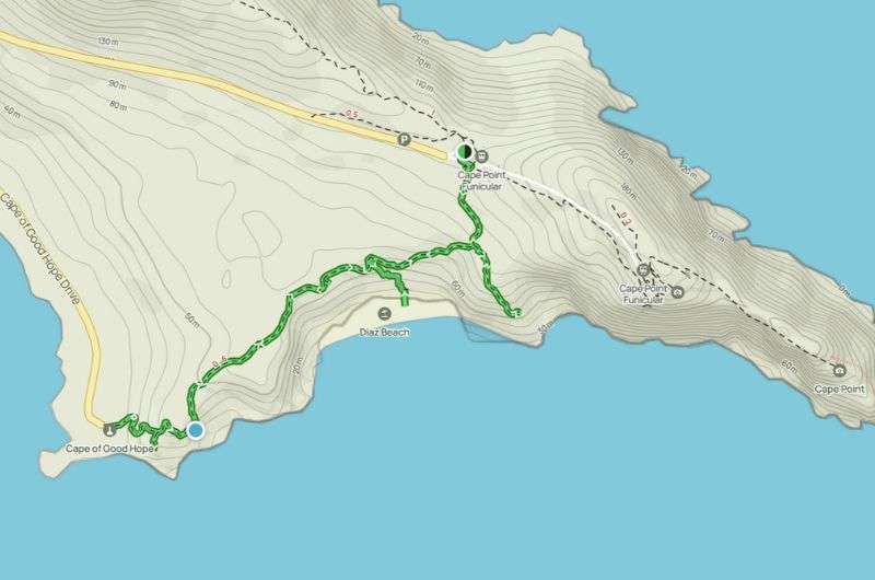
An absolute highlight of a hiking trail in South Africa, Cape of Good Hope (see the map on Alltrails)
You have so many options for hiking around Table Mountain!
Hike length: 3 km (1.8 mi) point-to-point (you usually take the cable car back down)
Elevation gain: 700 m (2,300 ft)
Difficulty level: Moderate
Hiking time: 1.5 hours if you’re reasonably fit, longer if you’re not
Trailhead: Google Maps link to trailhead
Hotel in Cape Town: Dysart Boutique Hotel
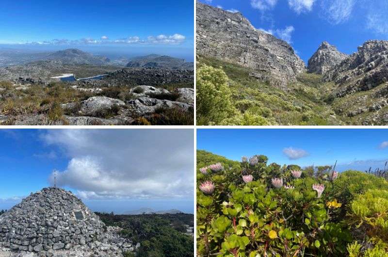
You could spend all your time in South Africa hiking around Table Mountain if you wanted to! That would be pretty twisted, but hey, no judgement. There are around 200 hiking routes on Table Mountain alone, so I’m not being that unreasonable (really).
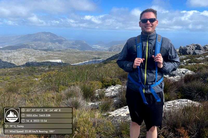
That said, I’ve visited Table Mountain numerous times and every time it is just so magical. The hiking trail we took on Table Mountain is one of the most popular routes: the Platteklip Gorge. I have to warn you that from down below it looks much easier than it is in reality.
It’s the oldest, most direct route takes you straight up the gorge to the plateau, making it a pretty strenuous trail, but also very easy—it’s next to impossible to get lost on this route. Just follow the beaten zig-zag path.
It’s usually a one-way endeavor, since you end up at the cable car station and use that to go back down after you’re done exploring on the top (save your knees!). The wind could potentially throw a wrench in those plans, with the cable cars coming to a halt when the air gets a little too wild.
What to expect on the Platteklip Gorge Hike? No shade, lots of uneven, high stone steps, slippery in parts, and epic views. That is, unless you get caught in heavy clouds or fog, in which case, keep in mind the rocks of the mountain are 600 million years old... so, you know, even if you have to keep your gaze down, you could see that as a silver lining.
Hey, I’m trying to be optimistic here!
Nothing else to report on this hike alone, but Table Mountain is one of the most incredible places in all of South Africa, so don’t you dare miss it, no matter which hiking trail you take. Here are some fun facts about Table Mountain.
Tip: Use my Cape Town itinerary to plan your next trip. Or perhaps my full South Africa itineraries?
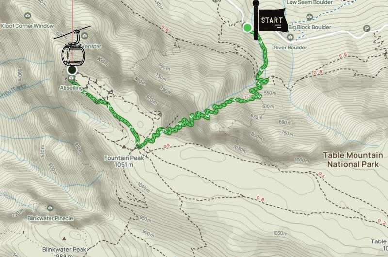
Get the trail map on Alltrails
When’s the best time to visit Table Mountain?
There’s really no bad time to visit Table Mountain. It’s beautiful in all seasons. The best time is fall or spring though. The temperatures are ok and if you’re lucky, it’s also sunny. However, from December to February (the summer) it may be a little too challenging for some as the sun beats you down the whole route.
Take it from an experienced traveler
We visited Table Mountain in May when it’s fall in South Africa and it was to-die-for.
Prepare steady shoes and adequate water supplies no matter when you visit. I’d always take a hat and sunscreen, but also an extra layer—it can get colder on top!
Table Mountain is also famous for the tablecloth of clouds. Every time the south-eastern winds blow from the coast, thick clouds form all over the slopes. It doesn’t mean it will rain necessarily. The mist and the clouds usually disperse after a few minutes. I must say it feels magical being up there, and that’s something coming from me.
The smoking contest: Legend has it that there was a smoking contest between a Dutch pirate living on the east side of Table Mountain and the devil. Once, when the pirate was smoking outside his hut, the devil appeared out of nowhere and challenged him about who can create more smoke. So, if you ever see the tablecloth covering the mountain it’s these two idiots' fault.
Storm River Mouth—my favourite hike on Garden Route
Hike length: 3.7 km (2.3 mi) out-and-back
Elevation gain: 200 m (655 ft)
Difficulty level: Easy to moderate (if you really don’t like stairs)
Hiking time: 1.5 hours
Trailhead: Google Maps link to trailhead
Hotel near Knysna: Kambaku at Sea
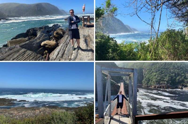
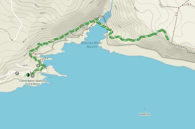
Storms River Mouth was my favorite place on the Garden Route (which in turn was one of my favorite places in South Africa), and luckily for you there’s a trail that’ll allow you to see the very best of the best views there. Think dense forest, spectacular coastal scenery, and some fun suspension bridges to add to the fun.
Everyone and their grandma does this route since it’s one of the Tsitsikamma National Park hiking trails aka the most amazing part of the Garden Route. It’s also a stone’s throw from the beginning of the Otter Trail (see next item on this list), so it’s a popular spot.
The Storms River Mouth trails starts at the parking lot near Untouched Adventures (the people that do kayaking trips into the river mouth and gorge—also very much recommended!) and make your way to the 3 bridges. You’ll walk through a gorgeous indigenous forest and on wooden paths.
The suspension bridges are good fun, though you might get stuck in a human traffic jam when people hold up the flow taking photos on themselves on the main bridge. I’m not complaining though, because not only was I one of the people taking photos on the bridge, you’ll also be standing right above the wild waters of Storms River mouth below. Not bad for a stop-and-stare!
After the suspension bridges, the trail goes up some steep stairs. You can scramble even higher up to get to a cool viewpoint when you reach the end.
The steep part of this trail starts after the suspension bridges (see full details on Alltrails)
We got to see plenty of baboons and vervet monkeys on this trail, too. I’m telling you, this place is unbelievably wild and beautiful!
It’s certainly not a hard route, and even with the stairs at the end it’s just a good workout and nothing too strenuous.
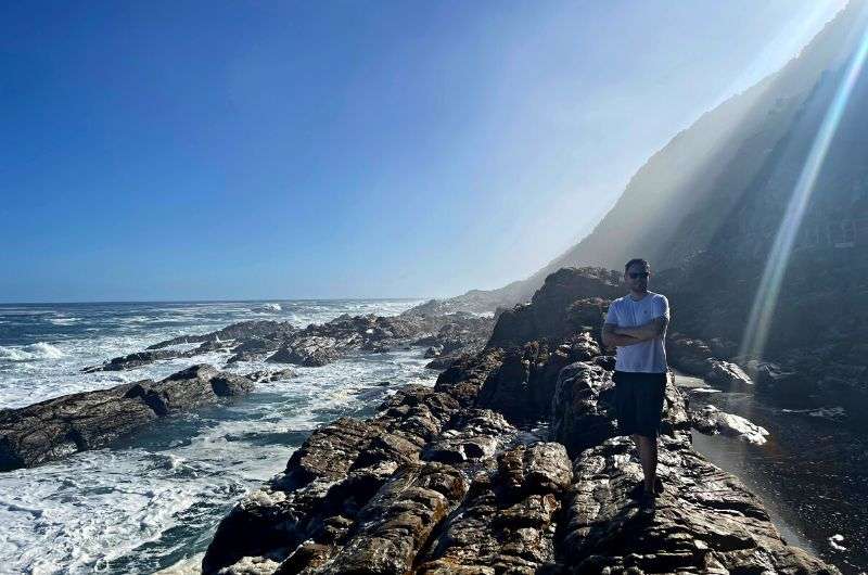
This isn’t me just taking a photo by the sea. This is me on the actual Otter Trail. Not much of a trail and more of a scrambling seaside adventure! Loved it!
Hike length: 4.8 km (3 mi) out-and-back
Elevation gain: 135 m (440 ft)
Difficulty level: Moderate
Hiking time: 2–3 hours
Trailhead: Google Maps link to trailhead
Hotel near Knysna: Kambaku at Sea
This hike is right next to Storms River Mouth and follows the first section of South Africa’s famous 5-day Otter Trail, hence the name. It’s not very long, but it definitely gives you an idea why the Otter Trail is so popular. It’s technically challenging because you’re on rocks and boulders most of the way, but who doesn’t love some shoreline scrambling?? I sure do!
Tip: If you are someone that enjoys multiday hikes, the full Otter Trail, a classic overnight hike with overnight huts, is one of South Africa’s finest trails, is one of South Africa’s finest trails.
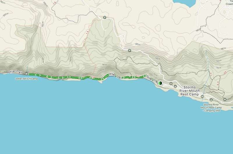
The Day 1 Otter Trail hike begins at the end of the Storms River Rest Camp and goes all the way to a waterfall and then back the same way (which is also why it gets referred to as the Waterfall Trail of Tsitsikamma).
It delivers unbelievable scenery—you’re in the luscious forest one moment and exposed on the boulders right next to the wild ocean the next. Seriously, the waves were something like 3–4 m high when I hiked the Otter Trail, it was insane!
Beware that the rocks can get slippery and that there’s a fair bit of scrambling, but if you aren’t a total klutz or wearing flip flops, you’ll do just fine. I saw people of all ages on this route, so instead of “hard”, I’d describe it as “adventurous and fun”. If a 5-year-old can do it, you can too.
Day 1 Otter Trail (get full map on Alltrails)
It's coastal Mordor vibes all around, sharp coastal cliffs making the scene look like a movie set. Every step feels like a leap into adventure, especially when the path turns rocky. And hey, rocky's my kind of terrain.
The route is pretty straightforward, just remember not to veer off anywhere. If you’re having to make turns, you’re probably not on the Otter Trail anymore.
There is a cave roughly in the middle of the Day 1 Otter Trail if you want to do see some bats. The hike ends at the waterfall. It’s very pretty, and people like to swim in the rock pools there and have a snack before heading back. Take your own food and water, there are no facilities.
You don’t need to book the one day Otter Trail, unlike the full hike. You’d better time your hike appropriately though, since high tide can turn this into a more of a challenge than you’d like. We did the entire day hike in about 2 hours, so you can definitely pack light.
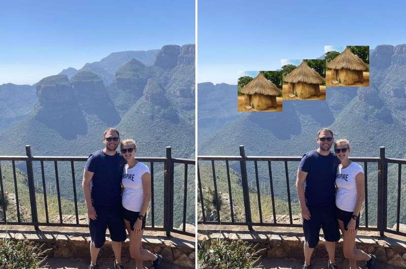
Can you see it now? @ The Three Rondavels Viewpoint
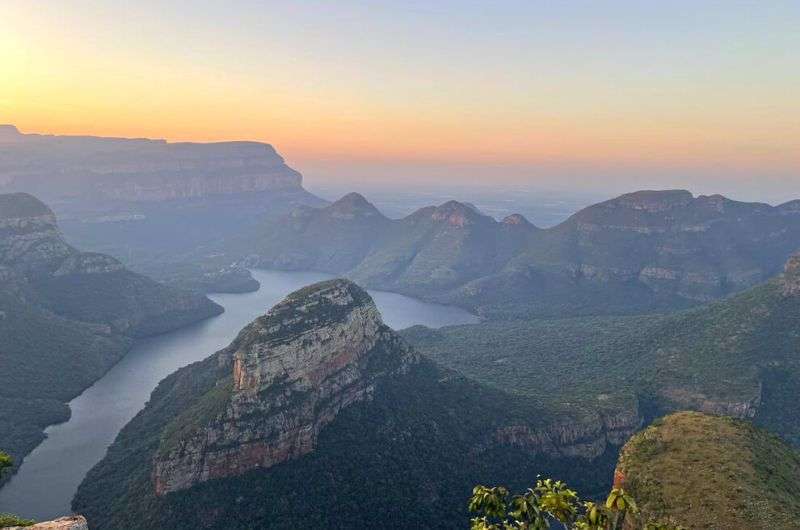
The Three Rondavels viewpoint is barely counts as a hike, but I have to include it because the views of Blyde River Canyon are just unbelievable. It’s the 3rd largest canyon in the world, so it’s no little dent in the Earth!
It’s lush and green, 800 m (2,600 ft) deep, and just so different than other canyons (see Fish River Canyon in Namibia or Colca Canyon in Peru).
It’s like no other place I’ve been to before—I was blown away.
Tip: I loved the Three Rondavels so much I think they are worth more than one visit. That’s why it’s a stroke of pure genious to exlore the Panorama Route from Hoedspruit (stay at Little Kubu Lodge for the best hotel experience EVER). That way, you can stop by the viewpoint in the morning and then again in the evening.
Here’s a Panorama Route itinerary that shows you how.
Once you park at the roundabout parking area, the Three Rondavels viewpoint is just a couple of minutes walking distance. Actually, there are two official viewpoints, and then you can just wander anywhere in between, which is why I feel entitled to put the Three Rondavels on a hiking list (and read the end of this item to learn about another Blyde River hike you might be interested in).
Explore within reason—nobody’s going to go looking for you when you fall off into the abyss taking a selfie, and I just suggest you stay on the trails, because the cobras that live in these areas really don’t like it when humans step on them.
It took us a full hour to get enough of this view from the various lookout points, with a lot of staring and oohing and aahing. See, hiking! But wait, there’s more!
There’s a second viewpoint area a little to the north from the Three Rondavels, with trails starting close to the Blyde Canyon, A Forever Resort. The hike follows the Guinea Fowl trail and Leopard Trail and takes 2.5–3 hours to complete.
You can even book a guided cruise on the Blyde River Canyon Dam.
If you give yourself 2 days for the Panorama Route (here’s the itinerary I suggest), you’ll have enough time for this rocky, fun route and the great little swimming places you’ll encounter.
Tip: The gates at the Three Rondavels close at 5 pm, but with a little smile and some negotiation skills (and possibly a generous tip), the lovely gate attendant may let you stay a little longer for one of the most memorable sunsets you’ll experience in South Africa.
Blyde River Canyon view at sunset, totally worth the negotiations at the gate
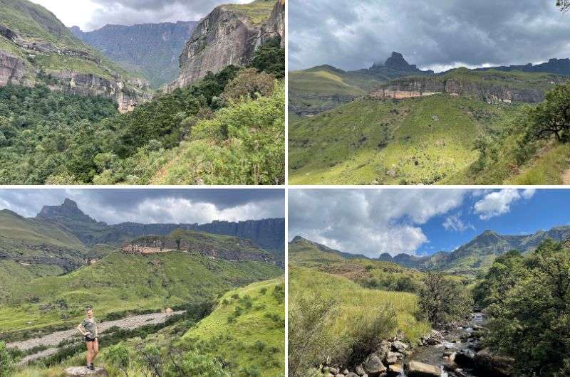
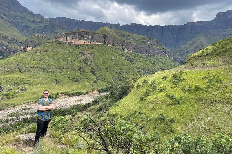
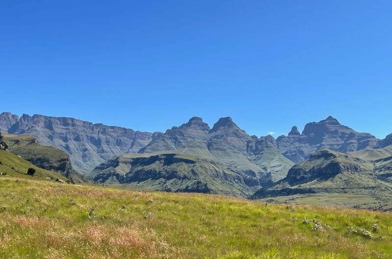
Tugela Gorge—what a challenge!
Hike length: 14 km (8.5 miles) to viewpoint, more if exploring beyond the ladder
Elevation gain: 750 m (2,460 ft)
Difficulty level: Moderate to hard
Hiking time: 4 hours round-trip to viewpoint, another 2 hours if taking the chain ladder route
Parking and trailhead: Near Thendele Camp, see it on Google Maps
Hotel in Drakensberg: Dalmore Guest Farm (bonus: best steak I’ve had in a very long time!)
This hike is an incredibly fun adventure—you’ll be crossing the river, hopping and scrambling on boulders, searching for a hard-to-find cave, and possibly taking a dangerous (?) chain ladder to try to get as close to Tugela Falls as you can.
We went on the Tugela Gorge hike in April 2023, when the end of this hike had been claimed by a landslide some time before, making it officially inaccessible.
We didn’t dare climb up the rickety-looking chain ladder when there was a sign there warning us against it. But by the looks of some of the newest updates online, the sign is mostly taken with a grain of salt nowadays, with people happily making their way all the way to the end of the trail, ladder included. So you do you.
The initial 2 km take you through a semi-jungle, providing an easy and pleasant pathway. Once you cross the wooden bridge, the real magic unfolds. Those amazing views are nothing short of spectacular—the mighty Amphitheater is a cliff three times the size of El Capitan in Yosemite!
It’s very much worth it even without the last bit that you’d need to climb the ladder for. Then things get a little wild, with no real path (because where would it be, drawn on the rocks??).
Once you get to the chain ladder, you can go that way, or turn your back to it and find a smaller wooden ladder. Climb up that for some pretty sweet viewpoints!
Tip: Fascinated by Tugela Falls? Consider hiking up to the very top of them! There’s chain ladders galore there, too! See the first hike on my Drakensberg Best Hikes List for details.
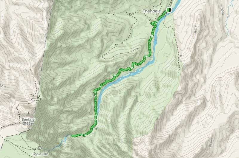
This map shows the full hike, including the “forbidden” chain ladder at the end (map from Alltrails)
When’s the best month to go on the Tugela Gorge hike?
Even if you don’t dare go against the mighty authority of the warning sign, you’ll still get fantastic views of the surrounding cliffs and mountains, and you can still see the waterfall—if it has enough water when you go. Then again, if there’s too much water, like after some heavy rains, some spots can become impossible to cross.
Tugela Gorge is full of surprises
The best time to go on the Tugela Gorge hike is March to May. If you go in September to November, there may be no waterfall at all. December through February will be way too much water in the river and a high chance of thunderstorms, and June to August is just too cold.
So you see, the Tugela Gorge hike isn’t clear-cut and you may just need to go there and see what you get. Like those mystery bags you got at fairs as a kid.
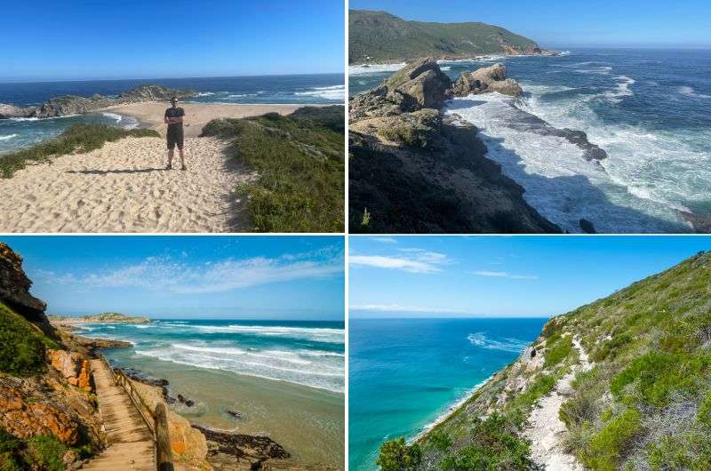
The amazing scenery on the hike in Robberg Nature Reserve
Hike length: 8.7 km (5.4 mi) loop, with the option to cut it in half
Elevation gain: 280 m (920 ft)
Difficulty level: Easy to moderate
Hiking time: 2.5 hours for the full trail
Trailhead: Google Maps link to trailhead
Hotel near Knysna: Kambaku at Sea
This day hike is another one of my favorites in South Africa, right up there with places like De Hoop Nature Reserve. Yes, it’s the millionth one on the Garden Route, but that just goes to show how unmissable the hiking in these parts of South Africa is. The ocean just elevates the magic, man.
The Robberg Peninsula hike is a 8.5 km (5.3 mi) route that feels like multiple hikes in one—it keeps changing and stays interesting the whole time (though the sandy part was not my favorite!).
First things first, I recommend stopping at Nelson Bay Cave close to the parking lot. It's an interpretation center that educates you on the story of the local San and Khoi people, their local lives spanning 120k years. Very interesting stuff. You know I love me some timelines!
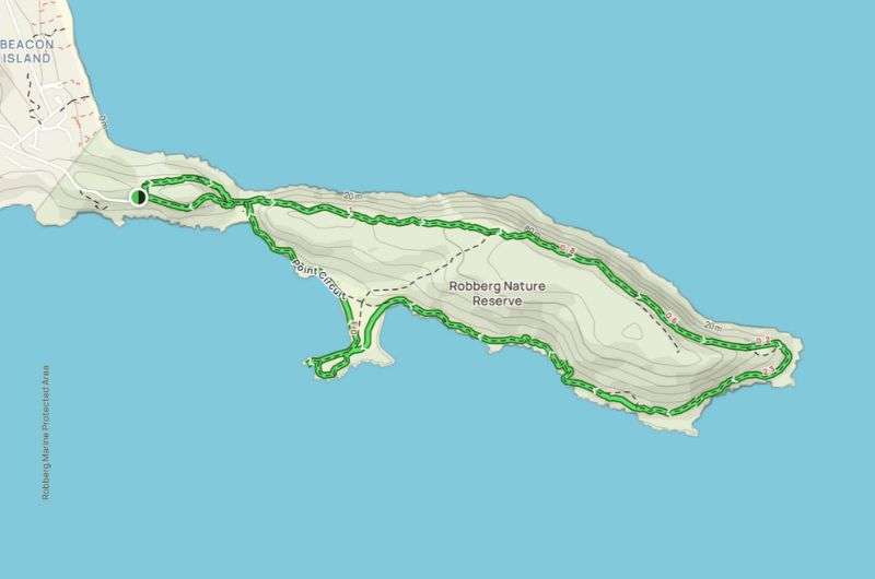
You’ll circle the entire peninsula on the Robberg hiking trail (but there’s an option to cut it in half) (full route details on Alltrails)
Then, the Robberg hiking trail continues with jaw-dropping coastal goodness all the way, though if I were to do it again, I’d opt for the shorter version, where you cut through the peninsula in the middle and skip the sandy shuffle of the longer route.
Also, whatever those little insects were, they were annoying as heck and stung, too!
But, if you don’t mind a long sandy walk, the full route will still only take you about 2.5 hours. Some sections of this route are quite steep, but there are ropes you can hold onto. I saw some people opting to scramble on the rocks instead of walking on the sand in some places, so that’s an option, too.
Be ready to encounter a very large and smelly seal colony, and you can also try to spot whales from the higher ground.
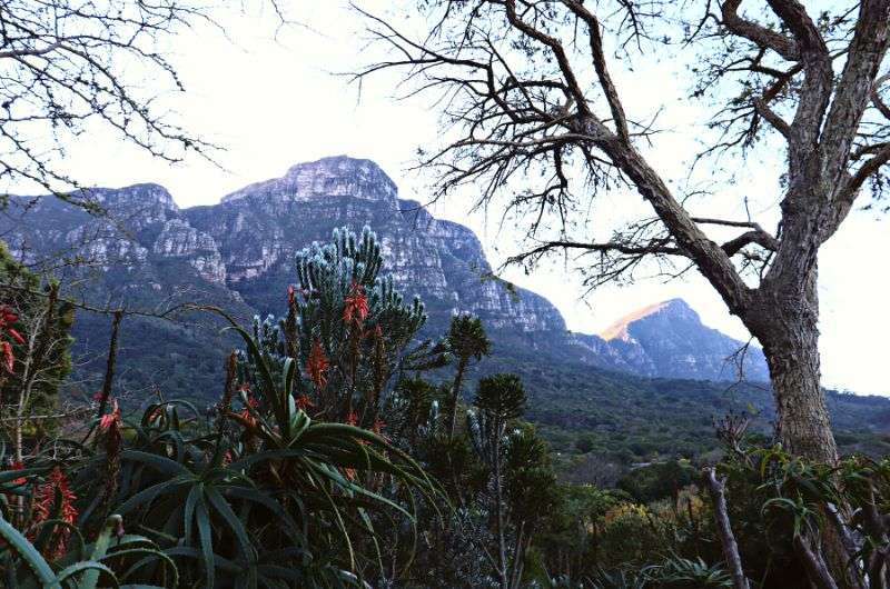
Kirstenbosch National Botanical Garden
Technically not a hike but an incredible walking area nonetheless. That’s what you’re here for, right? South Africa’s finest trails? Well, there are trails at the botanical garden, and there are plenty of them, so I dare you to not consider this a hiking spot.
Each time I step into this gem of a park, it's like a slap of beauty right across the face. I mean, seriously, how does Kirstenbosch Botanical Garden manage to keep getting more stunning? With each visit, I'm treated to fresh perspectives of Table Mountain and an array of routes that keep my wanderlust alive.
I—the snake-lover that I am—am always on the lookout for the resident snakes, especially the Cape Cobra which goes by the oh-so-funny name Nivea in Latin. I mean, really, Nivea—sounds like it's ready to break into a skincare commercial.
But enough about snakes, let's talk about what really makes Kirstenbosch unique: the Cape floral kingdom. Seeing all the indigenous species in the garden is impressive even for us non-floral types.
Pro tip: Make life easier and purchase the entry ticket online.
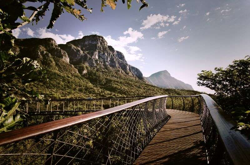
This is the Bloomslang!
And don't even get me started on the views from the Boomslang—the super cool bridge that snakes its way through the treetops!
As for time spent, well, I can hang out anywhere from 1 to 5 hours, depending on whether I decide to conquer every nook and cranny and try to discover a new plant to name after me (I like the ring of “Janus Travelus Epicus”) or just take a quick walk.
Plus, let's not forget, one of the grand entrances to Table Mountain begins right here. And parking? Easy-peasy. Kirstenbosch knows how to welcome its eager explorers.
Hotel in Cape Town: Dysart Boutique Hotel (check out the dog statues out front, and my favorite part: the bathroom!)
Rainbow Gorge—you don't have to walk through the jungle to earn this view
Hike length: 5.6 km (3.5 miles)
Elevation gain: 200 m (560 ft)
Difficulty level: Easy to moderate
Hiking time: 2 hours
Parking and trailhead: Didima Camp, see it on Google Maps
Hotel tip: Cathedral Peak Hotel
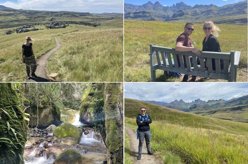
You can’t visit South Africa and not go hiking in the Drakensberg. And Drakensberg’s Rainbow Gorge will knock your hiking shoes off right from the start, with Cathedral Peak and other majestic mountains visible from the get-go.
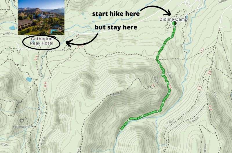
The hike starts at Didima Camp (see it on Alltrails), but I strongly urge you to stay at Cathedral Peak Hotel. You know you deserve some active R&R in incredible surroundings!
You set off on the hike right from the Didima Camp Cathedral Peak where you can park your car. I’d say the Rainbow Gorge hike is easy, but I guess the steeper section in the beginning could make it moderate for some people. But after the first kilometer or so, it’s flatter than the Serengeti after the wildebeest migration.
You probably won’t even notice the incline, though, because the views of Cathedral Peak are beyond believable.
Then, you walk through the gorge, and finish up by the rock pools at the end after walking through the forest. It gets humid under the treetops, so you can expect a mildly slippery and wet ground. Dip your toes in the pools, have a picnic, and then head back the same way.
All in all, about 2 hours including a little stop at the end.
Tip: I was thoroughly impressed by this part of the Drakensberg, and next time I’d easily spend 5–7 days just exploring the area. There is so much to see and do! If you book yourself into the Cathedral Peak Hotel you don’t even need to leave the grounds for the first couple of days. There’s a swimming pool, golf course (with those views!!), tennis court, a wellness center, and more. Like horseback tours for those that, unlike me, don’t have horse allergies.
The Rainbow Gorge hike was quite easy
Hike along a nice forest path with a waterfall at the end as a reward
Hike length: 7.6 km (4.7 mi) out-and-back
Elevation gain: 270 m (885 ft)
Difficulty level: Easy
Hiking time: 2 hours
Trailhead: Google Maps link to trailhead
Hotel near Knysna: Kambaku at Sea
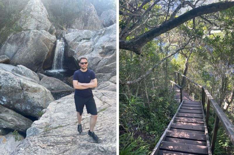
The Half-Collared Kingfisher trail is a fun one, and easy enough for the whole family. And, this being the Garden Route, very pretty, too. It’s a shaded hike alongside the river leading to a waterfall that's like a natural pool—perfect for a refreshing swim. We did the hike in about 2 hours.
More a walk than a hike, you’ll be strolling mostly on a well-maintained wooden walkway under a canopy of trees. Whoever built this deserves a high-five, it must’ve been quite an undertaking. There are some stairs and a river crossing, but they add to the fun. This hike really can be done by almost anyone.
The pontoon bridge at the start of the trail is definitely a highlight, because you feel like you’re entering a secret area. I was as giddy as a kid on Christmas, pulling us along, feeling all strong and manly as I muscled us to the other shore.
There’s also an alternate path that’ll take you across the river on stepping stones. It’s a little bit further along the river than the pontoon bridge (from the beginning of the trail).
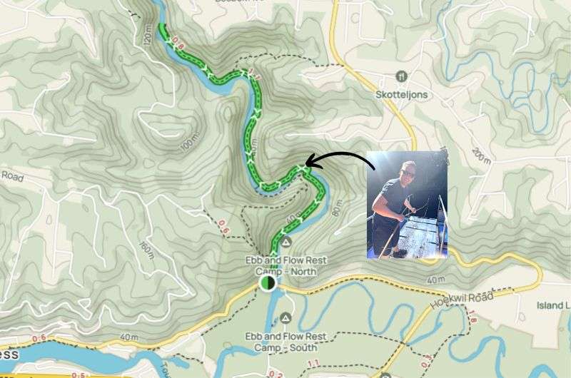
The pontoon bridge comes after the first 15 semi-boring minutes of the Kingfisher trail. That’s where the fun really starts!
We hit the Vervet monkey jackpot on the Half-Collared Kingfisher Trail—those cheeky little devils almost swiped our phones, so stay aware if they start looking a little too interested. Apparently, the normally elusive species is used to all the humans coming through on the hike, so you can see them pretty often.
The waterfall at the end is nice, but don’t think of it as the highlight. The setting that the waterfall is in is much more spectacular than that bit of water falling.
The return hike is the same route, but there are some areas near the beginning of the trail where you can turn it into a loop. This Alltrails map shows the extra paths.
Tip: You can also canoe part of the way up the trial and walk the rest. See how in my 5-day Garden Route itinerary.
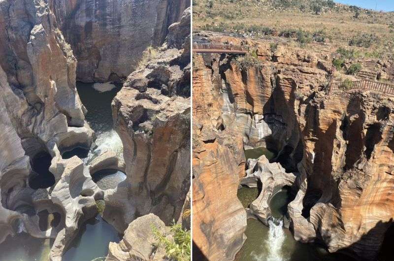
Amazing Bourke’s Potholes!
For an easy, max 1-hour-long hike/walk in the northeast corner of South Africa, visit Bourke’s Luck Potholes. You wouldn’t know it from the name, but this place along the popular Panorama Route will leave you gasping for words, and maybe air if you're too awestruck.
It's like Mother Nature decided to create a mind-boggling masterpiece just to show off, sassy lady that she is.
Then man came along and put a bunch of wooden walkways and bridges to stare at the potholes from all angles. Thanks, man, for turning this into suck a fun activity! The full basic trail from the parking lot, with a loop around the river area, is a total of 2 km/1.2 miles long.
Bourke’s Potholes is a series of cylindrical rock formations formed by centuries of the river water swirling away. The relentless force of the water, coupled with abrasive sand and rocks, carved these magnificent potholes into the bedrock.
Tip: I strongly encourage you to do the Panorama Route from Hoedspruit and spend your nights at Little Kubu Lodge—this was the best hotel we stayed at in South Africa. Also, if I were to do it again, I’d take 2 days to see the Panorama Route, not one. I’ve put both a 1-day and a 2-day Panorama Route itinerary together for you in a separate article.
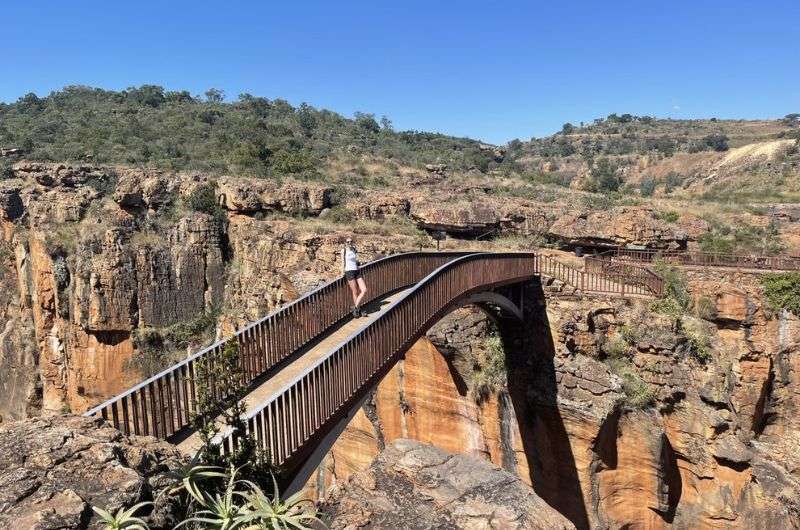
On the bridge above Bourke’s Potholes. You can see the route is easy to follow
Easy and pleasant hike to the Big Tree
Hike length: 1.3 km (0.8 mi) loop or extend 2.5 km on the Yellow Trail
Elevation gain: barely any
Difficulty level: Easy
Hiking time: 30 minutes
Trailhead: Google Maps link to trailhead
Hotel near Knysna: Kambaku at Sea
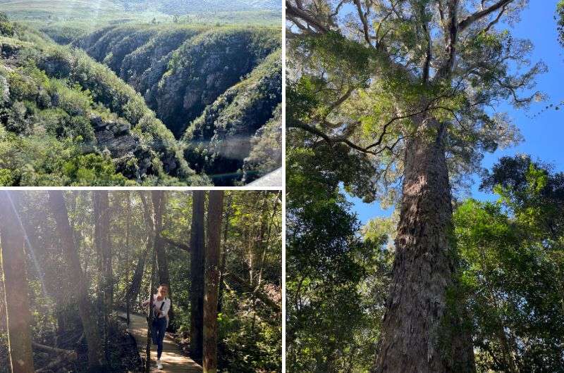
Last and sort of the least, this extra short trail is only a 30-minute undertaking, but the main star was so impressive I wouldn’t dare leave it out of my list. For an extra easy hike in South Africa, take the Big Tree Trail. It’s not a hike by any means... you’ll be walking on a wooden pathway, accompanied by the traffic noise from the highway, but still mesmerized by the beautiful forest you’ll be passing through.
And then... a Outeniqua Yellowwood that casually stands at 38 m (125 ft) and is 800 years old. I was all prepared for some regular trees, but whoa, this tree was something else!
You can stretch this “hike” out a little further and keep exploring along the Yellow Trail. It’s a walk in the OG forest, around 3.5 km (2.2 mi) total, with a good chance of running into spiders and snakes. If that motivates you or deters you from the walk is up to you. There are at least two other huge trees further down this trail if that helps.
Alright everyone, I think it’s clear that the hiking trails in South Africa are calling your name. They are so diverse that you’ll find the perfect day hike no matter what your fitness level or scenery preferences are. My only suggestion would be to read up on my South Africa safety tips before you go out exploring the unknown. There are some bad apples out there, so keep your wits about you!
I’ve included plenty of day hikes in my South Africa itineraries, so check those out if you’re feeling overwhelmed with planning. No need to re-invent the wheel people, Jan’s got you covered!
This post contains affiliate links. If you make a booking through one of my links, I may earn a small commission—at no additional cost to you. Thank you for your support!
At a glance: The top day hikes in South Africa (ranked)
You could also be interested in reading:
1. Cape of Good Hope (Cape Town)
2. Platteklip Gorge to Table Mountain (Cape Town)
3. Storms River Mouth (Garden Route)
4. Day 1 Otter Trail (Garden Route)
5. The Three Rondavels in Blyde River Canyon (Panorama Route)
6. Tugela Gorge to Tugela Falls (Drakensberg)
7. Robberg Nature Reserve Hiking Trail (Garden Route)
8. Kirstenbosch National Botanical Garden (Cape Town)
9. Rainbow Gorge Hike (Drakensberg)
10. Half-Collared Kingfisher Trail (Garden Route)


Hi, I’m Jan. I travel fast and intensely, whether I’m exploring the buzz of Tokyo in 3 days or road-tripping through mountains and beaches on a 3-week Thailand adventure. And no matter where I am, you’ll always find me in a comfortable hotel at night and eating the best food.
If that sounds like your kind of journey, hop on board, and let’s explore the world together!
I started this blog after realizing how tough it can be to find reliable, authentic travel info. You wouldn’t believe how many “travel bloggers” never even visit the places they write about! On Next Level of Travel, you can count on my full honesty and insights drawn from my firsthand experiences.
Here’s the deal: not every destination is all superlatives and unicorns. I’ll let you know if a tourist attraction isn’t worth your time, like skipping overrated stops in my 2-week Spain itinerary. And when I find something truly special—like the perfect mix of culture and nature in Cape Town—you can trust that it’s worth adding to your itinerary.

Comments | Thoughts? Give us a shout!